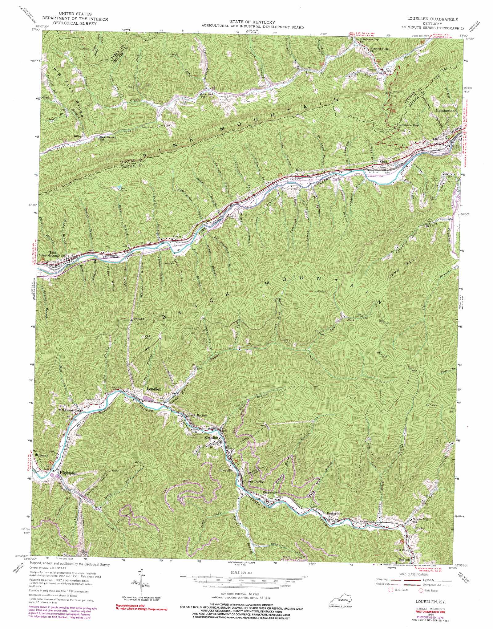
Louellen Topo Map Kentucky
To zoom in, hover over the map of Louellen
USGS Topo Quad 36083h1 - 1:24,000 scale
| Topo Map Name: | Louellen |
| USGS Topo Quad ID: | 36083h1 |
| Print Size: | ca. 21 1/4" wide x 27" high |
| Southeast Coordinates: | 36.875° N latitude / 83° W longitude |
| Map Center Coordinates: | 36.9375° N latitude / 83.0625° W longitude |
| U.S. State: | KY |
| Filename: | o36083h1.jpg |
| Download Map JPG Image: | Louellen topo map 1:24,000 scale |
| Map Type: | Topographic |
| Topo Series: | 7.5´ |
| Map Scale: | 1:24,000 |
| Source of Map Images: | United States Geological Survey (USGS) |
| Alternate Map Versions: |
Louellen KY 1954, updated 1956 Download PDF Buy paper map Louellen KY 1954, updated 1967 Download PDF Buy paper map Louellen KY 1954, updated 1978 Download PDF Buy paper map Louellen KY 1954, updated 1982 Download PDF Buy paper map Louellen KY 2011 Download PDF Buy paper map Louellen KY 2013 Download PDF Buy paper map Louellen KY 2016 Download PDF Buy paper map |
| FStopo: | US Forest Service topo Louellen is available: Download FStopo PDF Download FStopo TIF |
1:24,000 Topo Quads surrounding Louellen
Hyden East |
Hazard South |
Vicco |
Blackey |
Mayking |
Cutshin |
Leatherwood |
Tilford |
Roxana |
Whitesburg |
Bledsoe |
Nolansburg |
Louellen |
Benham |
Appalachia |
Harlan |
Evarts |
Pennington Gap |
Keokee |
Big Stone Gap |
Rose Hill |
Hubbard Springs |
Ben Hur |
Stickleyville |
Duffield |
> Back to 36083e1 at 1:100,000 scale
> Back to 36082a1 at 1:250,000 scale
> Back to U.S. Topo Maps home
Louellen topo map: Gazetteer
Louellen: Gaps
Garner Gap elevation 857m 2811′Grassy Gap elevation 600m 1968′
Hurricane Gap elevation 685m 2247′
Hurricane Gap (historical) elevation 402m 1318′
Indian Grave Gap elevation 713m 2339′
Joe Gap elevation 837m 2746′
Sourwood Gap elevation 642m 2106′
Louellen: Populated Places
Black Bottom elevation 460m 1509′Chad elevation 448m 1469′
Closplint elevation 469m 1538′
Clover-Darby elevation 487m 1597′
Dione elevation 414m 1358′
Georgetown elevation 495m 1624′
Gilley elevation 482m 1581′
Gordon elevation 411m 1348′
Highsplint elevation 437m 1433′
Hiram elevation 425m 1394′
Louellen elevation 452m 1482′
Milton (historical) elevation 483m 1584′
Rileyville elevation 476m 1561′
Rutherford elevation 503m 1650′
Sand Hill elevation 448m 1469′
Totz elevation 415m 1361′
Louellen: Post Offices
Arthur Post Office (historical) elevation 438m 1437′Chad Post Office (historical) elevation 442m 1450′
Creech Post Office (historical) elevation 419m 1374′
Devall Post Office (historical) elevation 464m 1522′
Dione Post Office (historical) elevation 427m 1400′
Gordon Post Office (historical) elevation 412m 1351′
Highsplint Post Office (historical) elevation 445m 1459′
Hiram Post Office (historical) elevation 430m 1410′
Klondike Post Office (historical) elevation 488m 1601′
Leonard Post Office (historical) elevation 459m 1505′
Louellen Post Office (historical) elevation 460m 1509′
Louellen: Ridges
Big Fork Ridge elevation 647m 2122′Cave Spur Ridge elevation 926m 3038′
Long Ridge elevation 857m 2811′
Louellen: Streams
Abe Branch elevation 426m 1397′Abner Fork elevation 463m 1519′
Archies Branch elevation 549m 1801′
Ashhopper Branch elevation 435m 1427′
Banks Branch elevation 413m 1354′
Bear Branch elevation 469m 1538′
Bear Branch elevation 477m 1564′
Big Jonathan Branch elevation 414m 1358′
Breedens Creek elevation 522m 1712′
Bridge Branch elevation 410m 1345′
Brown Branch elevation 425m 1394′
Browning Creek elevation 520m 1706′
Chad Branch elevation 429m 1407′
Cherrytree Branch elevation 416m 1364′
Childs Branch elevation 483m 1584′
Cornett Branch elevation 414m 1358′
Days Creek elevation 529m 1735′
Dora Branch elevation 405m 1328′
Dry Branch elevation 479m 1571′
Eastep Branch elevation 415m 1361′
Eloise Branch elevation 402m 1318′
Fanny Wynn Branch elevation 489m 1604′
Flat Branch elevation 414m 1358′
Fugitt Creek elevation 454m 1489′
Gilley Branch elevation 444m 1456′
Hi Lewis Branch elevation 435m 1427′
Hooser Branch elevation 406m 1332′
Hugh Branch elevation 431m 1414′
Island Branch elevation 414m 1358′
Jacks Branch elevation 411m 1348′
Jacks Fork elevation 492m 1614′
Jakes Creek elevation 434m 1423′
Jerry Fork elevation 482m 1581′
Joe Branch elevation 447m 1466′
Judes Branch elevation 419m 1374′
Kate Branch elevation 403m 1322′
Kelly Branch elevation 518m 1699′
Koyle Branch elevation 432m 1417′
Laurel Fork elevation 543m 1781′
Laurelpatch Branch elevation 411m 1348′
Left Fork Fugitt Creek elevation 674m 2211′
Left Fork Kelly Branch elevation 642m 2106′
Left Fork Koyle Branch elevation 436m 1430′
Lewis Branch elevation 422m 1384′
Lick Branch elevation 419m 1374′
Lick Fork elevation 597m 1958′
Little Laurelpatch Branch elevation 412m 1351′
Long Branch elevation 419m 1374′
Low Gap Fork elevation 462m 1515′
Mary Wynn Branch elevation 497m 1630′
Mill Branch elevation 439m 1440′
Nolan Branch elevation 413m 1354′
Oldhouse Branch elevation 416m 1364′
Oxstall Branch elevation 407m 1335′
Penley Branch elevation 412m 1351′
Perkins Branch elevation 423m 1387′
Pounding Mill Branch elevation 452m 1482′
Right Fork Breedens Creek elevation 574m 1883′
Road Fork elevation 448m 1469′
Schoolhouse Branch elevation 412m 1351′
Scotts Branch elevation 536m 1758′
Seagraves Creek elevation 427m 1400′
Smith Branch elevation 449m 1473′
Star Branch elevation 499m 1637′
Sulaney Branch elevation 448m 1469′
Tantrough Branch elevation 421m 1381′
Trace Branch elevation 413m 1354′
Valley Branch elevation 401m 1315′
Windy Fork elevation 852m 2795′
Louellen: Summits
Hurricane Gap Mountain elevation 723m 2372′Joe Knob elevation 1010m 3313′
Louellen: Valleys
Boggs Hollow elevation 425m 1394′Canoe Hollow elevation 452m 1482′
Meadow Hollow elevation 426m 1397′
Old Mill Hollow elevation 862m 2828′
Rocky Hollow elevation 512m 1679′
Salad Hollow elevation 430m 1410′
Slip Hollow elevation 539m 1768′
Slope Hollow elevation 460m 1509′
Louellen digital topo map on disk
Buy this Louellen topo map showing relief, roads, GPS coordinates and other geographical features, as a high-resolution digital map file on DVD:
Western Virginia & Southern West Virginia
Buy digital topo maps: Western Virginia & Southern West Virginia