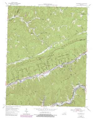
Nolansburg Topo Map Kentucky
To zoom in, hover over the map of Nolansburg
USGS Topo Quad 36083h2 - 1:24,000 scale
| Topo Map Name: | Nolansburg |
| USGS Topo Quad ID: | 36083h2 |
| Print Size: | ca. 21 1/4" wide x 27" high |
| Southeast Coordinates: | 36.875° N latitude / 83.125° W longitude |
| Map Center Coordinates: | 36.9375° N latitude / 83.1875° W longitude |
| U.S. State: | KY |
| Filename: | o36083h2.jpg |
| Download Map JPG Image: | Nolansburg topo map 1:24,000 scale |
| Map Type: | Topographic |
| Topo Series: | 7.5´ |
| Map Scale: | 1:24,000 |
| Source of Map Images: | United States Geological Survey (USGS) |
| Alternate Map Versions: |
Nolansburg KY 1954, updated 1956 Download PDF Buy paper map Nolansburg KY 1954, updated 1966 Download PDF Buy paper map Nolansburg KY 1954, updated 1977 Download PDF Buy paper map Nolansburg KY 1954, updated 1978 Download PDF Buy paper map Nolansburg KY 2011 Download PDF Buy paper map Nolansburg KY 2013 Download PDF Buy paper map Nolansburg KY 2016 Download PDF Buy paper map |
| FStopo: | US Forest Service topo Nolansburg is available: Download FStopo PDF Download FStopo TIF |
1:24,000 Topo Quads surrounding Nolansburg
> Back to 36083e1 at 1:100,000 scale
> Back to 36082a1 at 1:250,000 scale
> Back to U.S. Topo Maps home
Nolansburg topo map: Gazetteer
Nolansburg: Airports
Harlan Airport elevation 390m 1279′Nolansburg: Flats
Cote Bottom elevation 407m 1335′Nolansburg: Forests
Kentenia State Forest elevation 681m 2234′Nolansburg: Gaps
Backbone Rock Gap elevation 612m 2007′Clover Gap elevation 599m 1965′
Jacks Gap elevation 843m 2765′
Shell Gap elevation 793m 2601′
Nolansburg: Populated Places
Arthur elevation 511m 1676′Bailey Creek elevation 423m 1387′
Benito elevation 427m 1400′
Big Laurel elevation 407m 1335′
Colts elevation 420m 1377′
Dillon elevation 392m 1286′
Divide elevation 594m 1948′
Gano elevation 425m 1394′
Laden elevation 394m 1292′
Nolansburg elevation 393m 1289′
Pine Mountain elevation 532m 1745′
Putney elevation 383m 1256′
Ridgeway elevation 429m 1407′
River Ridge elevation 412m 1351′
Shields elevation 427m 1400′
Short Town elevation 412m 1351′
Nolansburg: Post Offices
Benito Post Office (historical) elevation 425m 1394′Dillon Post Office (historical) elevation 383m 1256′
Jonesburg Post Office (historical) elevation 525m 1722′
Kellioka Post Office (historical) elevation 397m 1302′
Laden Post Office (historical) elevation 389m 1276′
Lejunior Post Office elevation 425m 1394′
Lewis Post Office (historical) elevation 380m 1246′
Pine Mountain Post Office (historical) elevation 537m 1761′
Sandvale Post Office (historical) elevation 400m 1312′
Short Town Post Office (historical) elevation 414m 1358′
Splint Post Office (historical) elevation 393m 1289′
Nolansburg: Streams
Abner Branch elevation 458m 1502′Alecs Branch elevation 398m 1305′
Arches Branch elevation 508m 1666′
Bailey Branch elevation 419m 1374′
Ball Branch elevation 373m 1223′
Bear Branch elevation 386m 1266′
Big Branch elevation 396m 1299′
Big Laurel Creek elevation 401m 1315′
Bullhorn Branch elevation 487m 1597′
Chads Branch elevation 384m 1259′
Chumney Branch elevation 398m 1305′
Clover Gap Branch elevation 395m 1295′
Combs Fork elevation 554m 1817′
Crackstill Branch elevation 402m 1318′
Deadening Branch elevation 433m 1420′
Deep Branch elevation 372m 1220′
Dry Branch elevation 433m 1420′
Dry Branch elevation 391m 1282′
Henry Branch elevation 385m 1263′
Hi Lewis Branch elevation 377m 1236′
Holcomb Branch elevation 386m 1266′
Horse Fork elevation 440m 1443′
Huff Branch elevation 409m 1341′
Isaac Creek elevation 530m 1738′
Jacks Branch elevation 393m 1289′
Kelly Branch elevation 420m 1377′
Kelly Branch Clover Fork elevation 423m 1387′
Lakey Branch elevation 385m 1263′
Left Fork Bailey Creek elevation 423m 1387′
Lefthand Fork elevation 434m 1423′
Lick Branch elevation 388m 1272′
Lick Fork elevation 536m 1758′
Liges Branch elevation 416m 1364′
Little Laurel Creek elevation 465m 1525′
Lobster Branch elevation 390m 1279′
Long Branch elevation 541m 1774′
Lower Hannah Branch elevation 383m 1256′
Mill Branch elevation 402m 1318′
Mill Branch elevation 372m 1220′
Mill Cliff Branch elevation 374m 1227′
Mud Ridge Branch elevation 395m 1295′
Nick Branch elevation 512m 1679′
Powell Branch elevation 378m 1240′
Puncheoncamp Branch elevation 493m 1617′
Right Fork Little Laurel Creek elevation 486m 1594′
Rockhouse Creek elevation 382m 1253′
Sang Branch elevation 385m 1263′
Shell Branch elevation 390m 1279′
Short Fork elevation 568m 1863′
Short Fork elevation 393m 1289′
Spruce Ridge Branch elevation 376m 1233′
Station Branch elevation 390m 1279′
Steel Trap Branch elevation 563m 1847′
Stillhouse Branch elevation 380m 1246′
Straight Branch elevation 393m 1289′
Turkey Fork elevation 525m 1722′
Turkeypen Branch elevation 402m 1318′
Upper Hannah Branch elevation 390m 1279′
White Oak Branch elevation 514m 1686′
Wilson Branch elevation 371m 1217′
Winding Branch elevation 511m 1676′
Youngs Branch elevation 487m 1597′
Nolansburg: Summits
Rebels Rock elevation 559m 1833′Nolansburg: Valleys
Double Hollow elevation 408m 1338′Greasy Hollow elevation 586m 1922′
Nolansburg digital topo map on disk
Buy this Nolansburg topo map showing relief, roads, GPS coordinates and other geographical features, as a high-resolution digital map file on DVD:
Western Virginia & Southern West Virginia
Buy digital topo maps: Western Virginia & Southern West Virginia


