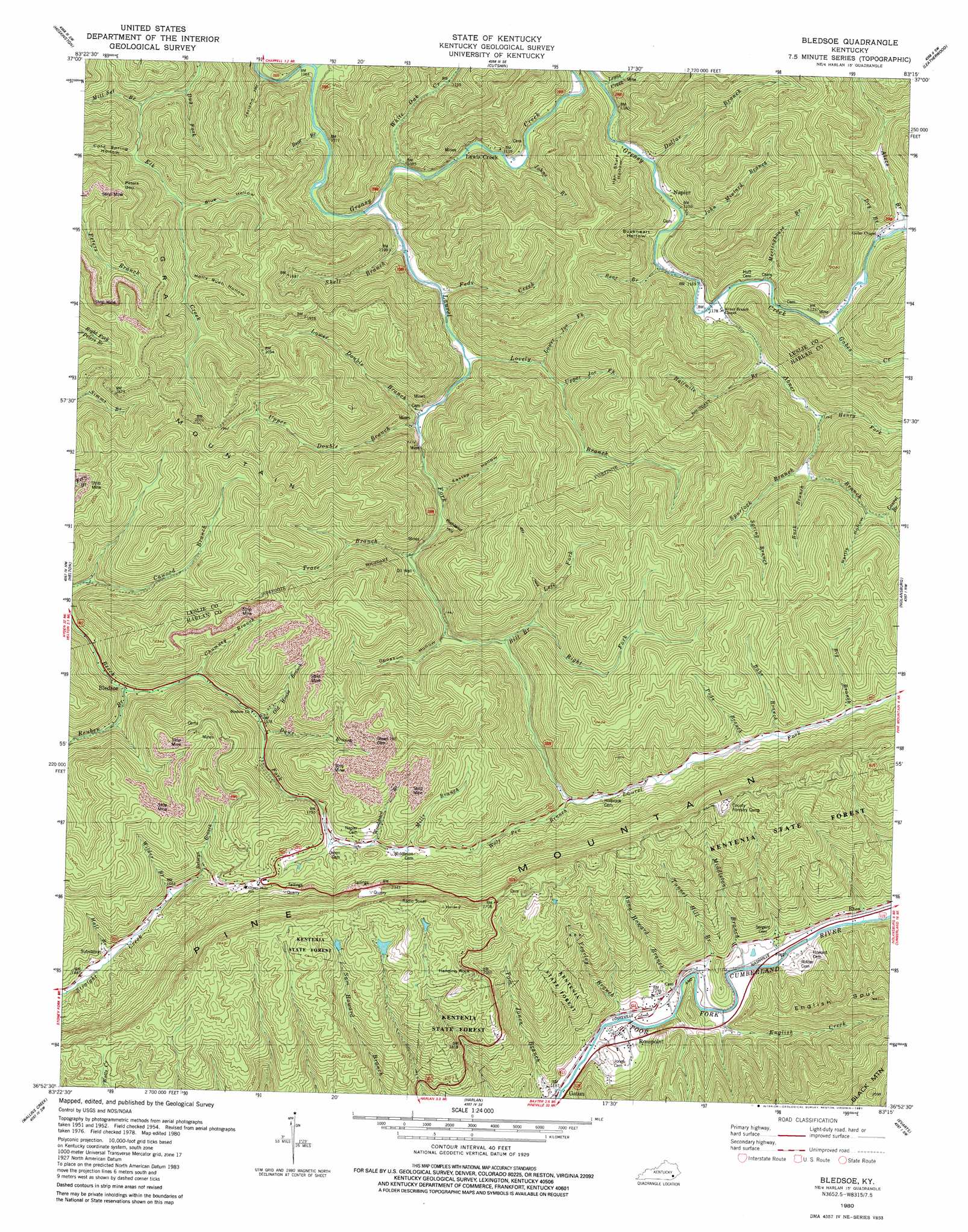
Bledsoe Topo Map Kentucky
To zoom in, hover over the map of Bledsoe
USGS Topo Quad 36083h3 - 1:24,000 scale
| Topo Map Name: | Bledsoe |
| USGS Topo Quad ID: | 36083h3 |
| Print Size: | ca. 21 1/4" wide x 27" high |
| Southeast Coordinates: | 36.875° N latitude / 83.25° W longitude |
| Map Center Coordinates: | 36.9375° N latitude / 83.3125° W longitude |
| U.S. State: | KY |
| Filename: | o36083h3.jpg |
| Download Map JPG Image: | Bledsoe topo map 1:24,000 scale |
| Map Type: | Topographic |
| Topo Series: | 7.5´ |
| Map Scale: | 1:24,000 |
| Source of Map Images: | United States Geological Survey (USGS) |
| Alternate Map Versions: |
Bledsoe KY 1954, updated 1955 Download PDF Buy paper map Bledsoe KY 1954, updated 1967 Download PDF Buy paper map Bledsoe KY 1954, updated 1976 Download PDF Buy paper map Bledsoe KY 1980, updated 1981 Download PDF Buy paper map Bledsoe KY 2011 Download PDF Buy paper map Bledsoe KY 2013 Download PDF Buy paper map Bledsoe KY 2016 Download PDF Buy paper map |
| FStopo: | US Forest Service topo Bledsoe is available: Download FStopo PDF Download FStopo TIF |
1:24,000 Topo Quads surrounding Bledsoe
Big Creek |
Hyden West |
Hyden East |
Hazard South |
Vicco |
Creekville |
Hoskinston |
Cutshin |
Leatherwood |
Tilford |
Beverly |
Helton |
Bledsoe |
Nolansburg |
Louellen |
Balkan |
Wallins Creek |
Harlan |
Evarts |
Pennington Gap |
Varilla |
Ewing |
Rose Hill |
Hubbard Springs |
Ben Hur |
> Back to 36083e1 at 1:100,000 scale
> Back to 36082a1 at 1:250,000 scale
> Back to U.S. Topo Maps home
Bledsoe topo map: Gazetteer
Bledsoe: Flats
Chestnut Flats elevation 425m 1394′Bledsoe: Gaps
Hazard Gap elevation 716m 2349′Peters Gap elevation 497m 1630′
Bledsoe: Pillars
Hanging Rock elevation 743m 2437′Bledsoe: Populated Places
Bledsoe elevation 432m 1417′Lewis Creek elevation 337m 1105′
Napier elevation 349m 1145′
Rhea elevation 382m 1253′
Rosspoint elevation 372m 1220′
Upper Laurel Fork elevation 387m 1269′
Bledsoe: Post Offices
Big Rock Post Office (historical) elevation 452m 1482′Bledsoe Post Office (historical) elevation 441m 1446′
Della Post Office (historical) elevation 388m 1272′
Incline Post Office (historical) elevation 487m 1597′
Jonesburg Post Office (historical) elevation 446m 1463′
Lewis Creek Post Office (historical) elevation 341m 1118′
Napier Post Office (historical) elevation 348m 1141′
Rosspoint Post Office (historical) elevation 365m 1197′
Shell Post Office (historical) elevation 360m 1181′
Templeton Post Office (historical) elevation 357m 1171′
Bledsoe: Ridges
English Spur elevation 712m 2335′Bledsoe: Streams
Abner Branch elevation 359m 1177′Alecs Branch elevation 376m 1233′
Anna Howard Branch elevation 363m 1190′
Babs Branch elevation 510m 1673′
Bear Branch elevation 321m 1053′
Bear Branch elevation 358m 1174′
Betseys Branch elevation 521m 1709′
Big Branch elevation 511m 1676′
Bill Branch elevation 441m 1446′
Britton Branch elevation 324m 1062′
Buck Branch elevation 436m 1430′
Chumney Branch elevation 454m 1489′
Daws Branch elevation 486m 1594′
Dollar Branch elevation 348m 1141′
Dry Branch elevation 378m 1240′
Dug Fork elevation 340m 1115′
English Creek elevation 368m 1207′
Fate Fork elevation 575m 1886′
Feds Creek elevation 340m 1115′
Gabes Creek elevation 369m 1210′
Gap Branch elevation 363m 1190′
Halfmile Branch elevation 378m 1240′
Hall Branch elevation 458m 1502′
Henry Fork elevation 409m 1341′
John Miniard Branch elevation 350m 1148′
Johns Branch elevation 343m 1125′
Laurel Branch elevation 509m 1669′
Laurel Fork elevation 328m 1076′
Left Fork Bill Branch elevation 464m 1522′
Lewis Creek elevation 342m 1122′
Lovely Branch elevation 349m 1145′
Lower Double Branch elevation 361m 1184′
Lower Joe Fork elevation 388m 1272′
Meetinghouse Branch elevation 362m 1187′
Middle Fork Reuben Branch elevation 479m 1571′
Middleton Branch elevation 365m 1197′
Mill Set Branch elevation 352m 1154′
Mills Branch elevation 545m 1788′
Old House Branch elevation 481m 1578′
Pods Branch elevation 504m 1653′
Reuben Branch elevation 434m 1423′
Right Fork Bill Branch elevation 464m 1522′
Shell Branch elevation 332m 1089′
Spring Branch elevation 486m 1594′
Spurlock Branch elevation 426m 1397′
Tom Jones Branch elevation 362m 1187′
Trace Branch elevation 401m 1315′
Tunnel Hill Branch elevation 362m 1187′
Upper Double Branch elevation 361m 1184′
Upper Joe Fork elevation 413m 1354′
White Oak Creek elevation 326m 1069′
Wilder Branch elevation 491m 1610′
Wolf Pen Branch elevation 486m 1594′
Woodward Branch elevation 558m 1830′
Yearley Branch elevation 365m 1197′
Bledsoe: Summits
Gray Mountain elevation 550m 1804′Bledsoe: Trails
Little Sheppard Trail elevation 810m 2657′Bledsoe: Valleys
Blue Hollow elevation 390m 1279′Buckheart Hollow elevation 367m 1204′
Cold Spring Hollow elevation 375m 1230′
Eastep Hollow elevation 382m 1253′
Hen Shate Hollow elevation 356m 1167′
Holly Bush Hollow elevation 423m 1387′
Jericho Hollow elevation 326m 1069′
Nettle Hollow elevation 505m 1656′
Opossum Hollow elevation 429m 1407′
Richland Hollow elevation 388m 1272′
Bledsoe digital topo map on disk
Buy this Bledsoe topo map showing relief, roads, GPS coordinates and other geographical features, as a high-resolution digital map file on DVD:
Western Virginia & Southern West Virginia
Buy digital topo maps: Western Virginia & Southern West Virginia