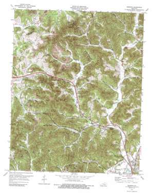
Heidrick Topo Map Kentucky
To zoom in, hover over the map of Heidrick
USGS Topo Quad 36083h8 - 1:24,000 scale
| Topo Map Name: | Heidrick |
| USGS Topo Quad ID: | 36083h8 |
| Print Size: | ca. 21 1/4" wide x 27" high |
| Southeast Coordinates: | 36.875° N latitude / 83.875° W longitude |
| Map Center Coordinates: | 36.9375° N latitude / 83.9375° W longitude |
| U.S. State: | KY |
| Filename: | o36083h8.jpg |
| Download Map JPG Image: | Heidrick topo map 1:24,000 scale |
| Map Type: | Topographic |
| Topo Series: | 7.5´ |
| Map Scale: | 1:24,000 |
| Source of Map Images: | United States Geological Survey (USGS) |
| Alternate Map Versions: |
Heidrick KY 1952, updated 1953 Download PDF Buy paper map Heidrick KY 1952, updated 1972 Download PDF Buy paper map Heidrick KY 1974, updated 1975 Download PDF Buy paper map Heidrick KY 1974, updated 1989 Download PDF Buy paper map Heidrick KY 2010 Download PDF Buy paper map Heidrick KY 2013 Download PDF Buy paper map Heidrick KY 2016 Download PDF Buy paper map |
1:24,000 Topo Quads surrounding Heidrick
> Back to 36083e1 at 1:100,000 scale
> Back to 36082a1 at 1:250,000 scale
> Back to U.S. Topo Maps home
Heidrick topo map: Gazetteer
Heidrick: Gaps
Cooley Gap elevation 363m 1190′Tubhandle Gap elevation 386m 1266′
Heidrick: Mines
Bertha Mine (historical) elevation 340m 1115′Heidrick: Populated Places
Arkle elevation 345m 1131′Crane Nest elevation 312m 1023′
Emanuel elevation 305m 1000′
Heidrick elevation 305m 1000′
Rossland elevation 341m 1118′
Heidrick: Post Offices
Baileys Switch Post Office (historical) elevation 297m 974′Bertha Post Office (historical) elevation 342m 1122′
Charlton Post Office (historical) elevation 347m 1138′
Crane Nest Post Office (historical) elevation 311m 1020′
Emanuel Post Office (historical) elevation 304m 997′
Garrich Post Office (historical) elevation 318m 1043′
Heidrick Post Office elevation 302m 990′
Jarvis Post Office (historical) elevation 303m 994′
Knox Fork Post Office (historical) elevation 326m 1069′
Rossland Post Office (historical) elevation 341m 1118′
Heidrick: Streams
Asher Branch elevation 297m 974′Bailey Branch elevation 298m 977′
Bennett Branch elevation 296m 971′
Cooley Branch elevation 305m 1000′
Crook Branch elevation 312m 1023′
Dozier Fork elevation 295m 967′
Elam Branch elevation 293m 961′
Elliott Branch elevation 302m 990′
Heifer Creek elevation 353m 1158′
Higgins Branch elevation 311m 1020′
Hubbard Branch elevation 305m 1000′
Hunting Shirt Branch elevation 305m 1000′
Jarvis Branch elevation 296m 971′
Knox Fork elevation 297m 974′
Little Richland Creek elevation 293m 961′
Lynn Camp Branch elevation 341m 1118′
Middle Fork Richland Creek elevation 293m 961′
Morris Branch elevation 308m 1010′
Owens Branch elevation 302m 990′
Perry Jarvis Branch elevation 303m 994′
Poplar Branch elevation 303m 994′
Quillan Branch elevation 308m 1010′
Rock House Branch elevation 370m 1213′
Scott Branch elevation 306m 1003′
Scratch Ankle Branch elevation 293m 961′
Stone Cove Branch elevation 303m 994′
Stringer Branch elevation 319m 1046′
Wilson Branch elevation 298m 977′
Heidrick: Summits
Gillam Hill elevation 447m 1466′Gillam Knob elevation 495m 1624′
Kirby Mountain elevation 514m 1686′
Paint Hill elevation 394m 1292′
Poplar Flat elevation 442m 1450′
Tunnel Hill elevation 322m 1056′
Heidrick: Valleys
Bertha Hollow elevation 338m 1108′Booger Hollow elevation 305m 1000′
California Hollow elevation 300m 984′
Demps Hollow elevation 299m 980′
Dyer Hollow elevation 293m 961′
Foley Hollow elevation 345m 1131′
Gozey Hollow elevation 338m 1108′
Hog Hollow elevation 310m 1017′
Horse Hollow elevation 298m 977′
Johnson Hollow elevation 340m 1115′
Owens Hollow elevation 297m 974′
Owens Hollow elevation 307m 1007′
Parrott Hollow elevation 299m 980′
Red Worm Hollow elevation 314m 1030′
Reese Hollow elevation 311m 1020′
Heidrick digital topo map on disk
Buy this Heidrick topo map showing relief, roads, GPS coordinates and other geographical features, as a high-resolution digital map file on DVD:
Western Virginia & Southern West Virginia
Buy digital topo maps: Western Virginia & Southern West Virginia


