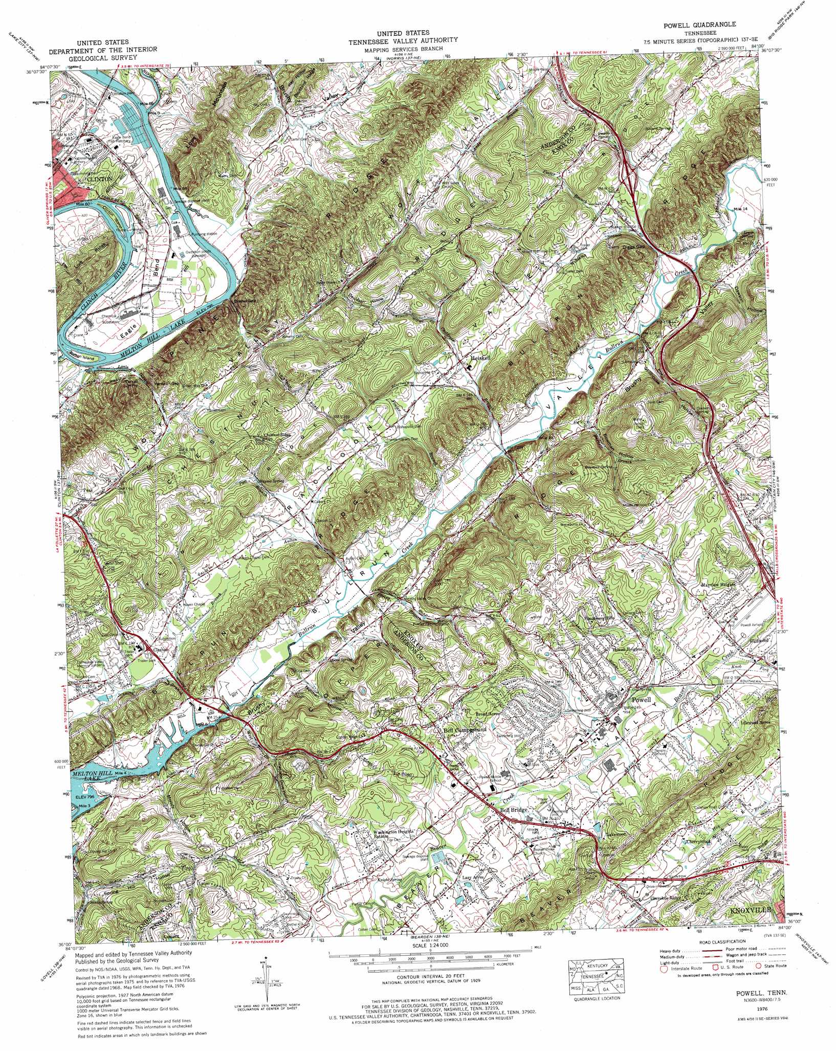
Powell Topo Map Tennessee
To zoom in, hover over the map of Powell
USGS Topo Quad 36084a1 - 1:24,000 scale
| Topo Map Name: | Powell |
| USGS Topo Quad ID: | 36084a1 |
| Print Size: | ca. 21 1/4" wide x 27" high |
| Southeast Coordinates: | 36° N latitude / 84° W longitude |
| Map Center Coordinates: | 36.0625° N latitude / 84.0625° W longitude |
| U.S. State: | TN |
| Filename: | o36084a1.jpg |
| Download Map JPG Image: | Powell topo map 1:24,000 scale |
| Map Type: | Topographic |
| Topo Series: | 7.5´ |
| Map Scale: | 1:24,000 |
| Source of Map Images: | United States Geological Survey (USGS) |
| Alternate Map Versions: |
Powell Station TN 1936 Download PDF Buy paper map Powell Station TN 1941 Download PDF Buy paper map Powell Station TN 1941, updated 1952 Download PDF Buy paper map Powell TN 1952, updated 1955 Download PDF Buy paper map Powell TN 1952, updated 1961 Download PDF Buy paper map Powell TN 1968, updated 1971 Download PDF Buy paper map Powell TN 1976, updated 1977 Download PDF Buy paper map Powell TN 1976, updated 1977 Download PDF Buy paper map Powell TN 2010 Download PDF Buy paper map Powell TN 2013 Download PDF Buy paper map Powell TN 2016 Download PDF Buy paper map |
1:24,000 Topo Quads surrounding Powell
Block |
Jacksboro |
Demory |
White Hollow |
Maynardville |
Duncan Flats |
Lake City |
Norris |
Big Ridge Park |
Graveston |
Windrock |
Clinton |
Powell |
Fountain City |
John Sevier |
Bethel Valley |
Lovell |
Bearden |
Knoxville |
Shooks Gap |
Lenoir City |
Concord |
Louisville |
Maryville |
Wildwood |
> Back to 36084a1 at 1:100,000 scale
> Back to 36084a1 at 1:250,000 scale
> Back to U.S. Topo Maps home
Powell topo map: Gazetteer
Powell: Airports
Clinton Landing Field (historical) elevation 256m 839′Powell Airport elevation 302m 990′
Powell: Bars
Clinton Island Shoals elevation 242m 793′Cummings Island Shoals elevation 242m 793′
Hines Creek Shoals elevation 242m 793′
Youngs Shoals elevation 242m 793′
Powell: Bends
Eagle Bend elevation 253m 830′Eagle Bend elevation 256m 839′
Powell: Bridges
Moore Bridge elevation 242m 793′Powell: Crossings
Interchange 112 elevation 305m 1000′Interchange 117 elevation 286m 938′
Moore Ferry (historical) elevation 242m 793′
Moores Ford (historical) elevation 242m 793′
Powell: Gaps
Diggs Gap elevation 259m 849′Dismal Gap elevation 247m 810′
Yarnell Gap elevation 264m 866′
Powell: Islands
Aulton Island elevation 246m 807′Clinton Island elevation 244m 800′
Powell: Parks
Brushy Valley Park elevation 248m 813′Eagle Bend Public Access Area elevation 243m 797′
Powell Park elevation 302m 990′
Powell: Populated Places
Bell Bridge elevation 300m 984′Broad Acres elevation 340m 1115′
Bull Run elevation 251m 823′
Cherokee Ridge elevation 366m 1200′
Cherrybrook elevation 331m 1085′
Claxton elevation 259m 849′
Cumberland View Mobile Home Park elevation 349m 1145′
Deep Springs elevation 263m 862′
Glenwood elevation 304m 997′
Grand Oaks elevation 345m 1131′
Heiskell elevation 268m 879′
Idlewood Acres elevation 309m 1013′
Lakewood elevation 320m 1049′
Lazy Acres elevation 298m 977′
Mayview Heights elevation 325m 1066′
Northhampton Acres elevation 317m 1040′
Peak elevation 283m 928′
Ponderosa Hills elevation 354m 1161′
Powell elevation 304m 997′
Powell Heights elevation 333m 1092′
Shadow Wood elevation 307m 1007′
Sites Mobile Home Park elevation 327m 1072′
Spring Hill elevation 250m 820′
Treeville elevation 297m 974′
Twi-lite Zone Mobile Home Park elevation 330m 1082′
Washington Heights elevation 324m 1062′
Powell: Post Offices
Heiskell Post Office elevation 268m 879′Powell Post Office elevation 314m 1030′
Powell: Ridges
Bullrun Ridge elevation 374m 1227′Chestnut Ridge elevation 311m 1020′
Flint Ridge elevation 343m 1125′
Powell: Springs
Bowman Spring elevation 292m 958′Conner Spring elevation 309m 1013′
Fowler Spring elevation 274m 898′
Gamble Spring elevation 277m 908′
Gill Spring elevation 303m 994′
Haynes Spring elevation 281m 921′
Holbert Spring elevation 285m 935′
Knight Spring elevation 297m 974′
Lewis Spring elevation 271m 889′
Moore Spring elevation 258m 846′
Sands Spring elevation 262m 859′
Yarnell Spring elevation 255m 836′
Powell: Streams
Aulton Branch elevation 246m 807′Blazer Branch elevation 253m 830′
Burnett Branch elevation 253m 830′
Childress Branch elevation 250m 820′
Copper Ridge Branch elevation 254m 833′
Davison Spring Branch elevation 268m 879′
Dismal Creek elevation 252m 826′
Dooling Spring Branch elevation 255m 836′
Foster Branch elevation 267m 875′
Fowler Branch elevation 248m 813′
Fowler Spring Branch elevation 245m 803′
Grassy Creek elevation 321m 1053′
Hinds Creek elevation 252m 826′
Jennings Branch elevation 242m 793′
Knob Fork elevation 298m 977′
Little Dismal Creek elevation 242m 793′
Moore Branch elevation 286m 938′
Nelson Branch elevation 246m 807′
Patt Branch elevation 254m 833′
West Branch Bull Run Creek elevation 244m 800′
Whitcox Branch elevation 293m 961′
Williams Branch elevation 254m 833′
Powell: Valleys
Bowman Hollow elevation 268m 879′Brushy Valley elevation 254m 833′
Bullrun Valley elevation 242m 793′
Davidson Hollow elevation 289m 948′
Dawson Hollow elevation 256m 839′
Lonesome Dove Hollow elevation 262m 859′
Moody Hollow elevation 249m 816′
Norman Hollow elevation 244m 800′
Ray Hollow elevation 279m 915′
Spring Hill Hollow elevation 255m 836′
Stillhouse Hollow elevation 256m 839′
Powell digital topo map on disk
Buy this Powell topo map showing relief, roads, GPS coordinates and other geographical features, as a high-resolution digital map file on DVD: