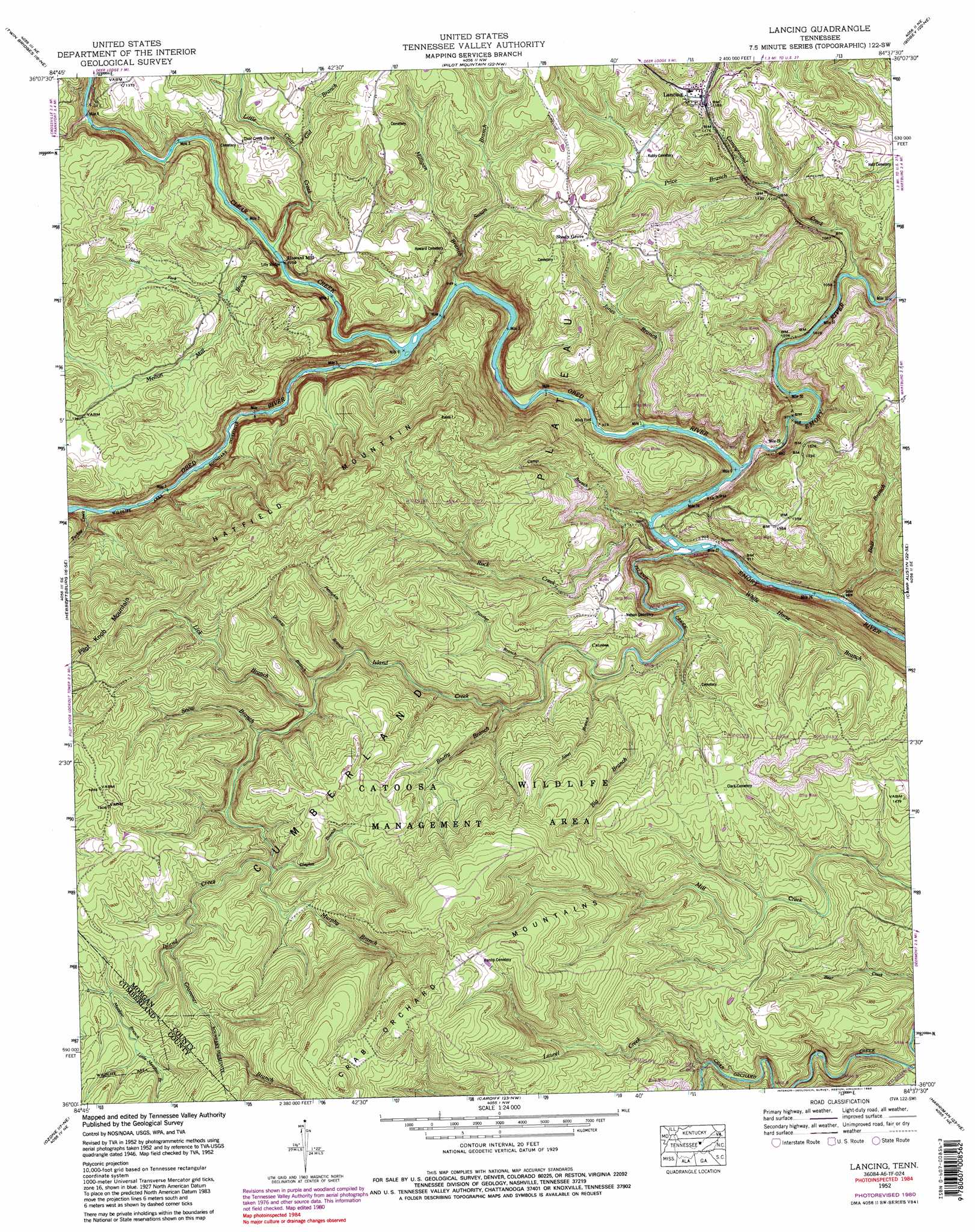
Lancing Topo Map Tennessee
To zoom in, hover over the map of Lancing
USGS Topo Quad 36084a6 - 1:24,000 scale
| Topo Map Name: | Lancing |
| USGS Topo Quad ID: | 36084a6 |
| Print Size: | ca. 21 1/4" wide x 27" high |
| Southeast Coordinates: | 36° N latitude / 84.625° W longitude |
| Map Center Coordinates: | 36.0625° N latitude / 84.6875° W longitude |
| U.S. State: | TN |
| Filename: | o36084a6.jpg |
| Download Map JPG Image: | Lancing topo map 1:24,000 scale |
| Map Type: | Topographic |
| Topo Series: | 7.5´ |
| Map Scale: | 1:24,000 |
| Source of Map Images: | United States Geological Survey (USGS) |
| Alternate Map Versions: |
Lancing TN 1935 Download PDF Buy paper map Lancing TN 1946, updated 1948 Download PDF Buy paper map Lancing TN 1952, updated 1955 Download PDF Buy paper map Lancing TN 1952, updated 1967 Download PDF Buy paper map Lancing TN 1952, updated 1974 Download PDF Buy paper map Lancing TN 1952, updated 1980 Download PDF Buy paper map Lancing TN 1952, updated 1988 Download PDF Buy paper map Lancing TN 1952, updated 1988 Download PDF Buy paper map Lancing TN 2010 Download PDF Buy paper map Lancing TN 2013 Download PDF Buy paper map Lancing TN 2016 Download PDF Buy paper map |
1:24,000 Topo Quads surrounding Lancing
Grimsley |
Burrville |
Rugby |
Robbins |
Norma |
Jones Knob |
Twin Bridges |
Pilot Mountain |
Gobey |
Fork Mountain |
Fox Creek |
Hebbertsburg |
Lancing |
Camp Austin |
Petros |
Dorton |
Ozone |
Cardiff |
Harriman |
Elverton |
Grassy Cove |
Roddy |
Rockwood |
Bacon Gap |
Cave Creek |
> Back to 36084a1 at 1:100,000 scale
> Back to 36084a1 at 1:250,000 scale
> Back to U.S. Topo Maps home
Lancing topo map: Gazetteer
Lancing: Bridges
Jett Bridge elevation 337m 1105′Lilly Bridge elevation 318m 1043′
Nemo Bridge elevation 259m 849′
Lancing: Crossings
Alley Ford elevation 273m 895′Lancing: Falls
Jacks Rock Falls elevation 318m 1043′Lancing: Populated Places
Catoosa elevation 353m 1158′Howard Mill elevation 322m 1056′
Lancing elevation 362m 1187′
Nemo elevation 279m 915′
Ruppe (historical) elevation 482m 1581′
Shady Grove elevation 422m 1384′
Lancing: Post Offices
Lancing Post Office elevation 363m 1190′Lancing: Rapids
Camel Rock Rapids elevation 308m 1010′Canoe Hole Rapids elevation 288m 944′
Lilly Rapids elevation 314m 1030′
Nemo Rapids elevation 258m 846′
Ohmigod Rapids elevation 307m 1007′
Rock Garden Rapids elevation 301m 987′
The Grunch Rapids elevation 325m 1066′
Widow Maker Rapids elevation 275m 902′
Wootens Folly Rapids elevation 303m 994′
Lancing: Streams
Bear Branch elevation 252m 826′Big Branch elevation 377m 1236′
Bluffy Branch elevation 365m 1197′
Camp Branch elevation 285m 935′
Campground Creek elevation 295m 967′
Chestnut Branch elevation 331m 1085′
Clayton Branch elevation 456m 1496′
Clear Creek elevation 291m 954′
Dismal Branch elevation 404m 1325′
Galbreth Branch elevation 304m 997′
Grammer Branch elevation 480m 1574′
Gut Branch elevation 368m 1207′
Island Creek elevation 257m 843′
Jones Branch elevation 335m 1099′
Jones Branch elevation 270m 885′
Laurel Creek elevation 346m 1135′
Lick Branch elevation 413m 1354′
Little Clear Creek elevation 319m 1046′
Little Meadow Branch elevation 504m 1653′
Meadow Branch elevation 499m 1637′
Melton Mill Branch elevation 314m 1030′
Milligan Branch elevation 291m 954′
Murphy Branch elevation 458m 1502′
North Fork Melton Mill Branch elevation 377m 1236′
Obed River elevation 258m 846′
Panther Branch elevation 350m 1148′
Pennykin Branch elevation 403m 1322′
Price Branch elevation 336m 1102′
Rock Creek elevation 265m 869′
Scott Hickman Spring Branch elevation 339m 1112′
Snow Branch elevation 420m 1377′
Susan Branch elevation 344m 1128′
Turkey Creek elevation 319m 1046′
White Horse Branch elevation 274m 898′
Lancing: Summits
Hatfield Mountain elevation 601m 1971′Lancing digital topo map on disk
Buy this Lancing topo map showing relief, roads, GPS coordinates and other geographical features, as a high-resolution digital map file on DVD: