Norris Topo Map Tennessee
To zoom in, hover over the map of Norris
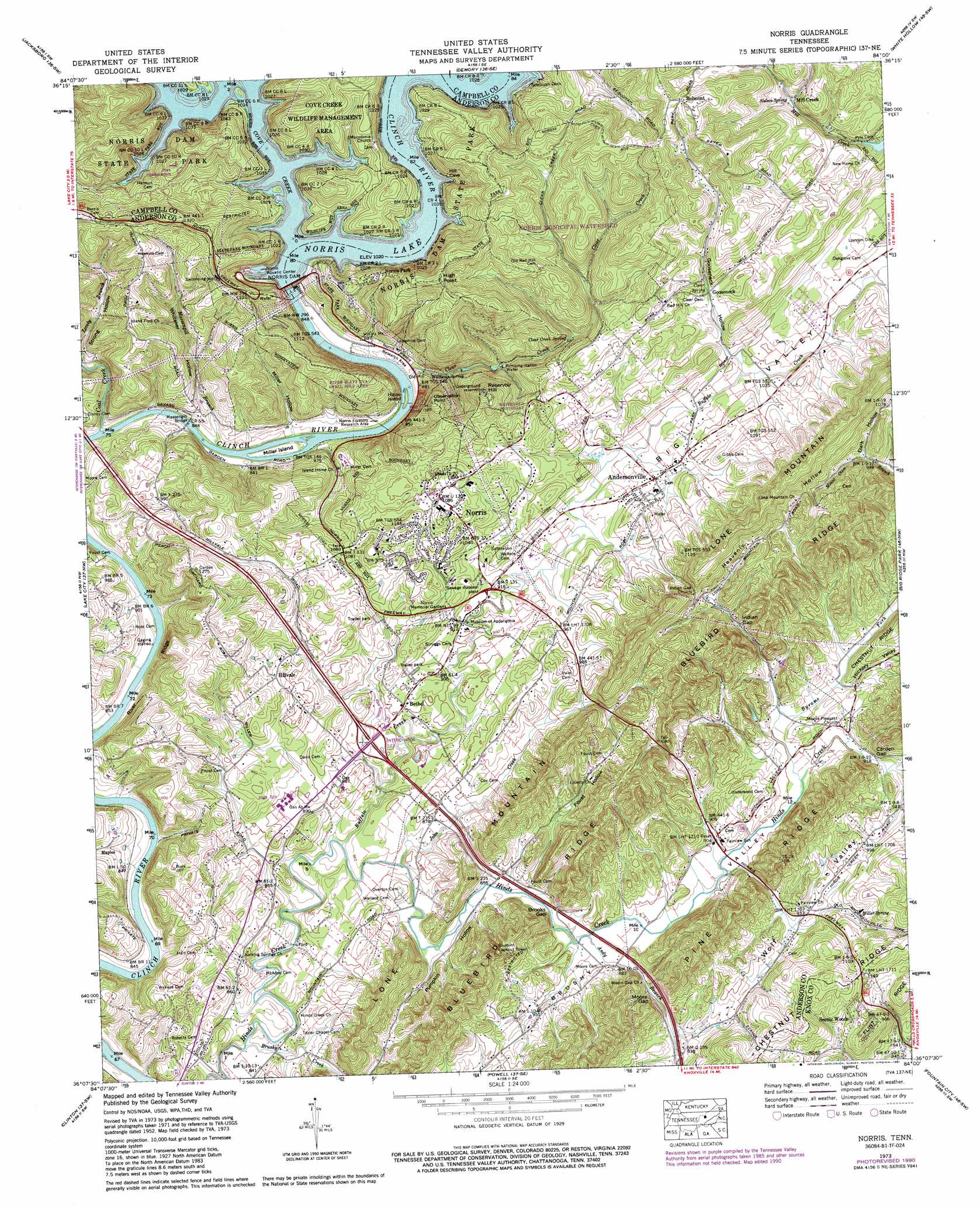
USGS Topo Quad 36084b1 - 1:24,000 scale
| Topo Map Name: | Norris |
| USGS Topo Quad ID: | 36084b1 |
| Print Size: | ca. 21 1/4" wide x 27" high |
| Southeast Coordinates: | 36.125° N latitude / 84° W longitude |
| Map Center Coordinates: | 36.1875° N latitude / 84.0625° W longitude |
| U.S. State: | TN |
| Filename: | o36084b1.jpg |
| Download Map JPG Image: | Norris topo map 1:24,000 scale |
| Map Type: | Topographic |
| Topo Series: | 7.5´ |
| Map Scale: | 1:24,000 |
| Source of Map Images: | United States Geological Survey (USGS) |
| Alternate Map Versions: |
Norris TN 1936 Download PDF Buy paper map Norris TN 1941 Download PDF Buy paper map Norris TN 1941, updated 1950 Download PDF Buy paper map Norris TN 1952, updated 1955 Download PDF Buy paper map Norris TN 1952, updated 1960 Download PDF Buy paper map Norris TN 1952, updated 1966 Download PDF Buy paper map Norris TN 1973, updated 1975 Download PDF Buy paper map Norris TN 1973, updated 1991 Download PDF Buy paper map Norris TN 2010 Download PDF Buy paper map Norris TN 2013 Download PDF Buy paper map Norris TN 2016 Download PDF Buy paper map |
1:24,000 Topo Quads surrounding Norris
Pioneer |
Ivydell |
La Follette |
Well Spring |
Ausmus |
Block |
Jacksboro |
Demory |
White Hollow |
Maynardville |
Duncan Flats |
Lake City |
Norris |
Big Ridge Park |
Graveston |
Windrock |
Clinton |
Powell |
Fountain City |
John Sevier |
Bethel Valley |
Lovell |
Bearden |
Knoxville |
Shooks Gap |
> Back to 36084a1 at 1:100,000 scale
> Back to 36084a1 at 1:250,000 scale
> Back to U.S. Topo Maps home
Norris topo map: Gazetteer
Norris: Bars
Johnsons Shoals elevation 249m 816′Norris: Bridges
Massengill Bridge elevation 248m 813′Norris: Cliffs
River Ridge elevation 283m 928′Norris: Crossings
Interchange 122 elevation 271m 889′Island Ford elevation 249m 816′
Norris: Dams
Norris Dam elevation 261m 856′Norris: Forests
Norris Forestry Research Area elevation 250m 820′Norris Town Forest elevation 366m 1200′
Norris: Gaps
Brooks Gap elevation 262m 859′Carden Gap elevation 281m 921′
Indian Gap elevation 300m 984′
Moore Gap elevation 273m 895′
Norris: Islands
Hibbs Island elevation 249m 816′Miller Island elevation 256m 839′
Norris: Parks
Norris Dam State Park elevation 376m 1233′Norris Municipal Park elevation 328m 1076′
River Bluff Small Wild Area elevation 310m 1017′
Norris: Populated Places
Andersonville elevation 295m 967′Belmont elevation 422m 1384′
Bethel elevation 278m 912′
Gooseneck elevation 318m 1043′
Hillvale elevation 310m 1017′
Hinds Creek (historical) elevation 268m 879′
Ivory elevation 284m 931′
Maples elevation 282m 925′
Mill Creek elevation 340m 1115′
Norris elevation 327m 1072′
Norris Park elevation 362m 1187′
Panther (historical) elevation 287m 941′
Norris: Post Offices
Anderson Post Office elevation 297m 974′Norris: Reservoirs
Norris Lake elevation 261m 856′Norris: Ridges
Bluebird Ridge elevation 398m 1305′Lone Mountain elevation 420m 1377′
Norris: Springs
Clear Creek Spring elevation 301m 987′Clear Spring elevation 317m 1040′
Miller Spring elevation 297m 974′
Nelson Spring elevation 333m 1092′
Williams Spring elevation 268m 879′
Norris: Streams
Andy Branch elevation 262m 859′Brushy Creek elevation 250m 820′
Buffalo Creek elevation 256m 839′
Byrams Fork elevation 272m 892′
Clear Creek elevation 253m 830′
Coal Creek elevation 248m 813′
Cove Creek elevation 311m 1020′
John Creek elevation 256m 839′
Norris: Summits
High Point elevation 439m 1440′Observation Point elevation 417m 1368′
Reservoir Hill elevation 413m 1354′
Norris: Trails
Deer Trail elevation 301m 987′River Bluff Trail elevation 316m 1036′
Norris: Valleys
Big Valley elevation 280m 918′Brushy Valley elevation 250m 820′
Buffalo Valley elevation 278m 912′
Dark Hollow elevation 310m 1017′
Foust Hollow elevation 262m 859′
Gooseneck Hollow elevation 298m 977′
Heavenly Hollow elevation 310m 1017′
Hickory Valley elevation 280m 918′
Massengill Hollow elevation 249m 816′
Miller Hollow elevation 249m 816′
Pumpkin Hollow elevation 261m 856′
Whitaker Hollow elevation 249m 816′
Norris digital topo map on disk
Buy this Norris topo map showing relief, roads, GPS coordinates and other geographical features, as a high-resolution digital map file on DVD: