Duncan Flats Topo Map Tennessee
To zoom in, hover over the map of Duncan Flats
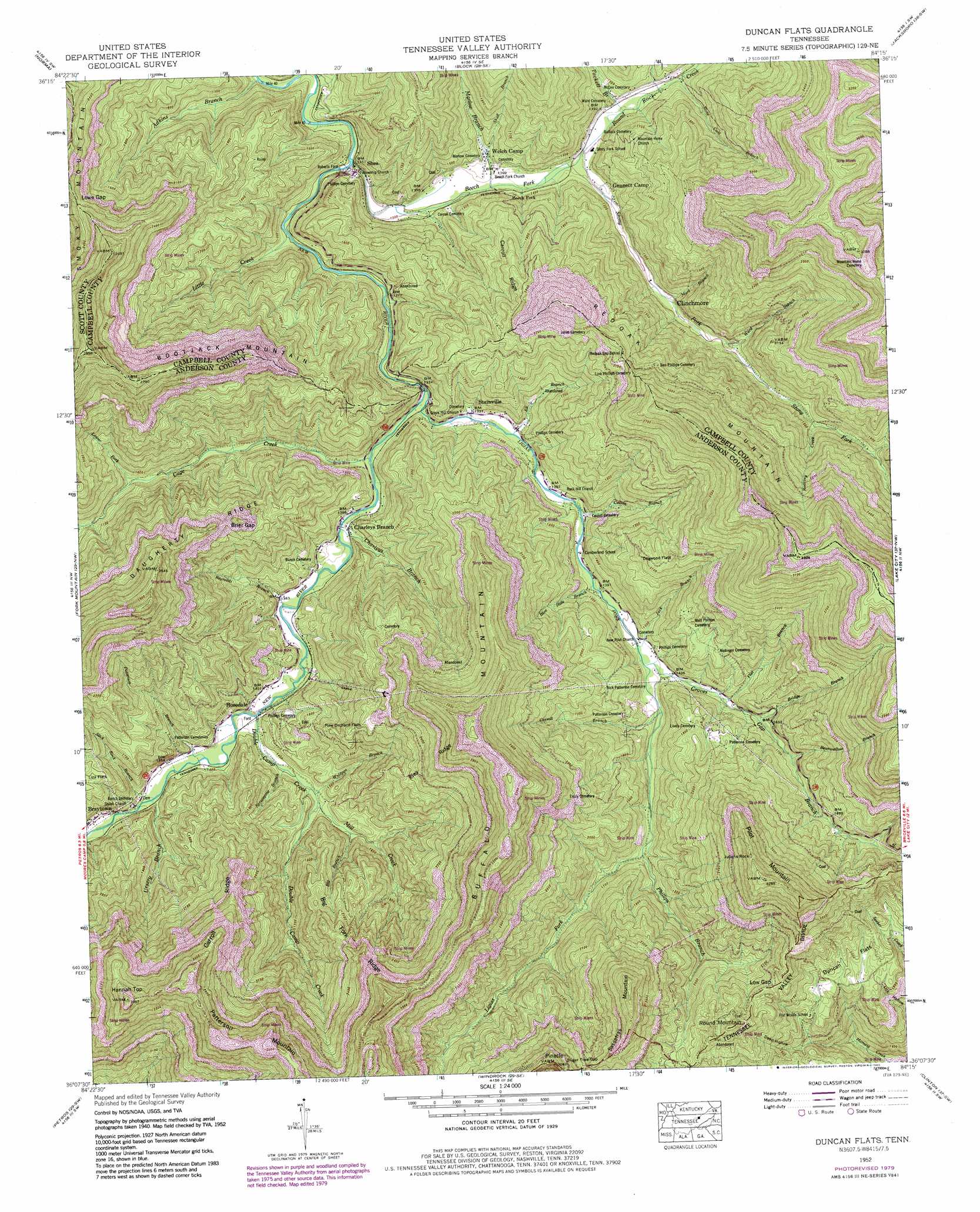
USGS Topo Quad 36084b3 - 1:24,000 scale
| Topo Map Name: | Duncan Flats |
| USGS Topo Quad ID: | 36084b3 |
| Print Size: | ca. 21 1/4" wide x 27" high |
| Southeast Coordinates: | 36.125° N latitude / 84.25° W longitude |
| Map Center Coordinates: | 36.1875° N latitude / 84.3125° W longitude |
| U.S. State: | TN |
| Filename: | o36084b3.jpg |
| Download Map JPG Image: | Duncan Flats topo map 1:24,000 scale |
| Map Type: | Topographic |
| Topo Series: | 7.5´ |
| Map Scale: | 1:24,000 |
| Source of Map Images: | United States Geological Survey (USGS) |
| Alternate Map Versions: |
Duncan Flats TN 1936 Download PDF Buy paper map Duncan Flats TN 1947, updated 1947 Download PDF Buy paper map Duncan Flats TN 1952, updated 1954 Download PDF Buy paper map Duncan Flats TN 1952, updated 1968 Download PDF Buy paper map Duncan Flats TN 1952, updated 1980 Download PDF Buy paper map Duncan Flats TN 1952, updated 1980 Download PDF Buy paper map Duncan Flats TN 1952, updated 1980 Download PDF Buy paper map Duncan Flats TN 2010 Download PDF Buy paper map Duncan Flats TN 2013 Download PDF Buy paper map Duncan Flats TN 2016 Download PDF Buy paper map |
1:24,000 Topo Quads surrounding Duncan Flats
Oneida South |
Huntsville |
Pioneer |
Ivydell |
La Follette |
Robbins |
Norma |
Block |
Jacksboro |
Demory |
Gobey |
Fork Mountain |
Duncan Flats |
Lake City |
Norris |
Camp Austin |
Petros |
Windrock |
Clinton |
Powell |
Harriman |
Elverton |
Bethel Valley |
Lovell |
Bearden |
> Back to 36084a1 at 1:100,000 scale
> Back to 36084a1 at 1:250,000 scale
> Back to U.S. Topo Maps home
Duncan Flats topo map: Gazetteer
Duncan Flats: Crossings
Roberts Ford elevation 389m 1276′Duncan Flats: Flats
Dogwood Flats elevation 661m 2168′Duncan Flats elevation 603m 1978′
Liza Flats elevation 550m 1804′
Pine Orchard Flats elevation 619m 2030′
Duncan Flats: Gaps
Brier Gap elevation 675m 2214′Low Gap elevation 687m 2253′
Lowe Gap elevation 727m 2385′
Sugar Tree Gap elevation 764m 2506′
Duncan Flats: Mines
Bob Elders Mine elevation 472m 1548′Charles Phillips Mine elevation 454m 1489′
Clinchmore Mine elevation 770m 2526′
Diggs Mine elevation 449m 1473′
Dorrycott Mine elevation 736m 2414′
Dory Irish Mine elevation 476m 1561′
Graves Gap Mine elevation 716m 2349′
Issac Lowe Mine elevation 472m 1548′
Jim Braden Mine elevation 526m 1725′
Main Mountain Mine elevation 458m 1502′
Rosedale Two B Mine elevation 713m 2339′
Shafer Mine elevation 759m 2490′
Thompson Mine elevation 812m 2664′
Duncan Flats: Pillars
Pinacle elevation 931m 3054′Duncan Flats: Populated Places
Beech Fork elevation 418m 1371′Braytown elevation 429m 1407′
Charleys Branch elevation 410m 1345′
Clinchmore elevation 444m 1456′
Gennett Camp elevation 418m 1371′
Rosedale elevation 423m 1387′
Shea elevation 396m 1299′
Stainville elevation 405m 1328′
Welch Camp elevation 420m 1377′
Duncan Flats: Ridges
Big Fork Ridge elevation 692m 2270′Carroll Ridge elevation 649m 2129′
Carroll Ridge elevation 847m 2778′
Daugherty Ridge elevation 870m 2854′
Ples Ridge elevation 776m 2545′
Duncan Flats: Streams
Adkins Branch elevation 383m 1256′Bearwallow Branch elevation 494m 1620′
Beech Fork elevation 390m 1279′
Big Branch elevation 451m 1479′
Blue Hole Branch elevation 420m 1377′
Bridge Branch elevation 468m 1535′
Cage Creek elevation 402m 1318′
Calvin Branch elevation 413m 1354′
Carroll Branch elevation 438m 1437′
Charleys Branch elevation 406m 1332′
Double Camp Creek elevation 414m 1358′
East Fork Ligias Creek elevation 469m 1538′
Eli Branch elevation 406m 1332′
Flat Branch elevation 451m 1479′
Graves Gap Branch elevation 430m 1410′
Jack Branch elevation 429m 1407′
Ligias Fork elevation 395m 1295′
Little Creek elevation 395m 1295′
Lower Fork elevation 461m 1512′
Marlow Branch elevation 401m 1315′
Mart Branch elevation 441m 1446′
Mill Creek elevation 438m 1437′
Patterson Branch elevation 418m 1371′
Phillips Branch elevation 475m 1558′
Reynolds Branch elevation 408m 1338′
Roaring Creek elevation 516m 1692′
Round Rock Creek elevation 408m 1338′
Skull Branch elevation 413m 1354′
Slick Rock Branch elevation 419m 1374′
Sprucepine Branch elevation 424m 1391′
Stone Coal Branch elevation 427m 1400′
Stony Fork elevation 408m 1338′
Tackett Branch elevation 415m 1361′
Upper Fork elevation 496m 1627′
Ursery Branch elevation 419m 1374′
Ward Branch elevation 463m 1519′
Wolfpen Branch elevation 435m 1427′
Duncan Flats: Summits
Bootjack Mountain elevation 831m 2726′Buffalo Mountain elevation 1008m 3307′
Hannah Top elevation 963m 3159′
Julians Rock elevation 946m 3103′
Patterson Mountain elevation 984m 3228′
Pilot Mountain elevation 993m 3257′
Redoak Mountain elevation 1027m 3369′
Round Mountain elevation 801m 2627′
Sassafras Mountain elevation 935m 3067′
Duncan Flats: Valleys
Deep Hollow elevation 383m 1256′Duncan Flats digital topo map on disk
Buy this Duncan Flats topo map showing relief, roads, GPS coordinates and other geographical features, as a high-resolution digital map file on DVD: