Fork Mountain Topo Map Tennessee
To zoom in, hover over the map of Fork Mountain
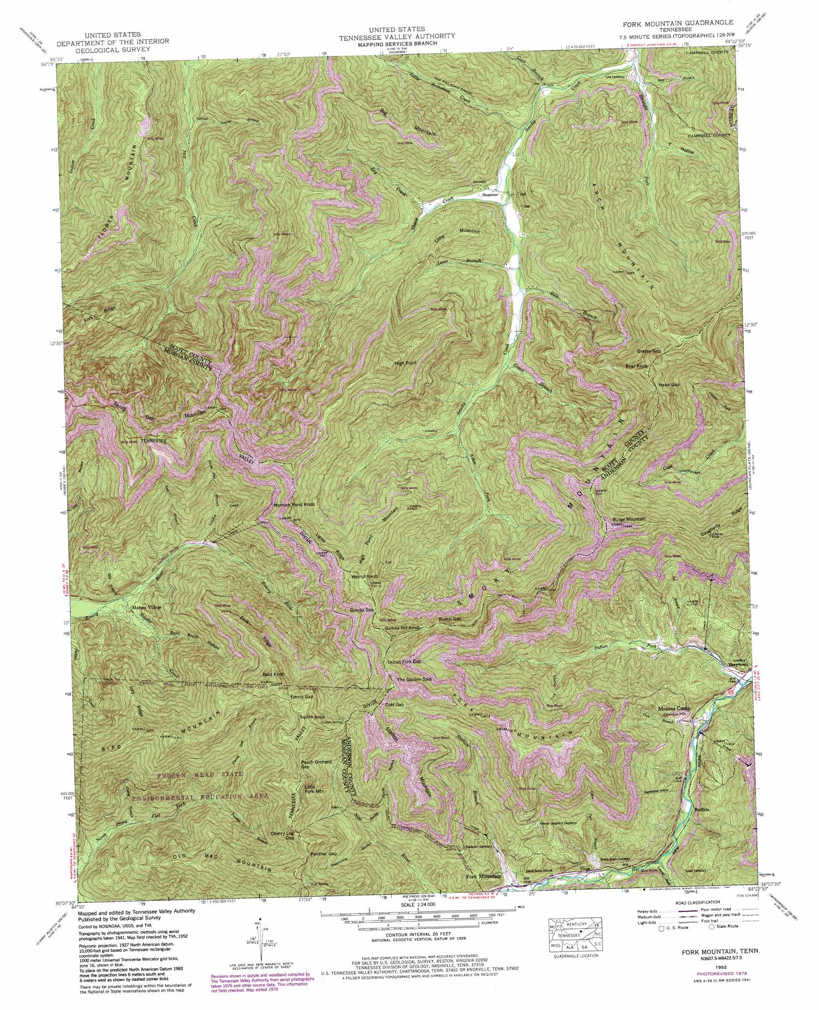
USGS Topo Quad 36084b4 - 1:24,000 scale
| Topo Map Name: | Fork Mountain |
| USGS Topo Quad ID: | 36084b4 |
| Print Size: | ca. 21 1/4" wide x 27" high |
| Southeast Coordinates: | 36.125° N latitude / 84.375° W longitude |
| Map Center Coordinates: | 36.1875° N latitude / 84.4375° W longitude |
| U.S. State: | TN |
| Filename: | o36084b4.jpg |
| Download Map JPG Image: | Fork Mountain topo map 1:24,000 scale |
| Map Type: | Topographic |
| Topo Series: | 7.5´ |
| Map Scale: | 1:24,000 |
| Source of Map Images: | United States Geological Survey (USGS) |
| Alternate Map Versions: |
Hogbell Gap TN 1936 Download PDF Buy paper map Fork Mountain TN 1946, updated 1947 Download PDF Buy paper map Fork Mountain TN 1946, updated 1947 Download PDF Buy paper map Fork Mountain TN 1952, updated 1954 Download PDF Buy paper map Fork Mountain TN 1952, updated 1969 Download PDF Buy paper map Fork Mountain TN 1952, updated 1977 Download PDF Buy paper map Fork Mountain TN 1952, updated 1980 Download PDF Buy paper map Fork Mountain TN 1952, updated 1980 Download PDF Buy paper map Fork Mountain TN 2010 Download PDF Buy paper map Fork Mountain TN 2013 Download PDF Buy paper map Fork Mountain TN 2016 Download PDF Buy paper map |
1:24,000 Topo Quads surrounding Fork Mountain
Honey Creek |
Oneida South |
Huntsville |
Pioneer |
Ivydell |
Rugby |
Robbins |
Norma |
Block |
Jacksboro |
Pilot Mountain |
Gobey |
Fork Mountain |
Duncan Flats |
Lake City |
Lancing |
Camp Austin |
Petros |
Windrock |
Clinton |
Cardiff |
Harriman |
Elverton |
Bethel Valley |
Lovell |
> Back to 36084a1 at 1:100,000 scale
> Back to 36084a1 at 1:250,000 scale
> Back to U.S. Topo Maps home
Fork Mountain topo map: Gazetteer
Fork Mountain: Forests
Morgan State Forest elevation 602m 1975′Fork Mountain: Gaps
Bunch Gap elevation 879m 2883′Cherry Log Gap elevation 895m 2936′
Cold Gap elevation 914m 2998′
Emory Gap elevation 912m 2992′
Grassy Gap elevation 884m 2900′
Guinea Gap elevation 880m 2887′
Hawk Gap elevation 876m 2874′
Indian Fork Gap elevation 877m 2877′
Panther Gap elevation 886m 2906′
Peach Orchard Gap elevation 923m 3028′
Fork Mountain: Mines
Brushy Mountain Number 4 Mine elevation 788m 2585′Brushy Mountain Number 5 Mine elevation 700m 2296′
Brushy Mountain Number 6 Mine elevation 812m 2664′
Chambers Mine elevation 450m 1476′
Darty Mine elevation 488m 1601′
Fork Mountain-Peewee Mountain Mine elevation 787m 2582′
Leonard Mine elevation 458m 1502′
Lindsay Mine elevation 464m 1522′
Mahan-Ellison Mine elevation 835m 2739′
Moore Mine elevation 712m 2335′
Pemberton and Hibble Number One Mine elevation 449m 1473′
Sagamine Mine elevation 697m 2286′
Thompson Number 1 Mine elevation 469m 1538′
Thompson Number 2 Mine elevation 483m 1584′
Trimore Mine elevation 622m 2040′
Fork Mountain: Parks
Frozen Head State Environmental Education Area elevation 797m 2614′Fork Mountain: Populated Places
Buffalo elevation 436m 1430′Fork Mountain elevation 473m 1551′
Hembree elevation 412m 1351′
Mahan Village elevation 397m 1302′
Moores Camp elevation 438m 1437′
Newland (historical) elevation 388m 1272′
Tioga elevation 463m 1519′
Fork Mountain: Post Offices
Devonia Post Office elevation 425m 1394′Fork Mountain: Ridges
Fork Ridge elevation 798m 2618′Jury Ridge elevation 768m 2519′
Ligias Ridge elevation 881m 2890′
Zeek Ridge elevation 860m 2821′
Fork Mountain: Springs
Coffin Spring elevation 888m 2913′Tub Spring elevation 931m 3054′
Fork Mountain: Streams
Alex Branch elevation 418m 1371′Asher Fork elevation 455m 1492′
Barley Mouth Branch elevation 614m 2014′
Big Cove Branch elevation 438m 1437′
Bills Branch elevation 421m 1381′
Cave Branch elevation 401m 1315′
Coon Pool Branch elevation 452m 1482′
Dry Creek elevation 422m 1384′
Emory Gap Branch elevation 516m 1692′
Green Branch elevation 431m 1414′
Gum Branch elevation 426m 1397′
Indian Fork elevation 420m 1377′
Joe Branch elevation 440m 1443′
Laurel Fork elevation 444m 1456′
Lick Branch elevation 484m 1587′
Linlog Branch elevation 450m 1476′
Little Brimstone Creek elevation 405m 1328′
Loudon Creek elevation 428m 1404′
Lowe Branch elevation 421m 1381′
Ova Branch elevation 393m 1289′
Panther Branch elevation 519m 1702′
Rayder Creek elevation 387m 1269′
Second Laurel Branch elevation 425m 1394′
Shack Creek elevation 409m 1341′
Snake Den Branch elevation 425m 1394′
Stallion Branch elevation 472m 1548′
Straight Fork elevation 388m 1272′
Sugarcamp Branch elevation 596m 1955′
Sugarcamp Branch elevation 452m 1482′
Fork Mountain: Summits
Arch Mountain elevation 856m 2808′Bald Knob elevation 985m 3231′
Bear Knob elevation 917m 3008′
Big Mountain elevation 795m 2608′
Bird Mountain elevation 958m 3143′
Burge Mountain elevation 993m 3257′
Flower Mountain elevation 854m 2801′
Fork Mountain elevation 944m 3097′
Guinea Hill Knob elevation 977m 3205′
High Point elevation 966m 3169′
High Point Mountain elevation 867m 2844′
Little Fork Mountain elevation 958m 3143′
Little Mountain elevation 624m 2047′
Norman Pond Knob elevation 898m 2946′
Old Mac Mountain elevation 955m 3133′
Sandy Gap Mountan elevation 929m 3047′
Smoky Mountain elevation 961m 3152′
Squire Knob elevation 1002m 3287′
Stallion Mountain elevation 1007m 3303′
The Garden Spot elevation 953m 3126′
Walnut Knob elevation 988m 3241′
Fork Mountain: Valleys
Bald Knob Hollow elevation 431m 1414′Y Hollow elevation 412m 1351′
Fork Mountain digital topo map on disk
Buy this Fork Mountain topo map showing relief, roads, GPS coordinates and other geographical features, as a high-resolution digital map file on DVD: