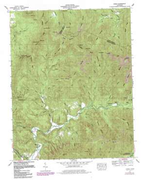
Gobey Topo Map Tennessee
To zoom in, hover over the map of Gobey
USGS Topo Quad 36084b5 - 1:24,000 scale
| Topo Map Name: | Gobey |
| USGS Topo Quad ID: | 36084b5 |
| Print Size: | ca. 21 1/4" wide x 27" high |
| Southeast Coordinates: | 36.125° N latitude / 84.5° W longitude |
| Map Center Coordinates: | 36.1875° N latitude / 84.5625° W longitude |
| U.S. State: | TN |
| Filename: | o36084b5.jpg |
| Download Map JPG Image: | Gobey topo map 1:24,000 scale |
| Map Type: | Topographic |
| Topo Series: | 7.5´ |
| Map Scale: | 1:24,000 |
| Source of Map Images: | United States Geological Survey (USGS) |
| Alternate Map Versions: |
Gobey TN 1935 Download PDF Buy paper map Gobey TN 1946, updated 1946 Download PDF Buy paper map Gobey TN 1952, updated 1954 Download PDF Buy paper map Gobey TN 1952, updated 1971 Download PDF Buy paper map Gobey TN 1952, updated 1980 Download PDF Buy paper map Gobey TN 2010 Download PDF Buy paper map Gobey TN 2013 Download PDF Buy paper map Gobey TN 2016 Download PDF Buy paper map |
1:24,000 Topo Quads surrounding Gobey
> Back to 36084a1 at 1:100,000 scale
> Back to 36084a1 at 1:250,000 scale
> Back to U.S. Topo Maps home
Gobey topo map: Gazetteer
Gobey: Flats
Service Flat elevation 687m 2253′Gobey: Gaps
Big Lick Gap elevation 513m 1683′Grapevine Gap elevation 720m 2362′
Hamby Gap elevation 676m 2217′
Jeff Gap elevation 612m 2007′
Low Gap elevation 678m 2224′
McCartt Gap elevation 753m 2470′
Polly Gap elevation 728m 2388′
Ross Gap elevation 761m 2496′
Webb Gap elevation 679m 2227′
Whiteoak Gap elevation 608m 1994′
Gobey: Mines
Harriman Red Ash Mine elevation 817m 2680′Wilson Pewee Mine elevation 842m 2762′
Gobey: Populated Places
Elizabeth elevation 359m 1177′Emory (historical) elevation 351m 1151′
Gobey elevation 327m 1072′
Melrose (historical) elevation 327m 1072′
Oak Hill elevation 361m 1184′
Gobey: Ridges
Bear Bench Ridge elevation 679m 2227′Gosnell Ridge elevation 691m 2267′
Hangover Ridge elevation 501m 1643′
Huckleberry Ridge elevation 640m 2099′
Gobey: Streams
Beech Branch elevation 307m 1007′Cane Branch elevation 338m 1108′
Dry Branch elevation 371m 1217′
Dry Branch elevation 312m 1023′
Edmund Branch elevation 352m 1154′
Gladey Branch elevation 394m 1292′
Gosnell Branch elevation 419m 1374′
Greasy Creek elevation 317m 1040′
Grimes Branch elevation 391m 1282′
Hall Branch elevation 318m 1043′
Jim Branch elevation 335m 1099′
Joe Creek elevation 389m 1276′
Judge Branch elevation 414m 1358′
Laurel Branch elevation 342m 1122′
Laurel Fork elevation 349m 1145′
Little Creek elevation 330m 1082′
Maden Branch elevation 321m 1053′
Middle Branch elevation 377m 1236′
Mill Branch elevation 326m 1069′
North Prong Flat Fork elevation 414m 1358′
Phillips Creek elevation 371m 1217′
Rhoda Creek elevation 407m 1335′
Rock Creek elevation 311m 1020′
Sang Branch elevation 332m 1089′
Spruce Lick Creek elevation 414m 1358′
Stillhouse Branch elevation 316m 1036′
Tom Branch elevation 338m 1108′
Whiteoak Creek elevation 330m 1082′
Young Creek elevation 351m 1151′
Gobey: Summits
England Mountain elevation 921m 3021′Fork Mountain elevation 787m 2582′
Freels Mountain elevation 774m 2539′
Grassy Mountain elevation 715m 2345′
Griffith Mountain elevation 806m 2644′
High Knob elevation 938m 3077′
Justice Mountain elevation 877m 2877′
Knolling Knob elevation 834m 2736′
Landrom Mountain elevation 884m 2900′
Little Pilot Mountain elevation 606m 1988′
Peaky Mountain elevation 780m 2559′
Pleas McCartt Mountain elevation 849m 2785′
Pond Knob elevation 659m 2162′
Potato Knob elevation 601m 1971′
Richland Mountain elevation 714m 2342′
Thompson Mountain elevation 792m 2598′
Wright Mountain elevation 728m 2388′
Young Mountain elevation 872m 2860′
Gobey: Valleys
Fall Hollow elevation 331m 1085′Holloway Hollow elevation 367m 1204′
Mike Hollow elevation 336m 1102′
Rocky Hollow elevation 331m 1085′
Sugarcamp Hollow elevation 454m 1489′
Gobey digital topo map on disk
Buy this Gobey topo map showing relief, roads, GPS coordinates and other geographical features, as a high-resolution digital map file on DVD:


