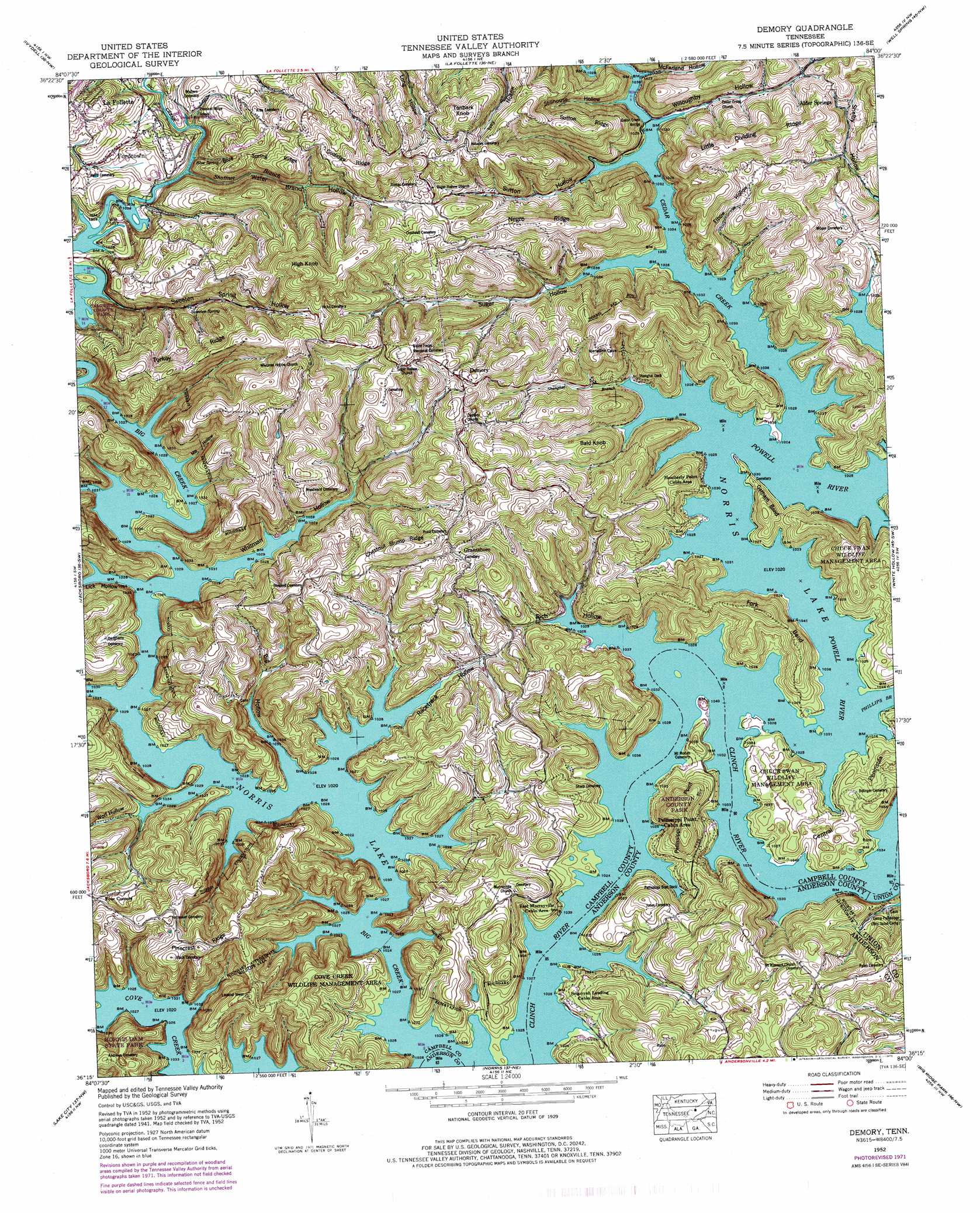
Demory Topo Map Tennessee
To zoom in, hover over the map of Demory
USGS Topo Quad 36084c1 - 1:24,000 scale
| Topo Map Name: | Demory |
| USGS Topo Quad ID: | 36084c1 |
| Print Size: | ca. 21 1/4" wide x 27" high |
| Southeast Coordinates: | 36.25° N latitude / 84° W longitude |
| Map Center Coordinates: | 36.3125° N latitude / 84.0625° W longitude |
| U.S. State: | TN |
| Filename: | o36084c1.jpg |
| Download Map JPG Image: | Demory topo map 1:24,000 scale |
| Map Type: | Topographic |
| Topo Series: | 7.5´ |
| Map Scale: | 1:24,000 |
| Source of Map Images: | United States Geological Survey (USGS) |
| Alternate Map Versions: |
Demory TN 1936 Download PDF Buy paper map Demory TN 1941 Download PDF Buy paper map Demory TN 1941 Download PDF Buy paper map Demory TN 1952 Download PDF Buy paper map Demory TN 1952, updated 1954 Download PDF Buy paper map Demory TN 1952, updated 1975 Download PDF Buy paper map Demory TN 1952, updated 1975 Download PDF Buy paper map Demory TN 2010 Download PDF Buy paper map Demory TN 2013 Download PDF Buy paper map Demory TN 2016 Download PDF Buy paper map |
1:24,000 Topo Quads surrounding Demory
Ketchen |
Jellico West |
Jellico East |
Eagan |
Fork Ridge |
Pioneer |
Ivydell |
La Follette |
Well Spring |
Ausmus |
Block |
Jacksboro |
Demory |
White Hollow |
Maynardville |
Duncan Flats |
Lake City |
Norris |
Big Ridge Park |
Graveston |
Windrock |
Clinton |
Powell |
Fountain City |
John Sevier |
> Back to 36084a1 at 1:100,000 scale
> Back to 36084a1 at 1:250,000 scale
> Back to U.S. Topo Maps home
Demory topo map: Gazetteer
Demory: Bends
Fork Bend elevation 339m 1112′Gatham Bend elevation 367m 1204′
Demory: Bridges
Cedar Creek Bridge elevation 313m 1026′Demory: Capes
Central Peninsula elevation 336m 1102′Pellissippi Point elevation 383m 1256′
Demory: Parks
Anderson County Park elevation 394m 1292′Cove Creek Wildlife Management Area elevation 376m 1233′
Demory: Populated Places
Agee elevation 311m 1020′Agee (historical) elevation 311m 1020′
Alder Springs elevation 385m 1263′
Boy (historical) elevation 311m 1020′
Custer (historical) elevation 430m 1410′
Demory elevation 421m 1381′
Fordtown elevation 342m 1122′
Grantsboro elevation 413m 1354′
Hatmaker (historical) elevation 311m 1020′
Primroy (historical) elevation 313m 1026′
Whitman (historical) elevation 311m 1020′
Demory: Ridges
Blue Spring Ridge elevation 416m 1364′Chestnut Stump Ridge elevation 480m 1574′
Coolidge Ridge elevation 456m 1496′
Little Dividing Ridge elevation 464m 1522′
Negro Ridge elevation 446m 1463′
Pinecrest Ridge elevation 456m 1496′
Sutton Ridge elevation 447m 1466′
Turkey Ridge elevation 433m 1420′
Demory: Springs
Blue Spring elevation 316m 1036′Sweeten Spring elevation 345m 1131′
Demory: Streams
Big Creek elevation 311m 1020′Cedar Creek elevation 311m 1020′
Phillips Branch elevation 311m 1020′
Powell River elevation 311m 1020′
Shanghai Branch elevation 311m 1020′
Shoffner Branch elevation 321m 1053′
Demory: Summits
Bald Knob elevation 403m 1322′High Knob elevation 537m 1761′
Tanbark Knob elevation 489m 1604′
Demory: Valleys
Big Hollow elevation 311m 1020′Elbow Hollow elevation 311m 1020′
Lick Hollow elevation 311m 1020′
McFarland Hollow elevation 311m 1020′
Mill Hollow elevation 311m 1020′
Racetrack Hollow elevation 311m 1020′
Rich Hollow elevation 311m 1020′
Stillhouse Hollow elevation 311m 1020′
Sugar Hollow elevation 311m 1020′
Sutton Hollow elevation 311m 1020′
Sweeten Spring Hollow elevation 311m 1020′
Water Branch Hollow elevation 316m 1036′
Whitman Hollow elevation 311m 1020′
Willoughby Hollow elevation 311m 1020′
Wolf Hollow elevation 311m 1020′
Demory digital topo map on disk
Buy this Demory topo map showing relief, roads, GPS coordinates and other geographical features, as a high-resolution digital map file on DVD: