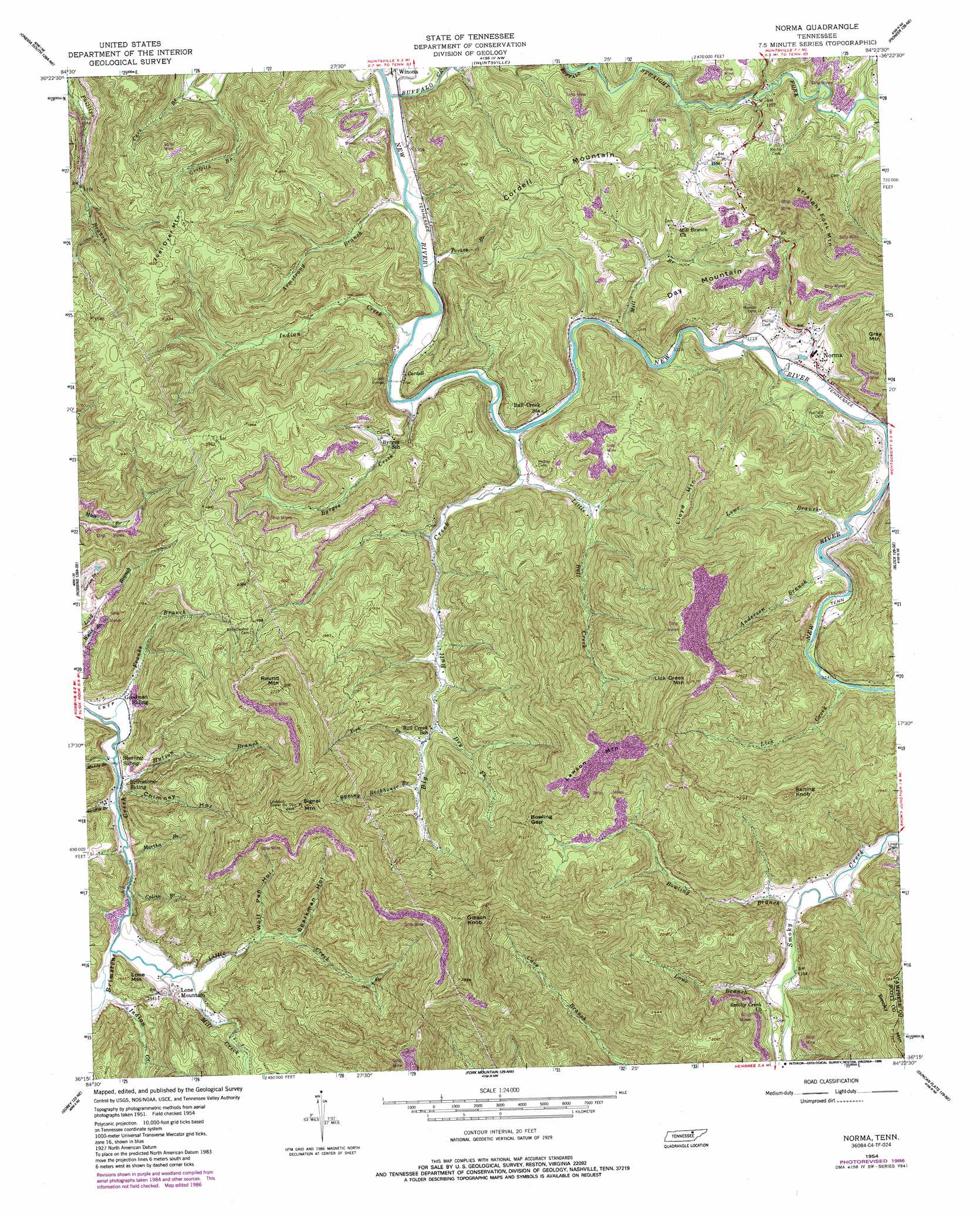
Norma Topo Map Tennessee
To zoom in, hover over the map of Norma
USGS Topo Quad 36084c4 - 1:24,000 scale
| Topo Map Name: | Norma |
| USGS Topo Quad ID: | 36084c4 |
| Print Size: | ca. 21 1/4" wide x 27" high |
| Southeast Coordinates: | 36.25° N latitude / 84.375° W longitude |
| Map Center Coordinates: | 36.3125° N latitude / 84.4375° W longitude |
| U.S. State: | TN |
| Filename: | o36084c4.jpg |
| Download Map JPG Image: | Norma topo map 1:24,000 scale |
| Map Type: | Topographic |
| Topo Series: | 7.5´ |
| Map Scale: | 1:24,000 |
| Source of Map Images: | United States Geological Survey (USGS) |
| Alternate Map Versions: |
Norma TN 1954, updated 1955 Download PDF Buy paper map Norma TN 1954, updated 1970 Download PDF Buy paper map Norma TN 1954, updated 1979 Download PDF Buy paper map Norma TN 1954, updated 1986 Download PDF Buy paper map Norma TN 2010 Download PDF Buy paper map Norma TN 2013 Download PDF Buy paper map Norma TN 2016 Download PDF Buy paper map |
1:24,000 Topo Quads surrounding Norma
Barthell Sw |
Oneida North |
Winfield |
Ketchen |
Jellico West |
Honey Creek |
Oneida South |
Huntsville |
Pioneer |
Ivydell |
Rugby |
Robbins |
Norma |
Block |
Jacksboro |
Pilot Mountain |
Gobey |
Fork Mountain |
Duncan Flats |
Lake City |
Lancing |
Camp Austin |
Petros |
Windrock |
Clinton |
> Back to 36084a1 at 1:100,000 scale
> Back to 36084a1 at 1:250,000 scale
> Back to U.S. Topo Maps home
Norma topo map: Gazetteer
Norma: Bridges
Cordell Bridge elevation 353m 1158′Norma: Gaps
Bowling Gap elevation 645m 2116′Norma: Mines
Allen Mine elevation 545m 1788′Brimestone Mine elevation 409m 1341′
Bryd Mine elevation 681m 2234′
Claiborne-Cotton Mine elevation 433m 1420′
Frank Coker Mine elevation 390m 1279′
Kline Mine elevation 413m 1354′
Lassie Mine elevation 379m 1243′
Martin Mine elevation 597m 1958′
New River Mine elevation 400m 1312′
Pemberton Mine elevation 397m 1302′
Red Jacket Mine elevation 429m 1407′
Robbins Mine elevation 376m 1233′
Schaefer-Goodman Mine elevation 420m 1377′
Stanley Walker Mine elevation 707m 2319′
Straight Fork Mine elevation 618m 2027′
Todd Mine elevation 697m 2286′
Walker Mine elevation 671m 2201′
West Brothers Mine elevation 376m 1233′
Norma: Populated Places
Cordell elevation 364m 1194′Jeffers elevation 391m 1282′
Lone Mountain elevation 407m 1335′
Norma elevation 386m 1266′
Norma: Post Offices
Norma Post Office elevation 392m 1286′Norma: Streams
Anderson Branch elevation 367m 1204′Armstrong Branch elevation 355m 1164′
Big Bull Creek elevation 358m 1174′
Bowling Branch elevation 378m 1240′
Buffalo Creek elevation 346m 1135′
Byrges Creek elevation 353m 1158′
Calvin Branch elevation 371m 1217′
Dry Fork elevation 424m 1391′
Franks Branch elevation 366m 1200′
Griffith Branch elevation 353m 1158′
Griffith Branch elevation 371m 1217′
Hutson Branch elevation 369m 1210′
Indian Creek elevation 353m 1158′
Indian Creek elevation 375m 1230′
Lick Creek elevation 371m 1217′
Little Bull Creek elevation 364m 1194′
Little Creek elevation 376m 1233′
Lowe Branch elevation 365m 1197′
Lowe Branch elevation 381m 1250′
Martha Branch elevation 371m 1217′
Mill Branch elevation 358m 1174′
Mill Creek elevation 378m 1240′
Muddy Branch elevation 370m 1213′
Old House Branch elevation 375m 1230′
Spring Rockhouse Branch elevation 443m 1453′
Straight Fork elevation 364m 1194′
Turkey Branch elevation 354m 1161′
York Branch elevation 432m 1417′
Norma: Summits
Cordell Mountain elevation 535m 1755′Day Mountain elevation 501m 1643′
Gibson Knob elevation 887m 2910′
Joel Dyer Mountain elevation 586m 1922′
Lawson Mountain elevation 792m 2598′
Lick Creek Mountain elevation 801m 2627′
Lloyd Mountain elevation 702m 2303′
Lone Mountain elevation 454m 1489′
Round Mountain elevation 832m 2729′
Salting Knob elevation 736m 2414′
Signal Mountain elevation 887m 2910′
Straight Mountain elevation 687m 2253′
Norma: Valleys
Chimney Hollow elevation 370m 1213′Griffith Hollow elevation 362m 1187′
Sparkman Hollow elevation 412m 1351′
Split Chestnut Hollow elevation 402m 1318′
Wolf Pen Hollow elevation 405m 1328′
Norma digital topo map on disk
Buy this Norma topo map showing relief, roads, GPS coordinates and other geographical features, as a high-resolution digital map file on DVD: