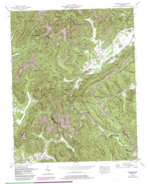
Pioneer Topo Map Tennessee
To zoom in, hover over the map of Pioneer
USGS Topo Quad 36084d3 - 1:24,000 scale
| Topo Map Name: | Pioneer |
| USGS Topo Quad ID: | 36084d3 |
| Print Size: | ca. 21 1/4" wide x 27" high |
| Southeast Coordinates: | 36.375° N latitude / 84.25° W longitude |
| Map Center Coordinates: | 36.4375° N latitude / 84.3125° W longitude |
| U.S. State: | TN |
| Filename: | o36084d3.jpg |
| Download Map JPG Image: | Pioneer topo map 1:24,000 scale |
| Map Type: | Topographic |
| Topo Series: | 7.5´ |
| Map Scale: | 1:24,000 |
| Source of Map Images: | United States Geological Survey (USGS) |
| Alternate Map Versions: |
Pioneer TN 1936 Download PDF Buy paper map Pioneer TN 1946, updated 1947 Download PDF Buy paper map Pioneer TN 1952, updated 1954 Download PDF Buy paper map Pioneer TN 1952, updated 1972 Download PDF Buy paper map Pioneer TN 1952, updated 1980 Download PDF Buy paper map Pioneer TN 1952, updated 1980 Download PDF Buy paper map Pioneer TN 2010 Download PDF Buy paper map Pioneer TN 2013 Download PDF Buy paper map Pioneer TN 2016 Download PDF Buy paper map |
1:24,000 Topo Quads surrounding Pioneer
> Back to 36084a1 at 1:100,000 scale
> Back to 36084a1 at 1:250,000 scale
> Back to U.S. Topo Maps home
Pioneer topo map: Gazetteer
Pioneer: Crossings
Interchange 144 elevation 555m 1820′Pioneer: Gaps
Blockade Gap elevation 376m 1233′Botts Gap elevation 643m 2109′
Braden Gap elevation 645m 2116′
Elk Gap elevation 511m 1676′
Finn Gap elevation 700m 2296′
Marcum Gap elevation 627m 2057′
Poteet Gap elevation 536m 1758′
Sand Gap elevation 435m 1427′
Sexton Gap elevation 408m 1338′
Sharp Gap elevation 438m 1437′
Wesley Gap elevation 698m 2290′
Pioneer: Mines
Mooney Mine elevation 474m 1555′Phillips Red Ash Mine elevation 746m 2447′
Pioneer: Parks
Royal Blue Wildlife Management Area elevation 652m 2139′Pioneer: Populated Places
Buckeye elevation 446m 1463′Pioneer elevation 470m 1541′
Royal Blue elevation 445m 1459′
Stanfill elevation 357m 1171′
Straight Fork elevation 443m 1453′
Terry Creek elevation 372m 1220′
Titus elevation 430m 1410′
Pioneer: Ridges
Chestnut Ridge elevation 565m 1853′Limestone Ridge elevation 705m 2312′
The Lone elevation 423m 1387′
Wash Ridge elevation 543m 1781′
Pioneer: Streams
Bear Branch elevation 487m 1597′Big Branch elevation 424m 1391′
Collins Branch elevation 438m 1437′
Coontail Branch elevation 346m 1135′
Crabtree Branch elevation 433m 1420′
Cross Branch elevation 438m 1437′
Dan Branch elevation 362m 1187′
Douglas Branch elevation 347m 1138′
Drew Branch elevation 402m 1318′
Granny Barnes Branch elevation 378m 1240′
Graves Branch elevation 458m 1502′
Hudson Branch elevation 370m 1213′
Jake Branch elevation 438m 1437′
Johnson Branch elevation 424m 1391′
Lick Branch elevation 459m 1505′
Lick Fork elevation 345m 1131′
Lost Branch elevation 444m 1456′
Mill Branch elevation 438m 1437′
Neal Branch elevation 433m 1420′
Ned Branch elevation 359m 1177′
Rector Branch elevation 451m 1479′
Scruggs Branch elevation 407m 1335′
Shelton Branch elevation 453m 1486′
Simpson Branch elevation 458m 1502′
Smith Cove elevation 476m 1561′
Stell Branch elevation 430m 1410′
Still Creek elevation 433m 1420′
Swamp Branch elevation 440m 1443′
Terry Branch elevation 441m 1446′
Terry Creek elevation 359m 1177′
Titus Creek elevation 426m 1397′
Webb Branch elevation 419m 1374′
Wilson Branch elevation 419m 1374′
Wolf Branch elevation 345m 1131′
Wolfpen Branch elevation 447m 1466′
Pioneer: Summits
Braden Mountain elevation 805m 2641′Buffalo Mountain elevation 780m 2559′
Gobbler Knob elevation 551m 1807′
Gunsight Mountain elevation 739m 2424′
Hackle Knob elevation 612m 2007′
Little Fork Mountain elevation 683m 2240′
Ned Mountain elevation 756m 2480′
Poor Mountain elevation 701m 2299′
Potato Knob elevation 602m 1975′
Sexton Mountain elevation 761m 2496′
Turley Mountain elevation 702m 2303′
View Tree Knob elevation 832m 2729′
Zeb Mountain elevation 690m 2263′
Pioneer: Valleys
Allen Hollow elevation 421m 1381′Botts Hollow elevation 414m 1358′
Frogpond Hollow elevation 381m 1250′
Long Hollow elevation 444m 1456′
Stillhouse Hollow elevation 401m 1315′
Ward Hollow elevation 444m 1456′
Pioneer digital topo map on disk
Buy this Pioneer topo map showing relief, roads, GPS coordinates and other geographical features, as a high-resolution digital map file on DVD:


