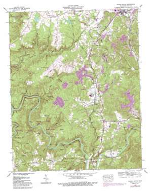
Oneida South Topo Map Tennessee
To zoom in, hover over the map of Oneida South
USGS Topo Quad 36084d5 - 1:24,000 scale
| Topo Map Name: | Oneida South |
| USGS Topo Quad ID: | 36084d5 |
| Print Size: | ca. 21 1/4" wide x 27" high |
| Southeast Coordinates: | 36.375° N latitude / 84.5° W longitude |
| Map Center Coordinates: | 36.4375° N latitude / 84.5625° W longitude |
| U.S. State: | TN |
| Filename: | o36084d5.jpg |
| Download Map JPG Image: | Oneida South topo map 1:24,000 scale |
| Map Type: | Topographic |
| Topo Series: | 7.5´ |
| Map Scale: | 1:24,000 |
| Source of Map Images: | United States Geological Survey (USGS) |
| Alternate Map Versions: |
Helenwood TN 1952, updated 1953 Download PDF Buy paper map Oneida South TN 1952, updated 1969 Download PDF Buy paper map Oneida South TN 1952, updated 1975 Download PDF Buy paper map Oneida South TN 1952, updated 1991 Download PDF Buy paper map Oneida South TN 2010 Download PDF Buy paper map Oneida South TN 2013 Download PDF Buy paper map Oneida South TN 2016 Download PDF Buy paper map |
1:24,000 Topo Quads surrounding Oneida South
> Back to 36084a1 at 1:100,000 scale
> Back to 36084a1 at 1:250,000 scale
> Back to U.S. Topo Maps home
Oneida South topo map: Gazetteer
Oneida South: Airports
Scott Municipal Airport elevation 464m 1522′Oneida South: Bends
Negro Bend elevation 432m 1417′Reed Bottom elevation 337m 1105′
Oneida South: Cliffs
McCoy Rocks elevation 362m 1187′Oneida South: Crossings
Silcott Ford elevation 333m 1092′Oneida South: Dams
Carter Dam elevation 448m 1469′Lays Dam elevation 464m 1522′
Newport Dam elevation 453m 1486′
Pine Creek Number One Dam elevation 438m 1437′
Ponderosa Lake Dam elevation 446m 1463′
W H Swain Dam elevation 420m 1377′
Oneida South: Gaps
Low Gap elevation 401m 1315′Oneida South: Lakes
Cooper Pond elevation 452m 1482′Cooper Pond elevation 451m 1479′
Oneida South: Populated Places
Black Creek elevation 380m 1246′Black Oak elevation 482m 1581′
Helenwood elevation 423m 1387′
High Point elevation 463m 1519′
Mountain View elevation 454m 1489′
New Haven elevation 478m 1568′
New River elevation 364m 1194′
Oneida elevation 440m 1443′
Three Forks elevation 414m 1358′
Toomy elevation 385m 1263′
Verdun elevation 437m 1433′
Oneida South: Post Offices
Helenwood Post Office elevation 427m 1400′New River Post Office elevation 365m 1197′
Oneida South: Reservoirs
Carter Lake elevation 448m 1469′Lays Lake elevation 464m 1522′
Newport Lake elevation 453m 1486′
Pine Creek Number One Lake elevation 438m 1437′
Ponderosa Lake elevation 446m 1463′
W H Swain Lake elevation 420m 1377′
Oneida South: Ridges
Bendix Spur elevation 434m 1423′Big Ridge elevation 464m 1522′
Fork Ridge elevation 481m 1578′
Oneida South: Streams
Ails Branch elevation 378m 1240′Buttram Branch elevation 333m 1092′
Cherry Fork Creek elevation 421m 1381′
Clear Fork elevation 309m 1013′
Greasy Creek elevation 324m 1062′
Laurel Branch elevation 415m 1361′
Lick Branch elevation 334m 1095′
Long Branch elevation 343m 1125′
Low Gap Branch elevation 324m 1062′
Meadow Branch elevation 428m 1404′
Mill Branch elevation 334m 1095′
Mill Branch elevation 377m 1236′
Nance Branch elevation 377m 1236′
New River elevation 309m 1013′
Niggs Creek elevation 428m 1404′
North Fork Pine Creek elevation 430m 1410′
Panther Branch elevation 369m 1210′
Phillips Creek elevation 335m 1099′
Sulphur Creek elevation 414m 1358′
Thomas Branch elevation 412m 1351′
West Branch Phillips Creek elevation 408m 1338′
Oneida South: Summits
Grassy Knob elevation 468m 1535′Graveyard Hill elevation 395m 1295′
Oneida South: Valleys
Cecil Hollow elevation 389m 1276′Chambers Hollow elevation 431m 1414′
Dark Hollow elevation 328m 1076′
Dripping Springs Hollow elevation 340m 1115′
Ellis Hollow elevation 314m 1030′
Phillips Hollow elevation 446m 1463′
Spring Branch Hollow elevation 383m 1256′
Sugarcamp Hollow elevation 412m 1351′
Sugarcamp Hollow elevation 383m 1256′
Tunnel Hollow elevation 352m 1154′
Wolf Fork Hollow elevation 383m 1256′
Oneida South digital topo map on disk
Buy this Oneida South topo map showing relief, roads, GPS coordinates and other geographical features, as a high-resolution digital map file on DVD:


