Winfield Topo Map Tennessee
To zoom in, hover over the map of Winfield
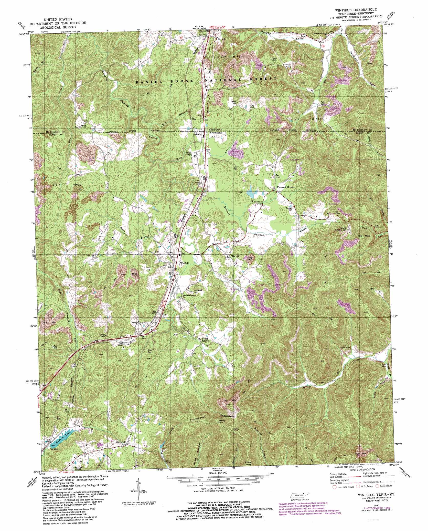
USGS Topo Quad 36084e4 - 1:24,000 scale
| Topo Map Name: | Winfield |
| USGS Topo Quad ID: | 36084e4 |
| Print Size: | ca. 21 1/4" wide x 27" high |
| Southeast Coordinates: | 36.5° N latitude / 84.375° W longitude |
| Map Center Coordinates: | 36.5625° N latitude / 84.4375° W longitude |
| U.S. States: | TN, KY |
| Filename: | o36084e4.jpg |
| Download Map JPG Image: | Winfield topo map 1:24,000 scale |
| Map Type: | Topographic |
| Topo Series: | 7.5´ |
| Map Scale: | 1:24,000 |
| Source of Map Images: | United States Geological Survey (USGS) |
| Alternate Map Versions: |
Winfield TN 1953, updated 1954 Download PDF Buy paper map Winfield TN 1953, updated 1968 Download PDF Buy paper map Winfield TN 1980, updated 1980 Download PDF Buy paper map Winfield TN 1980, updated 1983 Download PDF Buy paper map Winfield TN 2010 Download PDF Buy paper map Winfield TN 2013 Download PDF Buy paper map Winfield TN 2016 Download PDF Buy paper map |
| FStopo: | US Forest Service topo Winfield is available: Download FStopo PDF Download FStopo TIF |
1:24,000 Topo Quads surrounding Winfield
Coopersville |
Nevelsville |
Wiborg |
Cumberland Falls |
Wofford |
Bell Farm |
Barthell |
Whitley City |
Hollyhill |
Williamsburg |
Barthell Sw |
Oneida North |
Winfield |
Ketchen |
Jellico West |
Honey Creek |
Oneida South |
Huntsville |
Pioneer |
Ivydell |
Rugby |
Robbins |
Norma |
Block |
Jacksboro |
> Back to 36084e1 at 1:100,000 scale
> Back to 36084a1 at 1:250,000 scale
> Back to U.S. Topo Maps home
Winfield topo map: Gazetteer
Winfield: Dams
Laxton Lake Dam elevation 445m 1459′Ronald King Dam elevation 402m 1318′
Winfield: Populated Places
Clay Hill elevation 426m 1397′Isham elevation 413m 1354′
Pine Hill elevation 492m 1614′
Piney Grove elevation 411m 1348′
Pleasant Grove elevation 408m 1338′
State Line elevation 404m 1325′
Strunk elevation 435m 1427′
Winfield elevation 404m 1325′
Winfield: Reservoirs
Laxion Lake elevation 445m 1459′Laxton Lake elevation 445m 1459′
Ronald King Lake elevation 402m 1318′
Winfield: Streams
Fox Branch elevation 349m 1145′Isham Creek elevation 373m 1223′
Jones Branch elevation 378m 1240′
Long Fork elevation 342m 1122′
Murphy Creek elevation 329m 1079′
Short Fork elevation 344m 1128′
Trammel Fork elevation 327m 1072′
Walkers Creek elevation 399m 1309′
Winfield: Summits
Honeycutt Mountain elevation 658m 2158′Privet Mountain elevation 641m 2103′
Winfield digital topo map on disk
Buy this Winfield topo map showing relief, roads, GPS coordinates and other geographical features, as a high-resolution digital map file on DVD: