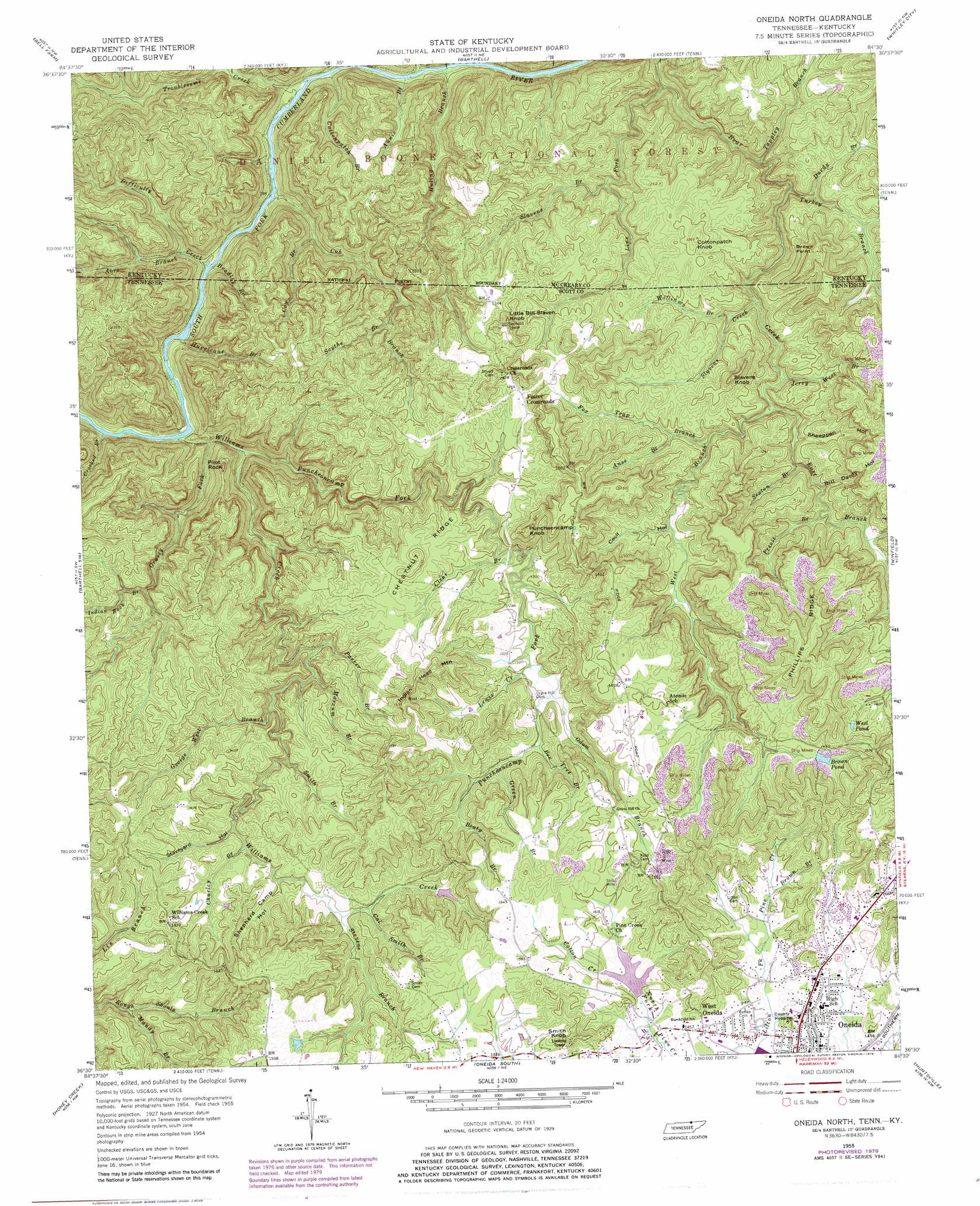
Oneida North Topo Map Tennessee
To zoom in, hover over the map of Oneida North
USGS Topo Quad 36084e5 - 1:24,000 scale
| Topo Map Name: | Oneida North |
| USGS Topo Quad ID: | 36084e5 |
| Print Size: | ca. 21 1/4" wide x 27" high |
| Southeast Coordinates: | 36.5° N latitude / 84.5° W longitude |
| Map Center Coordinates: | 36.5625° N latitude / 84.5625° W longitude |
| U.S. States: | TN, KY |
| Filename: | o36084e5.jpg |
| Download Map JPG Image: | Oneida North topo map 1:24,000 scale |
| Map Type: | Topographic |
| Topo Series: | 7.5´ |
| Map Scale: | 1:24,000 |
| Source of Map Images: | United States Geological Survey (USGS) |
| Alternate Map Versions: |
Oneida North TN 1955, updated 1956 Download PDF Buy paper map Oneida North TN 1955, updated 1968 Download PDF Buy paper map Oneida North TN 1955, updated 1979 Download PDF Buy paper map Oneida North TN 1955, updated 1979 Download PDF Buy paper map Oneida North TN 2011 Download PDF Buy paper map Oneida North TN 2013 Download PDF Buy paper map Oneida North TN 2016 Download PDF Buy paper map |
| FStopo: | US Forest Service topo Oneida North is available: Download FStopo PDF Download FStopo TIF |
1:24,000 Topo Quads surrounding Oneida North
Monticello |
Coopersville |
Nevelsville |
Wiborg |
Cumberland Falls |
Parmleysville |
Bell Farm |
Barthell |
Whitley City |
Hollyhill |
Sharp Place |
Barthell Sw |
Oneida North |
Winfield |
Ketchen |
Stockton |
Honey Creek |
Oneida South |
Huntsville |
Pioneer |
Burrville |
Rugby |
Robbins |
Norma |
Block |
> Back to 36084e1 at 1:100,000 scale
> Back to 36084a1 at 1:250,000 scale
> Back to U.S. Topo Maps home
Oneida North topo map: Gazetteer
Oneida North: Dams
Conservation League Dam elevation 415m 1361′Pine Creek Number Four Dam elevation 439m 1440′
Oneida North: Lakes
Brown Pond elevation 441m 1446′West Pond elevation 443m 1453′
Oneida North: Parks
Big South Fork National River and Recreation Area elevation 339m 1112′Oneida North: Pillars
Pilot Rock elevation 380m 1246′Oneida North: Populated Places
Foster Crossroads elevation 405m 1328′Roberta elevation 456m 1496′
West Oneida elevation 443m 1453′
Oneida North: Reservoirs
Conservation League Lake elevation 415m 1361′Howard H Baker Senior Lake elevation 439m 1440′
Oneida North: Ridges
Chestnut Ridge elevation 434m 1423′Phillips Ridge elevation 502m 1646′
Oneida North: Streams
Abre Branch elevation 250m 820′Annie Branch elevation 246m 807′
Anse Branch elevation 361m 1184′
Beaty Branch elevation 395m 1295′
Bee Tree Branch elevation 393m 1289′
Bradley Branch elevation 251m 823′
Brown Branch elevation 445m 1459′
Cal Smith Branch elevation 395m 1295′
Charley Branch elevation 387m 1269′
Clear Branch elevation 378m 1240′
Cotton Creek elevation 439m 1440′
Cottonpatch Branch elevation 246m 807′
Cow Branch elevation 273m 895′
Crooked Branch elevation 250m 820′
Cub Branch elevation 243m 797′
Dardy Branch elevation 319m 1046′
Difficulty Creek elevation 243m 797′
East Branch Bear Creek elevation 322m 1056′
Fox Trap Branch elevation 335m 1099′
George West Branch elevation 364m 1194′
Grassy Fork elevation 251m 823′
Green Branch elevation 394m 1292′
Huling Branch elevation 240m 787′
Hurricane Branch elevation 244m 800′
Indian Rock Branch elevation 344m 1128′
Jerry West Branch elevation 322m 1056′
Lewis Creek elevation 388m 1272′
Line Fork elevation 279m 915′
Line Fork elevation 242m 793′
Litton Fork elevation 433m 1420′
Lone Cliff Branch elevation 267m 875′
Mandy Branch elevation 366m 1200′
Marcum Branch elevation 356m 1167′
Odum Branch elevation 389m 1276′
Oil Well Branch elevation 240m 787′
Parker Branch elevation 355m 1164′
Pine Creek elevation 430m 1410′
Pine Creek elevation 439m 1440′
Previt Branch elevation 342m 1122′
Puncheoncamp Fork elevation 253m 830′
Scythe Branch elevation 346m 1135′
Sexton Branch elevation 341m 1118′
Slavens Branch elevation 337m 1105′
Slavens Creek elevation 312m 1023′
Smith Branch elevation 378m 1240′
Stevens Branch elevation 394m 1292′
Tappley Branch elevation 304m 997′
Troublesome Creek elevation 244m 800′
Turkey Branch elevation 295m 967′
Watson Branch elevation 268m 879′
West Branch Bear Creek elevation 322m 1056′
Williams Branch elevation 332m 1089′
Williams Creek elevation 253m 830′
Oneida North: Summits
Brown Point elevation 449m 1473′Cottonpatch Knob elevation 409m 1341′
Indian Head Mountain elevation 484m 1587′
Little Bill Slaven Knob elevation 440m 1443′
Puncheoncamp Knob elevation 470m 1541′
Slavens Knob elevation 425m 1394′
Smith Knob elevation 502m 1646′
Oneida North: Valleys
Bill Dardy Hollow elevation 343m 1125′Cecil Hollow elevation 349m 1145′
Sheeppen Hollow elevation 334m 1095′
Shepherd Camp Hollow elevation 393m 1289′
Staveyard Hollow elevation 393m 1289′
Oneida North digital topo map on disk
Buy this Oneida North topo map showing relief, roads, GPS coordinates and other geographical features, as a high-resolution digital map file on DVD: