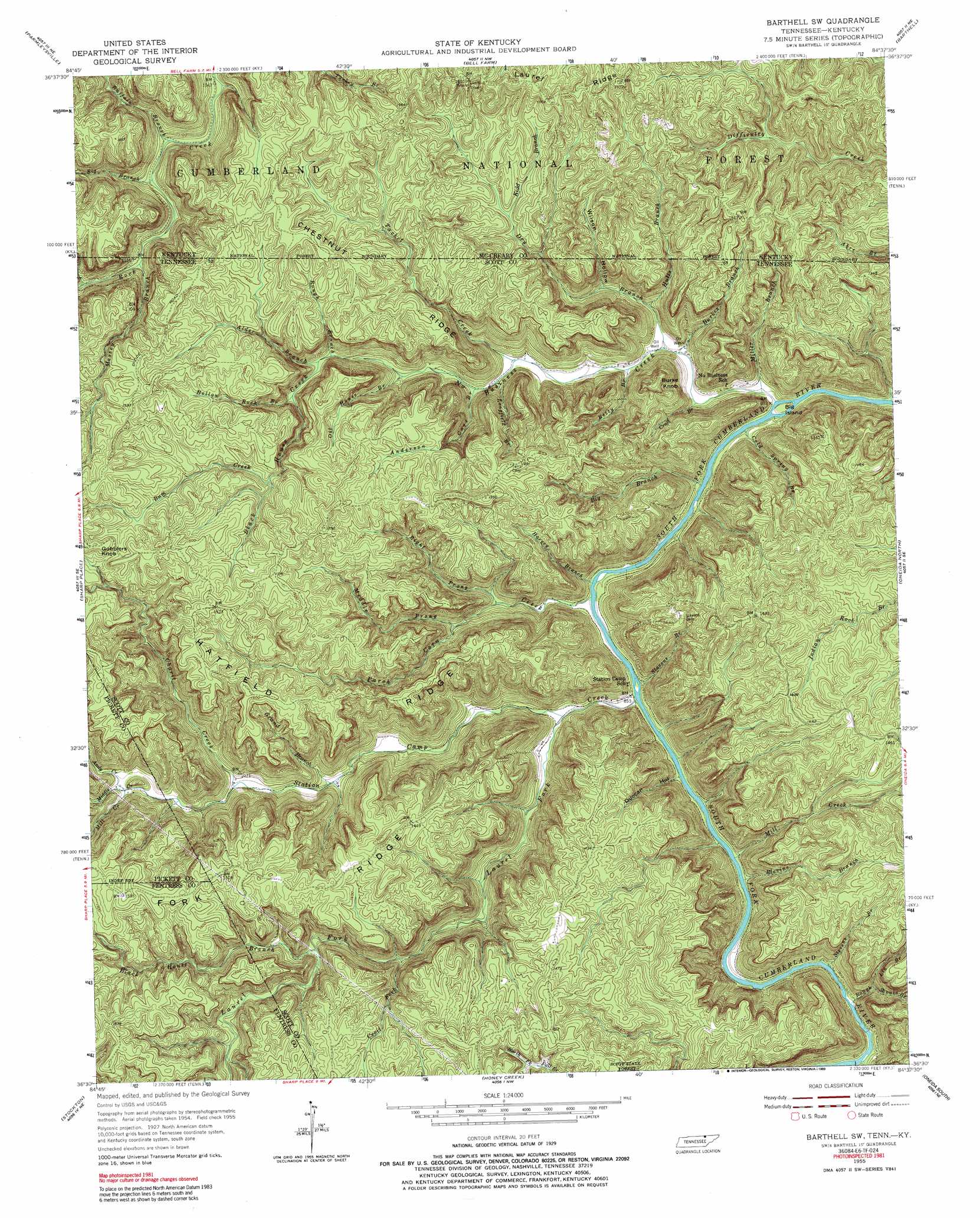
Barthell Sw Topo Map Tennessee
To zoom in, hover over the map of Barthell Sw
USGS Topo Quad 36084e6 - 1:24,000 scale
| Topo Map Name: | Barthell Sw |
| USGS Topo Quad ID: | 36084e6 |
| Print Size: | ca. 21 1/4" wide x 27" high |
| Southeast Coordinates: | 36.5° N latitude / 84.625° W longitude |
| Map Center Coordinates: | 36.5625° N latitude / 84.6875° W longitude |
| U.S. States: | TN, KY |
| Filename: | o36084e6.jpg |
| Download Map JPG Image: | Barthell Sw topo map 1:24,000 scale |
| Map Type: | Topographic |
| Topo Series: | 7.5´ |
| Map Scale: | 1:24,000 |
| Source of Map Images: | United States Geological Survey (USGS) |
| Alternate Map Versions: |
Barthell SW TN 1955, updated 1956 Download PDF Buy paper map Barthell SW TN 1955, updated 1967 Download PDF Buy paper map Barthell SW TN 1955, updated 1967 Download PDF Buy paper map Barthell SW TN 1955, updated 1989 Download PDF Buy paper map Barthell SW TN 2000, updated 2001 Download PDF Buy paper map Barthell SW TN 2010 Download PDF Buy paper map Barthell SW TN 2013 Download PDF Buy paper map Barthell SW TN 2016 Download PDF Buy paper map |
| FStopo: | US Forest Service topo Barthell SW is available: Download FStopo PDF Download FStopo TIF |
1:24,000 Topo Quads surrounding Barthell Sw
Parnell |
Monticello |
Coopersville |
Nevelsville |
Wiborg |
Powersburg |
Parmleysville |
Bell Farm |
Barthell |
Whitley City |
Pall Mall |
Sharp Place |
Barthell Sw |
Oneida North |
Winfield |
Jamestown |
Stockton |
Honey Creek |
Oneida South |
Huntsville |
Grimsley |
Burrville |
Rugby |
Robbins |
Norma |
> Back to 36084e1 at 1:100,000 scale
> Back to 36084a1 at 1:250,000 scale
> Back to U.S. Topo Maps home
Barthell Sw topo map: Gazetteer
Barthell Sw: Arches
Twin Arches elevation 418m 1371′Barthell Sw: Islands
Big Island elevation 252m 826′Barthell Sw: Populated Places
Elva (historical) elevation 255m 836′Barthell Sw: Ridges
Chestnut Ridge elevation 424m 1391′Fork Ridge elevation 442m 1450′
Hatfield Ridge elevation 437m 1433′
Barthell Sw: Streams
Alder Branch elevation 321m 1053′Anderson Cave Branch elevation 279m 915′
Andy Creek elevation 318m 1043′
Betty Branch elevation 259m 849′
Big Branch elevation 325m 1066′
Big Branch elevation 247m 810′
Bill Branch elevation 261m 856′
Black House Branch elevation 357m 1171′
Black House Creek elevation 319m 1046′
Blevins Branch elevation 256m 839′
Buffalo Branch elevation 328m 1076′
Bum Creek elevation 400m 1312′
Burkes Branch elevation 256m 839′
Cecil Fork elevation 323m 1059′
Charit Creek elevation 298m 977′
Cold Spring Branch elevation 248m 813′
Craft Branch elevation 253m 830′
Dry Branch elevation 260m 853′
Grand Branch elevation 284m 931′
Harvey Branch elevation 251m 823′
Hollow Rock Branch elevation 329m 1079′
Hutts Branch elevation 267m 875′
Hutts Branch elevation 265m 869′
Kidd Branch elevation 392m 1286′
Laurel Fork elevation 258m 846′
Lin Branch elevation 284m 931′
Longfield Branch elevation 284m 931′
Massey Branch elevation 335m 1099′
Middle Creek elevation 307m 1007′
Middle Prong Parch Corn Creek elevation 315m 1033′
Mill Creek elevation 316m 1036′
Mill Creek elevation 255m 836′
Miller Branch elevation 248m 813′
No Business Creek elevation 247m 810′
Oil House Branch elevation 285m 935′
Parch Corn Creek elevation 251m 823′
Right Prong Parch Corn Creek elevation 284m 931′
Rough Branch elevation 313m 1026′
Rough Shoals Branch elevation 256m 839′
Slavens Branch elevation 256m 839′
Station Camp Creek elevation 252m 826′
Stevens Branch elevation 256m 839′
Tacket Creek elevation 270m 885′
Barthell Sw: Summits
Burke Knob elevation 419m 1374′Gobblers Knob elevation 474m 1555′
Barthell Sw: Valleys
Duncan Hollow elevation 253m 830′Wilson Hollow elevation 286m 938′
Barthell Sw digital topo map on disk
Buy this Barthell Sw topo map showing relief, roads, GPS coordinates and other geographical features, as a high-resolution digital map file on DVD: