Pall Mall Topo Map Tennessee
To zoom in, hover over the map of Pall Mall
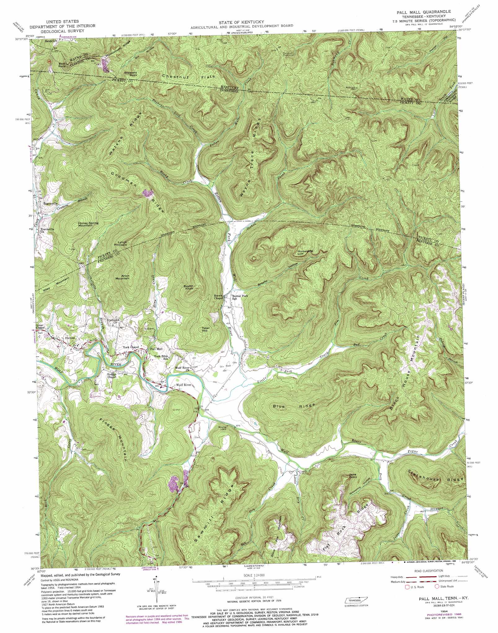
USGS Topo Quad 36084e8 - 1:24,000 scale
| Topo Map Name: | Pall Mall |
| USGS Topo Quad ID: | 36084e8 |
| Print Size: | ca. 21 1/4" wide x 27" high |
| Southeast Coordinates: | 36.5° N latitude / 84.875° W longitude |
| Map Center Coordinates: | 36.5625° N latitude / 84.9375° W longitude |
| U.S. States: | TN, KY |
| Filename: | o36084e8.jpg |
| Download Map JPG Image: | Pall Mall topo map 1:24,000 scale |
| Map Type: | Topographic |
| Topo Series: | 7.5´ |
| Map Scale: | 1:24,000 |
| Source of Map Images: | United States Geological Survey (USGS) |
| Alternate Map Versions: |
Pall Mall TN 1954, updated 1956 Download PDF Buy paper map Pall Mall TN 1954, updated 1970 Download PDF Buy paper map Pall Mall TN 1954, updated 1979 Download PDF Buy paper map Pall Mall TN 1954, updated 1986 Download PDF Buy paper map Pall Mall TN 2011 Download PDF Buy paper map Pall Mall TN 2013 Download PDF Buy paper map Pall Mall TN 2016 Download PDF Buy paper map |
| FStopo: | US Forest Service topo Pall Mall is available: Download FStopo PDF Download FStopo TIF |
1:24,000 Topo Quads surrounding Pall Mall
Wolf Creek Dam |
Cumberland City |
Parnell |
Monticello |
Coopersville |
Albany |
Savage |
Powersburg |
Parmleysville |
Bell Farm |
Byrdstown |
Moodyville |
Pall Mall |
Sharp Place |
Barthell Sw |
Alpine |
Riverton |
Jamestown |
Stockton |
Honey Creek |
Crawford |
Wilder |
Grimsley |
Burrville |
Rugby |
> Back to 36084e1 at 1:100,000 scale
> Back to 36084a1 at 1:250,000 scale
> Back to U.S. Topo Maps home
Pall Mall topo map: Gazetteer
Pall Mall: Cliffs
Horseshoe Cliff elevation 474m 1555′Horseshoe Cliff elevation 487m 1597′
Jane Point elevation 469m 1538′
Pall Mall: Flats
Chestnut Flats elevation 527m 1729′Pall Mall: Mines
Leffew Mine elevation 422m 1384′Leffew Mine elevation 268m 879′
Pall Mall: Parks
Sergeant Alvin York Mill State Historic Area elevation 270m 885′Pall Mall: Pillars
Lynch Pinnacle elevation 519m 1702′Pall Mall: Populated Places
Forbus elevation 269m 882′Pall Mall elevation 267m 875′
Sandclift elevation 404m 1325′
Travisville elevation 281m 921′
Wolf River elevation 269m 882′
Pall Mall: Post Offices
Pall Mall Post Office elevation 273m 895′Sandclift Post Office (historical) elevation 398m 1305′
Pall Mall: Ridges
Blue Ridge elevation 411m 1348′Flat Rock Ridge elevation 506m 1660′
Flat Rock Ridge elevation 498m 1633′
Goodman Ridge elevation 493m 1617′
Goodman Ridge elevation 511m 1676′
Huckleberry Ridge elevation 473m 1551′
Sawmill Ridge elevation 495m 1624′
Sawmill Ridge elevation 508m 1666′
Statehouse Ridge elevation 493m 1617′
Watson Ridge elevation 508m 1666′
Watson Ridge elevation 502m 1646′
Wayne Trace Ridge elevation 539m 1768′
Wayne Trace Ridge elevation 532m 1745′
Pall Mall: Streams
Big Dry Creek elevation 269m 882′Brooks Creek elevation 279m 915′
Buckey Lick Creek elevation 323m 1059′
Buckeye Lick Creek elevation 319m 1046′
Bud Creek elevation 278m 912′
Bud Creek elevation 276m 905′
Crabtree Branch elevation 285m 935′
Crabtree Branch elevation 273m 895′
Delk Creek elevation 277m 908′
Dry Hollow Creek elevation 401m 1315′
Fallen Water Creek elevation 319m 1046′
Fallen Water Creek elevation 298m 977′
Jesse Creek elevation 291m 954′
Jim Creek elevation 276m 905′
Little Dry Creek elevation 276m 905′
Little Dry Creek elevation 270m 885′
Little Jack Creek elevation 267m 875′
Little Jack Creek elevation 265m 869′
Pogue Creek elevation 277m 908′
Reed Creek elevation 256m 839′
Rocky Creek elevation 297m 974′
Rocky Creek elevation 297m 974′
Rotten Fork Wolf River elevation 265m 869′
Rotten Fork Wolf River elevation 268m 879′
Shellotte Branch elevation 266m 872′
Shellotte Branch elevation 258m 846′
Short Horn Creek elevation 261m 856′
Short Horn Creek elevation 264m 866′
Stewart Creek elevation 291m 954′
Stokes Creek elevation 283m 928′
Williams Creek elevation 289m 948′
Pall Mall: Summits
Arion Mountain elevation 469m 1538′Arion Mountain elevation 462m 1515′
Bald Rock elevation 527m 1729′
Baylor Knob elevation 459m 1505′
Baylor Knob elevation 469m 1538′
Black House Mountain elevation 513m 1683′
Black House Mountain elevation 502m 1646′
Fentress Hill elevation 496m 1627′
Fitzgerald Knob elevation 499m 1637′
Frogg Mountain elevation 260m 853′
Frogge Mountain elevation 484m 1587′
Honey Spring Mountain elevation 434m 1423′
Jane Point elevation 495m 1624′
Lynch Pinnacle elevation 519m 1702′
Slippery Rock elevation 525m 1722′
Steve Pile Mountain elevation 465m 1525′
Steve Pile Mountain elevation 508m 1666′
Tater Hill elevation 409m 1341′
Tater Hill elevation 402m 1318′
Pall Mall: Valleys
Brooks Hollow elevation 278m 912′Brooks Hollow elevation 276m 905′
Grapevine Hollow elevation 283m 928′
Grapevine Hollow elevation 282m 925′
Spruce Pin Hollow elevation 407m 1335′
Pall Mall digital topo map on disk
Buy this Pall Mall topo map showing relief, roads, GPS coordinates and other geographical features, as a high-resolution digital map file on DVD: