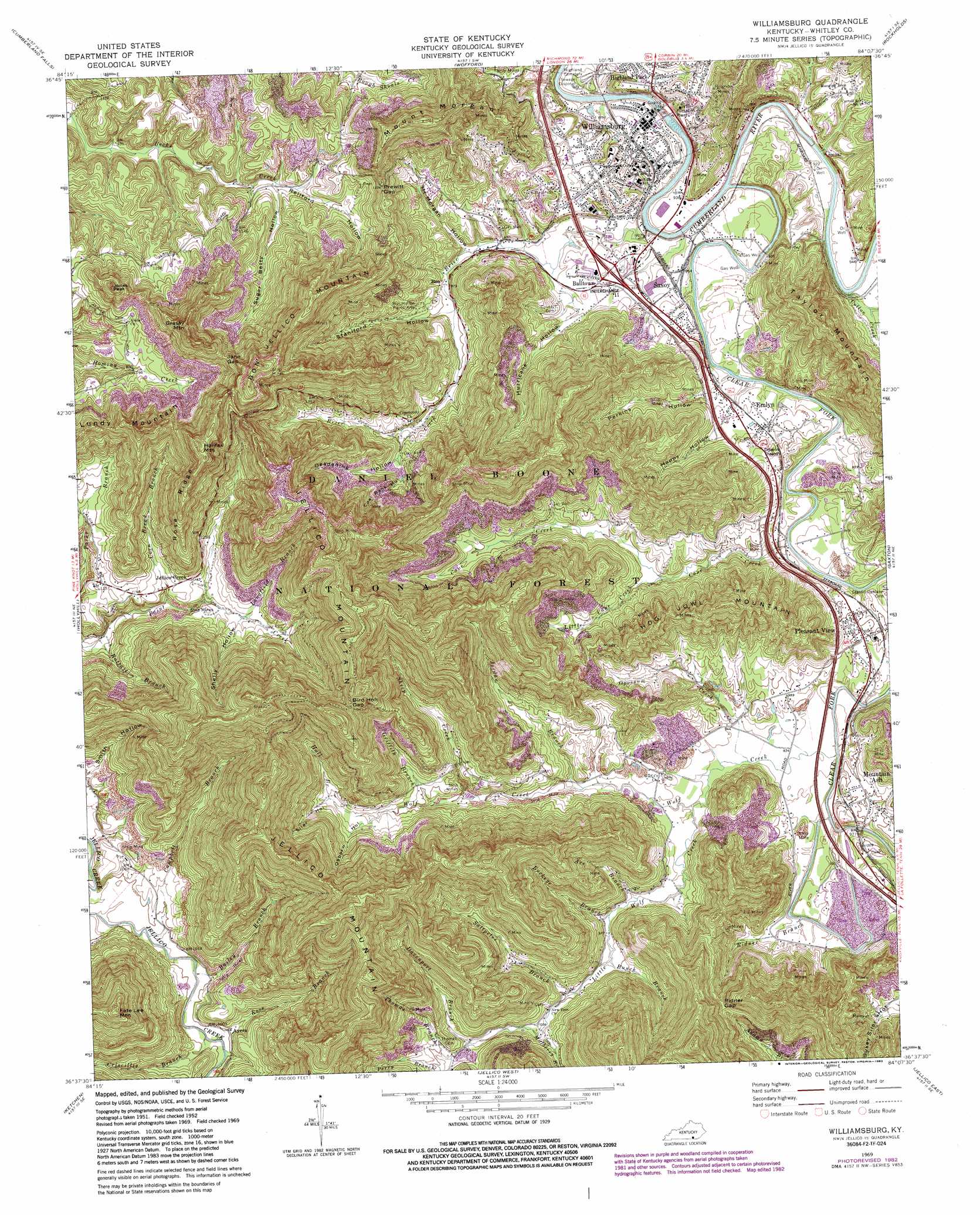
Williamsburg Topo Map Kentucky
To zoom in, hover over the map of Williamsburg
USGS Topo Quad 36084f2 - 1:24,000 scale
| Topo Map Name: | Williamsburg |
| USGS Topo Quad ID: | 36084f2 |
| Print Size: | ca. 21 1/4" wide x 27" high |
| Southeast Coordinates: | 36.625° N latitude / 84.125° W longitude |
| Map Center Coordinates: | 36.6875° N latitude / 84.1875° W longitude |
| U.S. State: | KY |
| Filename: | o36084f2.jpg |
| Download Map JPG Image: | Williamsburg topo map 1:24,000 scale |
| Map Type: | Topographic |
| Topo Series: | 7.5´ |
| Map Scale: | 1:24,000 |
| Source of Map Images: | United States Geological Survey (USGS) |
| Alternate Map Versions: |
Williamsburg KY 1952, updated 1954 Download PDF Buy paper map Williamsburg KY 1969, updated 1972 Download PDF Buy paper map Williamsburg KY 1969, updated 1983 Download PDF Buy paper map Williamsburg KY 2010 Download PDF Buy paper map Williamsburg KY 2013 Download PDF Buy paper map Williamsburg KY 2016 Download PDF Buy paper map |
| FStopo: | US Forest Service topo Williamsburg is available: Download FStopo PDF Download FStopo TIF |
1:24,000 Topo Quads surrounding Williamsburg
Hail |
Sawyer |
Vox |
Corbin |
Heidrick |
Wiborg |
Cumberland Falls |
Wofford |
Rockholds |
Barbourville |
Whitley City |
Hollyhill |
Williamsburg |
Saxton |
Frakes |
Winfield |
Ketchen |
Jellico West |
Jellico East |
Eagan |
Huntsville |
Pioneer |
Ivydell |
La Follette |
Well Spring |
> Back to 36084e1 at 1:100,000 scale
> Back to 36084a1 at 1:250,000 scale
> Back to U.S. Topo Maps home
Williamsburg topo map: Gazetteer
Williamsburg: Gaps
Bird Holt Gap elevation 543m 1781′Jane Gap elevation 485m 1591′
Prewitt Gap elevation 427m 1400′
Ridner Gap elevation 423m 1387′
Williamsburg: Populated Places
Ayers elevation 306m 1003′Balltown elevation 293m 961′
Bon elevation 297m 974′
Emlyn elevation 296m 971′
Highland Park elevation 322m 1056′
Jellico Creek elevation 365m 1197′
Mountain Ash elevation 304m 997′
Pleasant View elevation 304m 997′
Savoy elevation 290m 951′
Williamsburg elevation 283m 928′
Williamsburg: Ridges
Rose Ridge elevation 548m 1797′Williamsburg: Streams
Ace Branch elevation 296m 971′Bailey Branch elevation 299m 980′
Brier Creek elevation 271m 889′
Buckeye Branch elevation 295m 967′
Bunch Branch elevation 298m 977′
Campbell Branch elevation 299m 980′
Cane Creek elevation 280m 918′
Clear Fork elevation 271m 889′
Corn Bread Branch elevation 317m 1040′
Cotton Creek elevation 279m 915′
Criscillis Branch elevation 299m 980′
Davenport Branch elevation 322m 1056′
Griffith Branch elevation 318m 1043′
Hall Branch elevation 339m 1112′
Jordan Branch elevation 295m 967′
Little Cane Creek elevation 298m 977′
Little Wolf Creek elevation 286m 938′
Longfield Branch elevation 346m 1135′
Mulberry Branch elevation 310m 1017′
Opossum Creek elevation 283m 928′
Rattail Branch elevation 297m 974′
Ridner Branch elevation 283m 928′
Ross Branch elevation 299m 980′
Saltpeter Branch elevation 304m 997′
Sheep Creek elevation 313m 1026′
Thomas Branch elevation 325m 1066′
Wolf Creek elevation 279m 915′
Williamsburg: Summits
Bon Jellico Mountain elevation 597m 1958′Fate Lee Mountain elevation 623m 2043′
Grassy Mountain elevation 569m 1866′
Halifax Mountain elevation 587m 1925′
Hog Jowl Mountain elevation 441m 1446′
Jellico Mountain elevation 648m 2125′
Jones Peak elevation 508m 1666′
Lundy Mountain elevation 556m 1824′
Mount Morgan elevation 540m 1771′
Williamsburg: Valleys
Coal Bank Hollow elevation 342m 1122′Deadening Hollow elevation 332m 1089′
Happy Hollow elevation 293m 961′
Hurricane Hollow elevation 292m 958′
Mount Morgan Hollow elevation 297m 974′
Osborn Hollow elevation 345m 1131′
Perkins Hollow elevation 287m 941′
Rellford Hollow elevation 330m 1082′
Shelly Hollow elevation 347m 1138′
Siler Hollow elevation 350m 1148′
Smith Hollow elevation 313m 1026′
Staniford Hollow elevation 304m 997′
Sugar Betty Hollow elevation 316m 1036′
Williamsburg digital topo map on disk
Buy this Williamsburg topo map showing relief, roads, GPS coordinates and other geographical features, as a high-resolution digital map file on DVD: