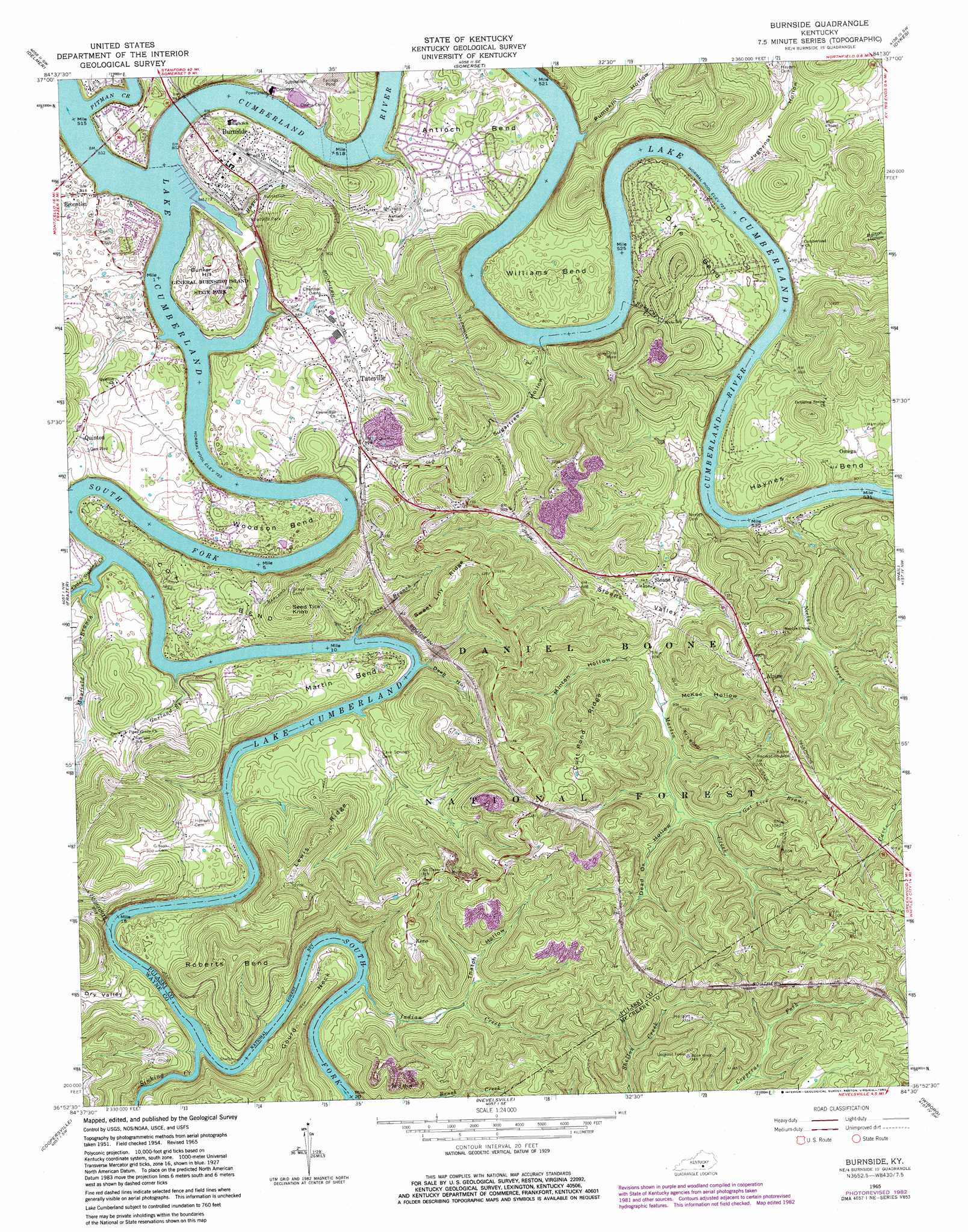
Burnside Topo Map Kentucky
To zoom in, hover over the map of Burnside
USGS Topo Quad 36084h5 - 1:24,000 scale
| Topo Map Name: | Burnside |
| USGS Topo Quad ID: | 36084h5 |
| Print Size: | ca. 21 1/4" wide x 27" high |
| Southeast Coordinates: | 36.875° N latitude / 84.5° W longitude |
| Map Center Coordinates: | 36.9375° N latitude / 84.5625° W longitude |
| U.S. State: | KY |
| Filename: | o36084h5.jpg |
| Download Map JPG Image: | Burnside topo map 1:24,000 scale |
| Map Type: | Topographic |
| Topo Series: | 7.5´ |
| Map Scale: | 1:24,000 |
| Source of Map Images: | United States Geological Survey (USGS) |
| Alternate Map Versions: |
Burnside KY 1954, updated 1955 Download PDF Buy paper map Burnside KY 1954, updated 1965 Download PDF Buy paper map Burnside KY 1965, updated 1967 Download PDF Buy paper map Burnside KY 1965, updated 1976 Download PDF Buy paper map Burnside KY 1965, updated 1983 Download PDF Buy paper map Burnside KY 2010 Download PDF Buy paper map Burnside KY 2013 Download PDF Buy paper map Burnside KY 2016 Download PDF Buy paper map |
| FStopo: | US Forest Service topo Burnside is available: Download FStopo PDF Download FStopo TIF |
1:24,000 Topo Quads surrounding Burnside
Mintonville |
Science Hill |
Bobtown |
Shopville |
Billows |
Faubush |
Delmer |
Somerset |
Dykes |
Ano |
Mill Springs |
Frazer |
Burnside |
Hail |
Sawyer |
Monticello |
Coopersville |
Nevelsville |
Wiborg |
Cumberland Falls |
Parmleysville |
Bell Farm |
Barthell |
Whitley City |
Hollyhill |
> Back to 36084e1 at 1:100,000 scale
> Back to 36084a1 at 1:250,000 scale
> Back to U.S. Topo Maps home
Burnside topo map: Gazetteer
Burnside: Basins
Sloans Valley elevation 243m 797′Burnside: Bends
Antioch Bend elevation 272m 892′Cox Bend elevation 281m 921′
Dixie Bend elevation 263m 862′
Haynes Bend elevation 272m 892′
Martin Bend elevation 257m 843′
Roberts Bend elevation 295m 967′
Williams Bend elevation 269m 882′
Woodson Bend elevation 262m 859′
Burnside: Capes
Gourd Neck elevation 278m 912′Burnside: Parks
Alpine Recreation Area elevation 348m 1141′General Burnside Island State Park elevation 254m 833′
Burnside: Populated Places
Alpine elevation 347m 1138′Bronston elevation 251m 823′
Burnside elevation 262m 859′
Keno elevation 361m 1184′
Omega elevation 258m 846′
Sloans Valley elevation 256m 839′
Tateville elevation 262m 859′
Burnside: Post Offices
Keith Post Office (historical) elevation 235m 770′Burnside: Ridges
Curt Pond Ridge elevation 334m 1095′Lewis Ridge elevation 376m 1233′
Sweet Lily Ridge elevation 380m 1246′
Burnside: Streams
Baker Spring Creek elevation 226m 741′Big South Fork Cumberland River elevation 220m 721′
Cain Branch elevation 220m 721′
Cedar Sinking Creek elevation 220m 721′
Garland Branch elevation 226m 741′
Gut Lick Branch elevation 264m 866′
Hayes Branch elevation 220m 721′
Indian Creek elevation 227m 744′
Martin Creek elevation 240m 787′
Mayfield Branch elevation 220m 721′
Neelys Creek elevation 255m 836′
Pitman Creek elevation 220m 721′
Sinking Creek elevation 220m 721′
Burnside: Summits
Bunker Hill elevation 272m 892′Seed Tick Knob elevation 366m 1200′
Burnside: Valleys
Dead Ox Hollow elevation 260m 853′Deep Hollow elevation 220m 721′
Dry Valley elevation 225m 738′
Jugornot Hollow elevation 251m 823′
McKee Hollow elevation 243m 797′
Minton Hollow elevation 244m 800′
Pumpkin Hollow elevation 251m 823′
Sugartree Hollow elevation 239m 784′
Thatch Hollow elevation 250m 820′
Burnside digital topo map on disk
Buy this Burnside topo map showing relief, roads, GPS coordinates and other geographical features, as a high-resolution digital map file on DVD: