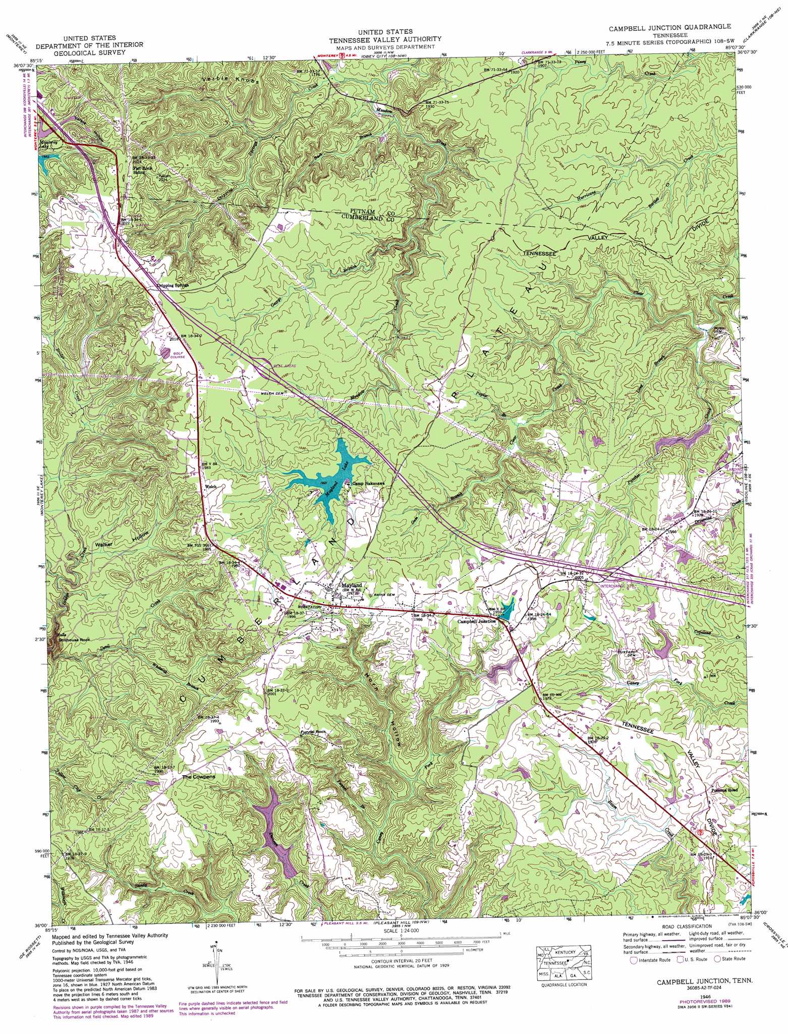
Campbell Junction Topo Map Tennessee
To zoom in, hover over the map of Campbell Junction
USGS Topo Quad 36085a2 - 1:24,000 scale
| Topo Map Name: | Campbell Junction |
| USGS Topo Quad ID: | 36085a2 |
| Print Size: | ca. 21 1/4" wide x 27" high |
| Southeast Coordinates: | 36° N latitude / 85.125° W longitude |
| Map Center Coordinates: | 36.0625° N latitude / 85.1875° W longitude |
| U.S. State: | TN |
| Filename: | o36085a2.jpg |
| Download Map JPG Image: | Campbell Junction topo map 1:24,000 scale |
| Map Type: | Topographic |
| Topo Series: | 7.5´ |
| Map Scale: | 1:24,000 |
| Source of Map Images: | United States Geological Survey (USGS) |
| Alternate Map Versions: |
Campbell Junction TN 1935 Download PDF Buy paper map Campbell Junction TN 1946, updated 1974 Download PDF Buy paper map Campbell Junction TN 1946, updated 1976 Download PDF Buy paper map Campbell Junction TN 1946, updated 1989 Download PDF Buy paper map Campbell Junction TN 1950 Download PDF Buy paper map Campbell Junction TN 2010 Download PDF Buy paper map Campbell Junction TN 2013 Download PDF Buy paper map Campbell Junction TN 2016 Download PDF Buy paper map |
1:24,000 Topo Quads surrounding Campbell Junction
Windle |
Okalona |
Crawford |
Wilder |
Grimsley |
Cookeville East |
Monterey |
Obey City |
Clarkrange |
Jones Knob |
Dry Valley |
Monterey Lake |
Campbell Junction |
Isoline |
Fox Creek |
Sparta |
De Rossett |
Pleasant Hill |
Crossville |
Dorton |
Bald Knob |
Lonewood |
Herbert Domain |
Vandever |
Grassy Cove |
> Back to 36085a1 at 1:100,000 scale
> Back to 36084a1 at 1:250,000 scale
> Back to U.S. Topo Maps home
Campbell Junction topo map: Gazetteer
Campbell Junction: Cliffs
Stillhouse Rock elevation 504m 1653′Campbell Junction: Crossings
Interchange 311 elevation 603m 1978′Campbell Junction: Dams
Hood Lake Dam elevation 567m 1860′Mayland Lake Dam elevation 585m 1919′
Campbell Junction: Pillars
Funnel Rock elevation 592m 1942′Campbell Junction: Populated Places
Campbell Junction elevation 598m 1961′Drowning Creek elevation 591m 1938′
Hillwood Estates elevation 602m 1975′
Mayland elevation 601m 1971′
Pomona Road elevation 585m 1919′
Campbell Junction: Reservoirs
Hood Lake elevation 567m 1860′Mayland Lake elevation 585m 1919′
Campbell Junction: Streams
Bartlett Creek elevation 554m 1817′Buck Branch elevation 521m 1709′
Devil Creek elevation 476m 1561′
Dripping Springs Creek elevation 523m 1715′
Funnel Branch elevation 532m 1745′
George Branch elevation 535m 1755′
Gum Branch elevation 563m 1847′
Long Branch elevation 525m 1722′
Panther Creek elevation 527m 1729′
Poplar Branch elevation 557m 1827′
Whiteoak Branch elevation 540m 1771′
Campbell Junction: Summits
Verble Knobs elevation 587m 1925′Campbell Junction: Valleys
Horn Hollow elevation 533m 1748′Verble Hollow elevation 562m 1843′
Walker Hollow elevation 541m 1774′
Campbell Junction digital topo map on disk
Buy this Campbell Junction topo map showing relief, roads, GPS coordinates and other geographical features, as a high-resolution digital map file on DVD: