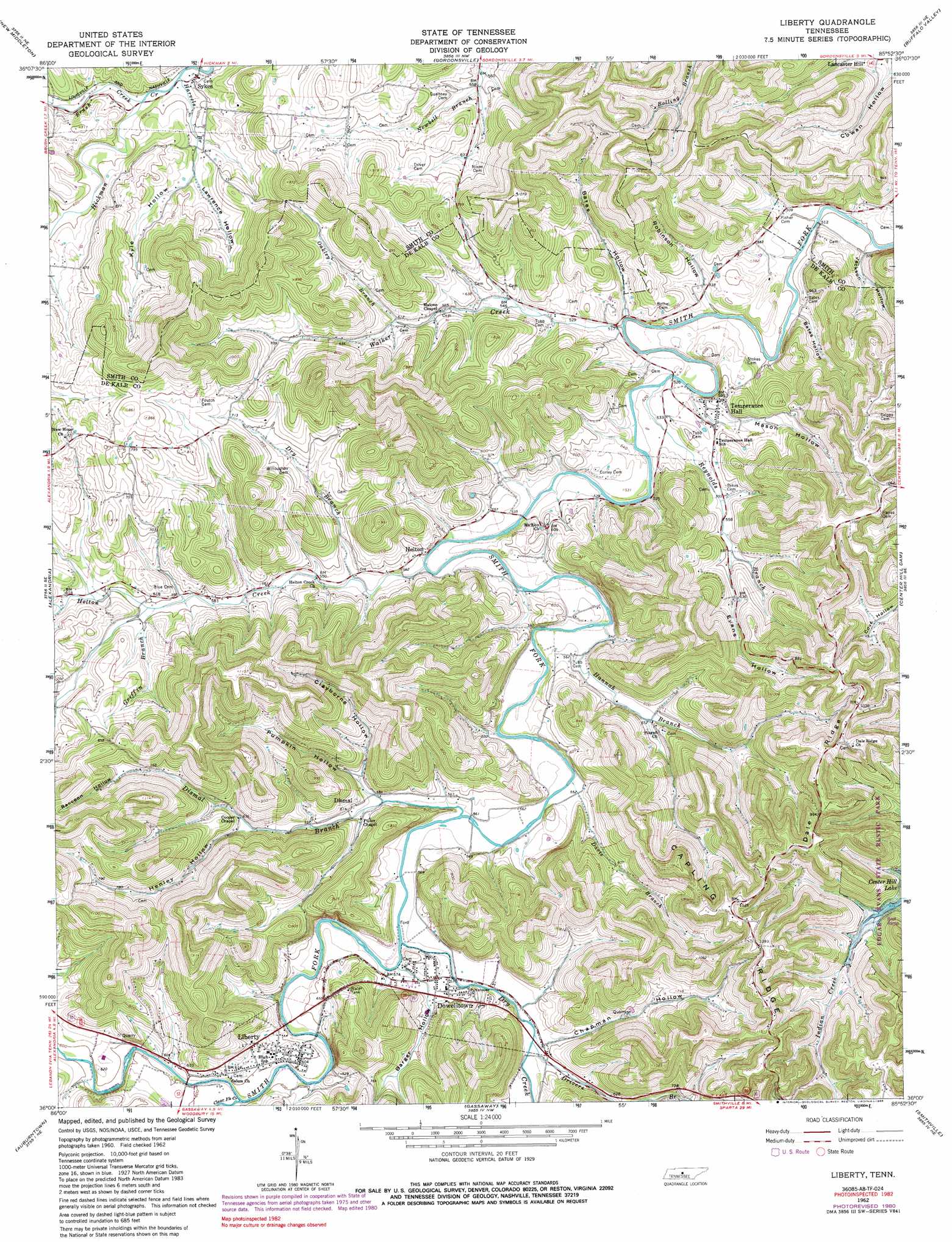
Liberty Topo Map Tennessee
To zoom in, hover over the map of Liberty
USGS Topo Quad 36085a8 - 1:24,000 scale
| Topo Map Name: | Liberty |
| USGS Topo Quad ID: | 36085a8 |
| Print Size: | ca. 21 1/4" wide x 27" high |
| Southeast Coordinates: | 36° N latitude / 85.875° W longitude |
| Map Center Coordinates: | 36.0625° N latitude / 85.9375° W longitude |
| U.S. State: | TN |
| Filename: | o36085a8.jpg |
| Download Map JPG Image: | Liberty topo map 1:24,000 scale |
| Map Type: | Topographic |
| Topo Series: | 7.5´ |
| Map Scale: | 1:24,000 |
| Source of Map Images: | United States Geological Survey (USGS) |
| Alternate Map Versions: |
Liberty TN 1962, updated 1964 Download PDF Buy paper map Liberty TN 1962, updated 1980 Download PDF Buy paper map Liberty TN 1962, updated 1988 Download PDF Buy paper map Liberty TN 2010 Download PDF Buy paper map Liberty TN 2013 Download PDF Buy paper map Liberty TN 2016 Download PDF Buy paper map |
1:24,000 Topo Quads surrounding Liberty
Bellwood |
Dixon Springs |
Carthage |
Granville |
Gainesboro |
Shop Springs |
New Middleton |
Gordonsville |
Buffalo Valley |
Baxter |
Watertown |
Alexandria |
Liberty |
Center Hill Dam |
Silver Point |
Milton |
Auburntown |
Gassaway |
Smithville |
Sligo Bridge |
Readyville |
Woodbury |
Short Mountain |
Dibrell |
Campaign |
> Back to 36085a1 at 1:100,000 scale
> Back to 36084a1 at 1:250,000 scale
> Back to U.S. Topo Maps home
Liberty topo map: Gazetteer
Liberty: Cliffs
Gin Bluff elevation 179m 587′Liberty: Populated Places
Dowelltown elevation 176m 577′Helton elevation 168m 551′
Liberty elevation 186m 610′
Sykes elevation 180m 590′
Temperance Hall elevation 179m 587′
Liberty: Ridges
Capling Ridge elevation 343m 1125′Chapling Ridge elevation 332m 1089′
Dale Ridge elevation 322m 1056′
Liberty: Streams
Brush Creek elevation 173m 567′Clear Fork Creek elevation 177m 580′
Davis Branch elevation 164m 538′
Dismal Branch elevation 169m 554′
Drivers Branch elevation 173m 567′
Dry Branch elevation 164m 538′
Dry Creek elevation 169m 554′
Griffin Branch elevation 180m 590′
Hannah Branch elevation 164m 538′
Harvels Branch elevation 173m 567′
Helton Creek elevation 158m 518′
Oakley Branch elevation 184m 603′
Reynolds Branch elevation 158m 518′
Walker Creek elevation 152m 498′
Liberty: Valleys
Baccoon Hollow elevation 237m 777′Barger Hollow elevation 170m 557′
Bates Hollow elevation 152m 498′
Bates Hollow elevation 153m 501′
Caplinger Hollow elevation 167m 547′
Chapman Hollow elevation 174m 570′
Clayborne Hollow elevation 178m 583′
Evans Hollow elevation 173m 567′
Henley Hollow elevation 188m 616′
Jackson Hollow elevation 152m 498′
Kyle Hollow elevation 192m 629′
Lawrence Hollow elevation 192m 629′
Malone Hollow elevation 180m 590′
Mason Hollow elevation 153m 501′
Myers Hollow elevation 208m 682′
Oakley Hollow elevation 189m 620′
Pumpkin Hollow elevation 169m 554′
Pumpkin Hollow elevation 174m 570′
Robinson Hollow elevation 152m 498′
Scott Hollow elevation 183m 600′
Wilson Hollow elevation 201m 659′
Liberty digital topo map on disk
Buy this Liberty topo map showing relief, roads, GPS coordinates and other geographical features, as a high-resolution digital map file on DVD: