Cookeville East Topo Map Tennessee
To zoom in, hover over the map of Cookeville East
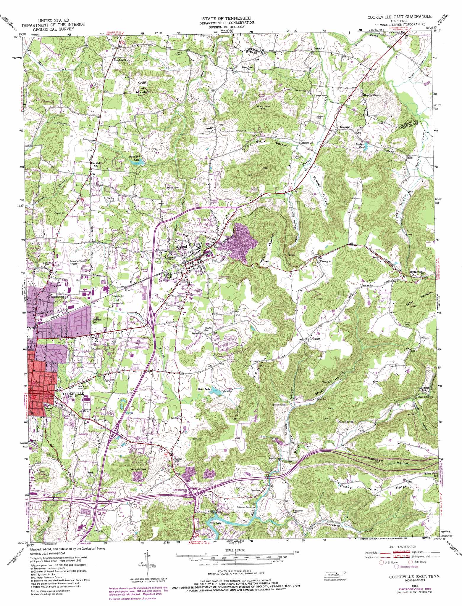
USGS Topo Quad 36085b4 - 1:24,000 scale
| Topo Map Name: | Cookeville East |
| USGS Topo Quad ID: | 36085b4 |
| Print Size: | ca. 21 1/4" wide x 27" high |
| Southeast Coordinates: | 36.125° N latitude / 85.375° W longitude |
| Map Center Coordinates: | 36.1875° N latitude / 85.4375° W longitude |
| U.S. State: | TN |
| Filename: | o36085b4.jpg |
| Download Map JPG Image: | Cookeville East topo map 1:24,000 scale |
| Map Type: | Topographic |
| Topo Series: | 7.5´ |
| Map Scale: | 1:24,000 |
| Source of Map Images: | United States Geological Survey (USGS) |
| Alternate Map Versions: |
Cookeville East TN 1953, updated 1955 Download PDF Buy paper map Cookeville East TN 1953, updated 1968 Download PDF Buy paper map Cookeville East TN 1953, updated 1975 Download PDF Buy paper map Cookeville East TN 1953, updated 1986 Download PDF Buy paper map Cookeville East TN 2010 Download PDF Buy paper map Cookeville East TN 2013 Download PDF Buy paper map Cookeville East TN 2016 Download PDF Buy paper map |
1:24,000 Topo Quads surrounding Cookeville East
Whitleyville |
Burristown |
Hilham |
Livingston |
Alpine |
Gainesboro |
Dodson Branch |
Windle |
Okalona |
Crawford |
Baxter |
Cookeville West |
Cookeville East |
Monterey |
Obey City |
Silver Point |
Burgess Falls |
Dry Valley |
Monterey Lake |
Campbell Junction |
Sligo Bridge |
Cassville |
Sparta |
De Rossett |
Pleasant Hill |
> Back to 36085a1 at 1:100,000 scale
> Back to 36084a1 at 1:250,000 scale
> Back to U.S. Topo Maps home
Cookeville East topo map: Gazetteer
Cookeville East: Airports
Browne Airport elevation 334m 1095′Putnam County Airport (historical) elevation 344m 1128′
Cookeville East: Crossings
Interchange 288 elevation 343m 1125′Interchange 290 elevation 352m 1154′
Cookeville East: Lakes
Buck Lake elevation 327m 1072′Puckett Pond elevation 329m 1079′
Quinland Lake elevation 320m 1049′
Cookeville East: Oilfields
Spring Creek Oil Field elevation 291m 954′Cookeville East: Populated Places
Algood elevation 339m 1112′Bangham elevation 348m 1141′
Beverly Hills elevation 353m 1158′
Bilbrey Park elevation 346m 1135′
Briargate elevation 342m 1122′
Brotherton elevation 435m 1427′
Buck Lake Estates elevation 334m 1095′
Buck Mountain Estates elevation 451m 1479′
Burton Estates elevation 335m 1099′
Candyland Estates elevation 335m 1099′
Capshaw Woods elevation 320m 1049′
Country Club Estates elevation 339m 1112′
Countryside Estates elevation 339m 1112′
Darwin Park elevation 341m 1118′
Deberry Subdivision elevation 349m 1145′
Eastwood elevation 331m 1085′
Garmar Subdivision elevation 346m 1135′
Grandview elevation 348m 1141′
Indian Hills elevation 345m 1131′
Jeremiah elevation 304m 997′
Lake Valley elevation 292m 958′
Laurel Park elevation 340m 1115′
Marchbanks (historical) elevation 311m 1020′
Mountain Meadows elevation 438m 1437′
Netherlands (historical) elevation 293m 961′
Oak Park Estates elevation 322m 1056′
Oaklawn elevation 332m 1089′
Park Village elevation 344m 1128′
Parragon elevation 428m 1404′
Pleasant View elevation 327m 1072′
Poinsettia Subdivision elevation 347m 1138′
Poplar Estates elevation 320m 1049′
Poplar Grove elevation 298m 977′
Post Oak elevation 350m 1148′
Post Oak Estates elevation 343m 1125′
Ridgecrest elevation 344m 1128′
Ridgewood Estates elevation 335m 1099′
Rocky Point elevation 432m 1417′
Selby (historical) elevation 353m 1158′
Shenandoah Estates elevation 348m 1141′
Shennon Village elevation 348m 1141′
Suntree Subdivision elevation 347m 1138′
Terry Subdivision elevation 328m 1076′
The Lowlands elevation 339m 1112′
Village Green elevation 338m 1108′
White Plains elevation 342m 1122′
Winona elevation 352m 1154′
Cookeville East: Post Offices
Algood Post Office elevation 341m 1118′Cookeville East: Reservoirs
Maxwell Lake elevation 311m 1020′Cookeville East: Ridges
Rocky Point Ridge elevation 429m 1407′Cookeville East: Streams
Barnes Hollow Branch elevation 297m 974′Boles Branch elevation 289m 948′
Burtons Branch elevation 346m 1135′
Cleghorn Creek elevation 289m 948′
Hurricane Creek elevation 291m 954′
Short Creek elevation 317m 1040′
Talent Branch elevation 292m 958′
Cookeville East: Summits
Algood Mountain elevation 444m 1456′Buck Mountain elevation 452m 1482′
Buck Mountain elevation 432m 1417′
Green Mountain elevation 379m 1243′
Jones Mountain elevation 524m 1719′
Verble Mountain elevation 367m 1204′
Ward Mountain elevation 350m 1148′
Cookeville East: Valleys
Barnes Hollow elevation 304m 997′Black Bottom elevation 303m 994′
Chimney Springs Hollow elevation 309m 1013′
Cleghorn Hollow elevation 311m 1020′
Hidden Hollow elevation 292m 958′
Madewell Hollow elevation 297m 974′
Pointer Hollow elevation 303m 994′
Rockwell Hollow elevation 291m 954′
Talent Hollow elevation 292m 958′
Welch Hollow elevation 304m 997′
Wiser Hollow elevation 298m 977′
Cookeville East digital topo map on disk
Buy this Cookeville East topo map showing relief, roads, GPS coordinates and other geographical features, as a high-resolution digital map file on DVD: