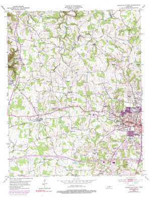
Cookeville West Topo Map Tennessee
To zoom in, hover over the map of Cookeville West
USGS Topo Quad 36085b5 - 1:24,000 scale
| Topo Map Name: | Cookeville West |
| USGS Topo Quad ID: | 36085b5 |
| Print Size: | ca. 21 1/4" wide x 27" high |
| Southeast Coordinates: | 36.125° N latitude / 85.5° W longitude |
| Map Center Coordinates: | 36.1875° N latitude / 85.5625° W longitude |
| U.S. State: | TN |
| Filename: | o36085b5.jpg |
| Download Map JPG Image: | Cookeville West topo map 1:24,000 scale |
| Map Type: | Topographic |
| Topo Series: | 7.5´ |
| Map Scale: | 1:24,000 |
| Source of Map Images: | United States Geological Survey (USGS) |
| Alternate Map Versions: |
Cookeville West TN 1953, updated 1955 Download PDF Buy paper map Cookeville West TN 1953, updated 1969 Download PDF Buy paper map Cookeville West TN 1953, updated 1975 Download PDF Buy paper map Cookeville West TN 1953, updated 1990 Download PDF Buy paper map Cookeville West TN 1953, updated 1990 Download PDF Buy paper map Cookeville West TN 2010 Download PDF Buy paper map Cookeville West TN 2013 Download PDF Buy paper map Cookeville West TN 2016 Download PDF Buy paper map |
1:24,000 Topo Quads surrounding Cookeville West
> Back to 36085a1 at 1:100,000 scale
> Back to 36084a1 at 1:250,000 scale
> Back to U.S. Topo Maps home
Cookeville West topo map: Gazetteer
Cookeville West: Crossings
Interchange 286 elevation 334m 1095′Interchange 287 elevation 335m 1099′
Cookeville West: Dams
Green Valley Farm Lake Dam elevation 304m 997′Cookeville West: Falls
Cummins Falls elevation 234m 767′Cookeville West: Parks
Cane Creek Park elevation 311m 1020′Cookeville West: Populated Places
Apple Valley Estates elevation 331m 1085′Ashcroft Subdivision elevation 329m 1079′
Bill Smith Subdivision elevation 329m 1079′
Blackburn Hills Estates elevation 293m 961′
Bloomington Springs elevation 323m 1059′
Brandywine Estates elevation 320m 1049′
College Heights elevation 338m 1108′
Colonial Acres elevation 319m 1046′
Cookeville elevation 334m 1095′
Deberry Heights elevation 340m 1115′
Double Springs elevation 310m 1017′
Ensor Park elevation 331m 1085′
Forest Hills elevation 329m 1079′
Grandiose Field elevation 310m 1017′
Green Acres elevation 342m 1122′
Green Hills elevation 321m 1053′
Harley Subdivision elevation 321m 1053′
Hillsdale elevation 328m 1076′
Holladay elevation 343m 1125′
Honeybrook elevation 319m 1046′
Long Meadows elevation 311m 1020′
Marie White Subdivision elevation 342m 1122′
McCrary Subdivision elevation 336m 1102′
Melrose elevation 334m 1095′
Mount Vernon elevation 347m 1138′
Oakdale elevation 305m 1000′
Oakland elevation 335m 1099′
Petite Subdivision elevation 327m 1072′
Pippen Springs Estates elevation 311m 1020′
Quality Estates elevation 322m 1056′
Rolling Meadows elevation 329m 1079′
Rose Garden Estates elevation 332m 1089′
Shepherd Hills elevation 333m 1092′
Sherwood Estates elevation 335m 1099′
Shiloh elevation 308m 1010′
Snow Mayberry Subdivision elevation 317m 1040′
Speck Subdivision elevation 330m 1082′
Springdale elevation 339m 1112′
Sun Valley elevation 317m 1040′
Tanglewood elevation 341m 1118′
Tara Estates elevation 309m 1013′
Westgate elevation 323m 1059′
Wildwood elevation 335m 1099′
Cookeville West: Post Offices
Bloomington Springs Post Office elevation 321m 1053′Cookeville Post Office elevation 337m 1105′
Cookeville West: Reservoirs
Cane Creek Lake elevation 309m 1013′Green Valley Farm Lake elevation 304m 997′
Cookeville West: Streams
East Blackburn Fork elevation 261m 856′Kuykendall Branch elevation 304m 997′
Little Creek elevation 273m 895′
Rector Branch elevation 280m 918′
West Blackburn Fork elevation 262m 859′
Cookeville West: Summits
Pilot Knob elevation 408m 1338′Cookeville West digital topo map on disk
Buy this Cookeville West topo map showing relief, roads, GPS coordinates and other geographical features, as a high-resolution digital map file on DVD:


