Livingston Topo Map Tennessee
To zoom in, hover over the map of Livingston
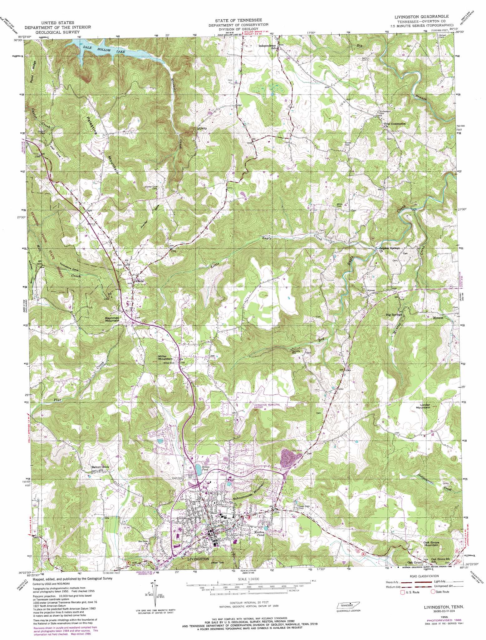
USGS Topo Quad 36085d3 - 1:24,000 scale
| Topo Map Name: | Livingston |
| USGS Topo Quad ID: | 36085d3 |
| Print Size: | ca. 21 1/4" wide x 27" high |
| Southeast Coordinates: | 36.375° N latitude / 85.25° W longitude |
| Map Center Coordinates: | 36.4375° N latitude / 85.3125° W longitude |
| U.S. State: | TN |
| Filename: | o36085d3.jpg |
| Download Map JPG Image: | Livingston topo map 1:24,000 scale |
| Map Type: | Topographic |
| Topo Series: | 7.5´ |
| Map Scale: | 1:24,000 |
| Source of Map Images: | United States Geological Survey (USGS) |
| Alternate Map Versions: |
Livingston TN 1944 Download PDF Buy paper map Livingston TN 1955, updated 1956 Download PDF Buy paper map Livingston TN 1955, updated 1956 Download PDF Buy paper map Livingston TN 1955, updated 1984 Download PDF Buy paper map Livingston TN 1955, updated 1986 Download PDF Buy paper map Livingston TN 1955, updated 1986 Download PDF Buy paper map Livingston TN 2010 Download PDF Buy paper map Livingston TN 2013 Download PDF Buy paper map Livingston TN 2016 Download PDF Buy paper map |
1:24,000 Topo Quads surrounding Livingston
Vernon |
Blacks Ferry |
Frogue |
Albany |
Savage |
Celina |
Dale Hollow Dam |
Dale Hollow Reservoir Se |
Byrdstown |
Moodyville |
Burristown |
Hilham |
Livingston |
Alpine |
Riverton |
Dodson Branch |
Windle |
Okalona |
Crawford |
Wilder |
Cookeville West |
Cookeville East |
Monterey |
Obey City |
Clarkrange |
> Back to 36085a1 at 1:100,000 scale
> Back to 36084a1 at 1:250,000 scale
> Back to U.S. Topo Maps home
Livingston topo map: Gazetteer
Livingston: Airports
Livingston Municipal Airport elevation 322m 1056′Livingston: Lakes
Dillon Pond elevation 308m 1010′Keeton Pond elevation 316m 1036′
Livingston: Populated Places
Allons elevation 434m 1423′Big Springs elevation 276m 905′
Free Communion elevation 303m 994′
Garretts Mill elevation 276m 905′
Howard Chapel elevation 332m 1089′
Independence elevation 318m 1043′
Livingston elevation 313m 1026′
Oak Grove elevation 399m 1309′
Unity elevation 307m 1007′
Ward (historical) elevation 320m 1049′
Livingston: Post Offices
Allons Post Office (historical) elevation 423m 1387′Livingston: Streams
Little Eagle Creek elevation 237m 777′Monroe Creek elevation 225m 738′
Livingston: Summits
Linder Mountain elevation 447m 1466′Miller Mountain elevation 502m 1646′
Oak Grove Mountain elevation 491m 1610′
Palestine Mountain elevation 434m 1423′
Reynolds Mountain elevation 489m 1604′
Schoolhouse Mountain elevation 373m 1223′
Livingston: Valleys
Andrew Cove elevation 276m 905′Hall Cove elevation 331m 1085′
Hunter Cove elevation 298m 977′
Tompkins Cove elevation 276m 905′
Livingston digital topo map on disk
Buy this Livingston topo map showing relief, roads, GPS coordinates and other geographical features, as a high-resolution digital map file on DVD: