Albany Topo Map Kentucky
To zoom in, hover over the map of Albany
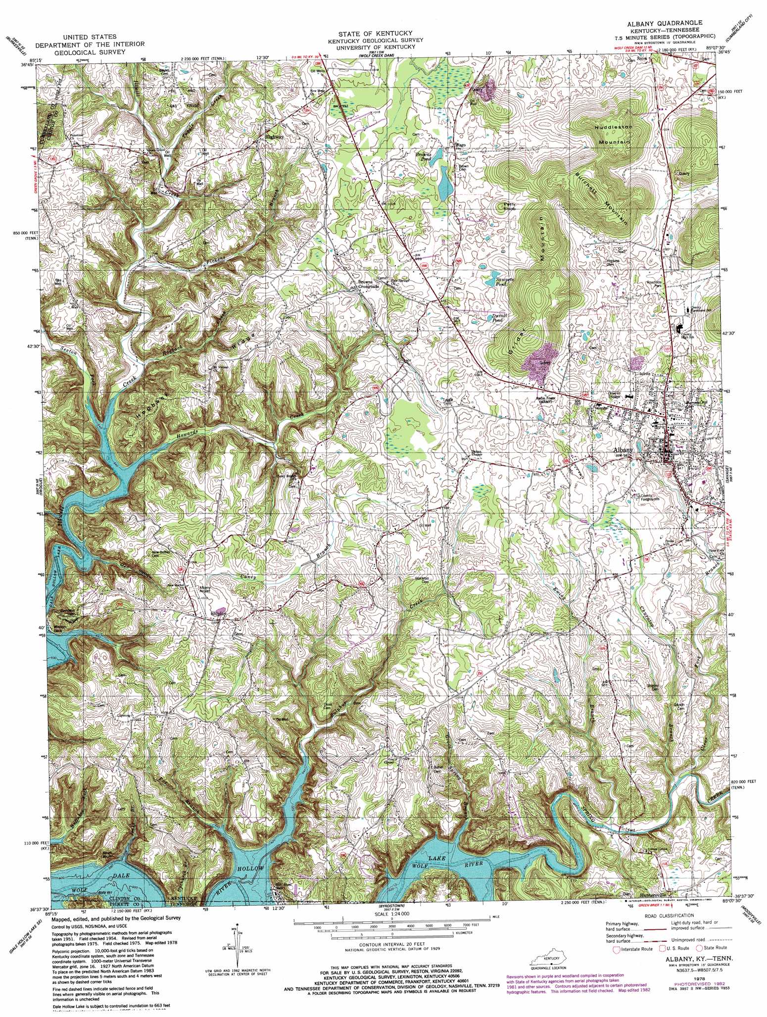
USGS Topo Quad 36085f2 - 1:24,000 scale
| Topo Map Name: | Albany |
| USGS Topo Quad ID: | 36085f2 |
| Print Size: | ca. 21 1/4" wide x 27" high |
| Southeast Coordinates: | 36.625° N latitude / 85.125° W longitude |
| Map Center Coordinates: | 36.6875° N latitude / 85.1875° W longitude |
| U.S. States: | KY, TN |
| Filename: | o36085f2.jpg |
| Download Map JPG Image: | Albany topo map 1:24,000 scale |
| Map Type: | Topographic |
| Topo Series: | 7.5´ |
| Map Scale: | 1:24,000 |
| Source of Map Images: | United States Geological Survey (USGS) |
| Alternate Map Versions: |
Albany KY 1954, updated 1955 Download PDF Buy paper map Albany KY 1954, updated 1967 Download PDF Buy paper map Albany KY 1978, updated 1978 Download PDF Buy paper map Albany KY 1978, updated 1983 Download PDF Buy paper map Albany KY 2010 Download PDF Buy paper map Albany KY 2013 Download PDF Buy paper map Albany KY 2016 Download PDF Buy paper map |
1:24,000 Topo Quads surrounding Albany
Breeding |
Amandaville |
Creelsboro |
Jamestown |
Jabez |
Waterview |
Burkesville |
Wolf Creek Dam |
Cumberland City |
Parnell |
Blacks Ferry |
Frogue |
Albany |
Savage |
Powersburg |
Dale Hollow Dam |
Dale Hollow Reservoir Se |
Byrdstown |
Moodyville |
Pall Mall |
Hilham |
Livingston |
Alpine |
Riverton |
Jamestown |
> Back to 36085e1 at 1:100,000 scale
> Back to 36084a1 at 1:250,000 scale
> Back to U.S. Topo Maps home
Albany topo map: Gazetteer
Albany: Airports
Albany Airport elevation 304m 997′Clinton County Hospital Heliport elevation 288m 944′
Spring Creek Airport elevation 288m 944′
Albany: Gaps
Caney Gap elevation 310m 1017′Albany: Lakes
Browns Pond elevation 298m 977′Duvall Pond elevation 310m 1017′
Sawyers Pond elevation 310m 1017′
Albany: Populated Places
Albany elevation 293m 961′Browns Crossroads elevation 290m 951′
Highway elevation 318m 1043′
Ootens Store (historical) elevation 299m 980′
Shipley elevation 305m 1000′
Wago elevation 301m 987′
Wolf River Dock elevation 205m 672′
Albany: Post Offices
Brown Crossroads Post Office (historical) elevation 289m 948′Drop Post Office (historical) elevation 296m 971′
Highway Post Office (historical) elevation 299m 980′
Huntersville Post Office (historical) elevation 275m 902′
Oaks Post Office (historical) elevation 213m 698′
Paoli Post Office (historical) elevation 263m 862′
Shipley Post Office (historical) elevation 305m 1000′
Snow Post Office (historical) elevation 303m 994′
Wago Post Office (historical) elevation 305m 1000′
Albany: Ridges
Hogback Ridge elevation 288m 944′Lettered Oak Ridge elevation 308m 1010′
Albany: Streams
Caney Branch elevation 266m 872′Churntop Branch elevation 213m 698′
Clear Fork Branch elevation 214m 702′
Ewing Branch elevation 212m 695′
Fox Branch elevation 196m 643′
Groce Spring Branch elevation 221m 725′
Hogback Creek elevation 200m 656′
Howards Creek elevation 198m 649′
Jenks Branch elevation 196m 643′
Pickens Branch elevation 213m 698′
Sexton Fork elevation 203m 666′
Spring Creek elevation 196m 643′
Sulphur Creek elevation 196m 643′
Tuggle Creek elevation 227m 744′
Upchurch Branch elevation 198m 649′
Albany: Summits
Burchett Mountain elevation 457m 1499′Grider Mountain elevation 419m 1374′
Huddleston Mountain elevation 418m 1371′
Petty Knob elevation 331m 1085′
Skull Bluff elevation 216m 708′
Albany: Swamps
The Big Marsh elevation 296m 971′Albany: Valleys
Med Hollow elevation 211m 692′Albany digital topo map on disk
Buy this Albany topo map showing relief, roads, GPS coordinates and other geographical features, as a high-resolution digital map file on DVD: