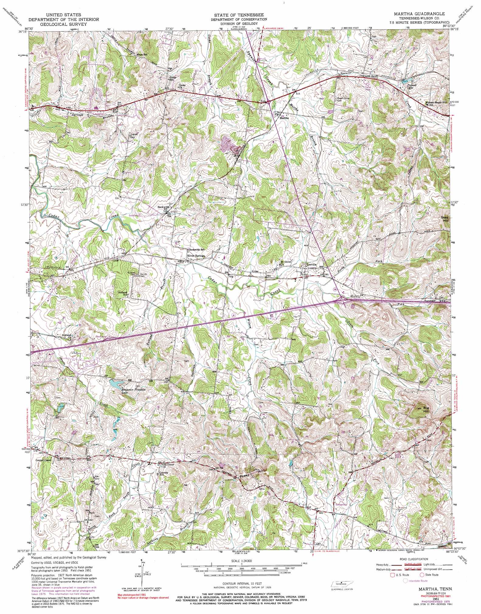
Martha Topo Map Tennessee
To zoom in, hover over the map of Martha
USGS Topo Quad 36086b4 - 1:24,000 scale
| Topo Map Name: | Martha |
| USGS Topo Quad ID: | 36086b4 |
| Print Size: | ca. 21 1/4" wide x 27" high |
| Southeast Coordinates: | 36.125° N latitude / 86.375° W longitude |
| Map Center Coordinates: | 36.1875° N latitude / 86.4375° W longitude |
| U.S. State: | TN |
| Filename: | o36086b4.jpg |
| Download Map JPG Image: | Martha topo map 1:24,000 scale |
| Map Type: | Topographic |
| Topo Series: | 7.5´ |
| Map Scale: | 1:24,000 |
| Source of Map Images: | United States Geological Survey (USGS) |
| Alternate Map Versions: |
Martha TN 1951, updated 1952 Download PDF Buy paper map Martha TN 1951, updated 1967 Download PDF Buy paper map Martha TN 1951, updated 1977 Download PDF Buy paper map Martha TN 1951, updated 1991 Download PDF Buy paper map Martha TN 2010 Download PDF Buy paper map Martha TN 2013 Download PDF Buy paper map Martha TN 2016 Download PDF Buy paper map |
1:24,000 Topo Quads surrounding Martha
White House |
Cottontown |
Gallatin |
Bethpage |
Hartsville |
Goodlettsville |
Hendersonville |
Laguardo |
Hunters Point |
Bellwood |
Nashville East |
Hermitage |
Martha |
Lebanon |
Shop Springs |
Antioch |
La Vergne |
Gladeville |
Vine |
Watertown |
Nolensville |
Smyrna |
Walterhill |
Lascassas |
Milton |
> Back to 36086a1 at 1:100,000 scale
> Back to 36086a1 at 1:250,000 scale
> Back to U.S. Topo Maps home
Martha topo map: Gazetteer
Martha: Crossings
Interchange 232 elevation 184m 603′Martha: Dams
Daniels Lake Dam elevation 188m 616′Martha: Gaps
Tucker Gap elevation 197m 646′Martha: Populated Places
Beckwith elevation 162m 531′Belinda City elevation 179m 587′
Cairo Bend elevation 165m 541′
Leeville elevation 179m 587′
Lindsayville (historical) elevation 195m 639′
Lohmans Store (historical) elevation 184m 603′
Martha elevation 158m 518′
Muncie (historical) elevation 189m 620′
Silver Springs elevation 164m 538′
Tuckers Gap (historical) elevation 201m 659′
Martha: Reservoirs
Benjamin Franklin Lake elevation 199m 652′Daniels Lake elevation 188m 616′
Prowell Lake elevation 179m 587′
Martha: Springs
Horn Spring Number Two elevation 191m 626′Martha: Streams
Martha Branch elevation 153m 501′Middle Fork Cedar Creek elevation 174m 570′
North Fork Cedar Creek elevation 173m 567′
Rutland Branch elevation 158m 518′
South Fork Cedar Creek elevation 174m 570′
Sullivan Branch elevation 160m 524′
Wilson Creek elevation 163m 534′
Martha: Summits
Big Hill elevation 286m 938′Posey Hill elevation 243m 797′
Martha digital topo map on disk
Buy this Martha topo map showing relief, roads, GPS coordinates and other geographical features, as a high-resolution digital map file on DVD: