Hunters Point Topo Map Tennessee
To zoom in, hover over the map of Hunters Point
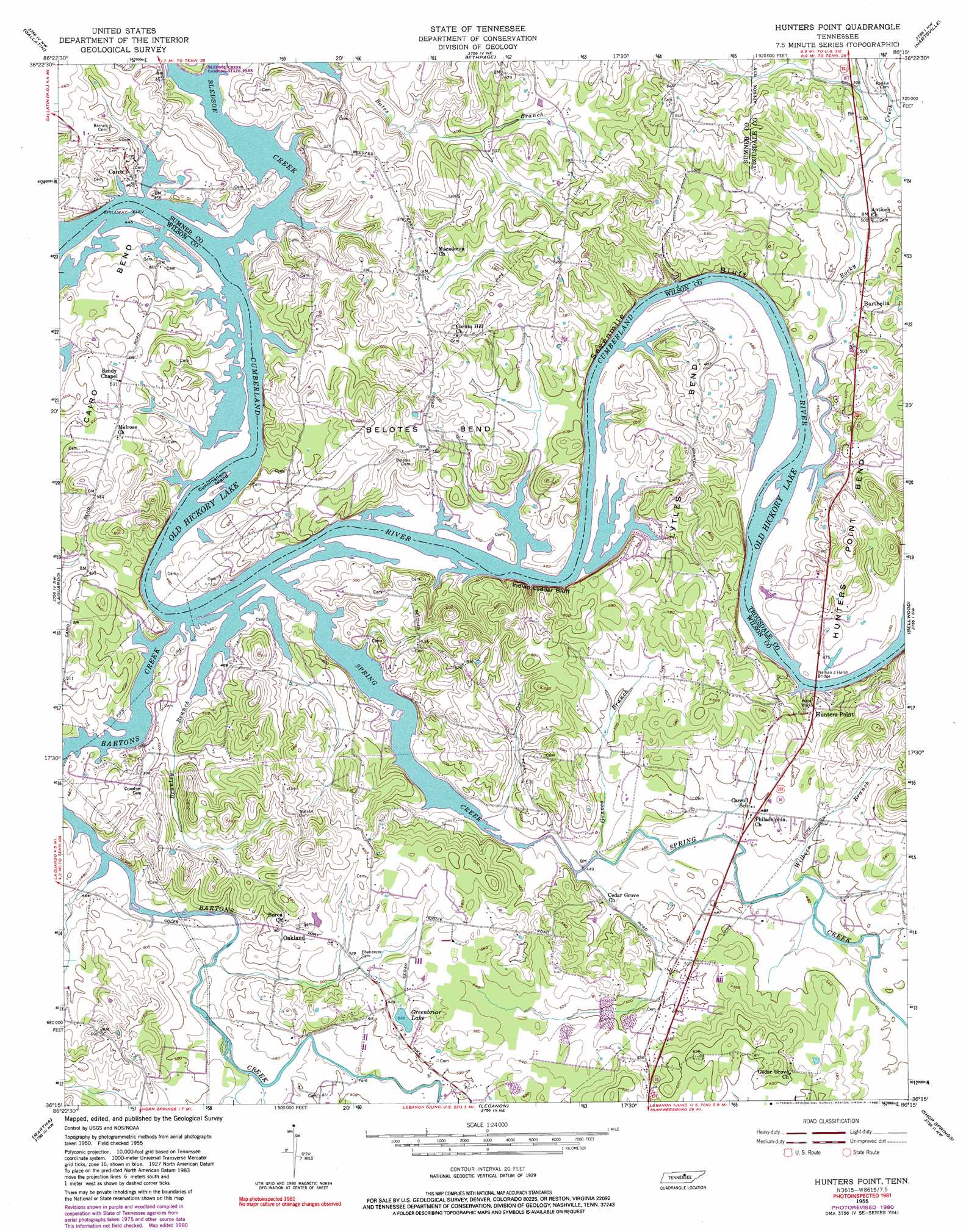
USGS Topo Quad 36086c3 - 1:24,000 scale
| Topo Map Name: | Hunters Point |
| USGS Topo Quad ID: | 36086c3 |
| Print Size: | ca. 21 1/4" wide x 27" high |
| Southeast Coordinates: | 36.25° N latitude / 86.25° W longitude |
| Map Center Coordinates: | 36.3125° N latitude / 86.3125° W longitude |
| U.S. State: | TN |
| Filename: | o36086c3.jpg |
| Download Map JPG Image: | Hunters Point topo map 1:24,000 scale |
| Map Type: | Topographic |
| Topo Series: | 7.5´ |
| Map Scale: | 1:24,000 |
| Source of Map Images: | United States Geological Survey (USGS) |
| Alternate Map Versions: |
Hunters Point TN 1955, updated 1956 Download PDF Buy paper map Hunters Point TN 1955, updated 1973 Download PDF Buy paper map Hunters Point TN 1955, updated 1981 Download PDF Buy paper map Hunters Point TN 1955, updated 1990 Download PDF Buy paper map Hunters Point TN 1994, updated 1997 Download PDF Buy paper map Hunters Point TN 2010 Download PDF Buy paper map Hunters Point TN 2013 Download PDF Buy paper map Hunters Point TN 2016 Download PDF Buy paper map |
1:24,000 Topo Quads surrounding Hunters Point
Portland |
Fountain Head |
Turners Station |
Westmoreland |
Lafayette |
Cottontown |
Gallatin |
Bethpage |
Hartsville |
Hillsdale |
Hendersonville |
Laguardo |
Hunters Point |
Bellwood |
Dixon Springs |
Hermitage |
Martha |
Lebanon |
Shop Springs |
New Middleton |
La Vergne |
Gladeville |
Vine |
Watertown |
Alexandria |
> Back to 36086a1 at 1:100,000 scale
> Back to 36086a1 at 1:250,000 scale
> Back to U.S. Topo Maps home
Hunters Point topo map: Gazetteer
Hunters Point: Bars
Belotes Bar elevation 136m 446′Kings Eddy Bar elevation 136m 446′
Hunters Point: Bends
Belotes Bend elevation 164m 538′Cairo Bend elevation 152m 498′
Hunters Point Bend elevation 179m 587′
Lytles Bend elevation 157m 515′
Hunters Point: Bridges
Nathan J Harsh Bridge elevation 136m 446′Hunters Point: Cliffs
Indian Ladder Bluff elevation 142m 465′Sevenmile Bluff elevation 139m 456′
Hunters Point: Crossings
Belotes Ferry (historical) elevation 136m 446′Belotes Ford (historical) elevation 136m 446′
Cairo Bend Ferry (historical) elevation 136m 446′
Canoe Branch Ferry (historical) elevation 136m 446′
Cunninghams Ford (historical) elevation 136m 446′
Hunters Point Ferry (historical) elevation 136m 446′
Island Ford (historical) elevation 138m 452′
Hunters Point: Islands
Armstrong Island elevation 136m 446′Cunningham Island elevation 140m 459′
Ford Island (historical) elevation 136m 446′
Hunters Point: Parks
Cairo Access Area elevation 138m 452′Hunters Point Access Area elevation 139m 456′
Hunters Point: Populated Places
Antioch elevation 151m 495′Barthelia elevation 146m 479′
Cairo elevation 140m 459′
Ebaneezer (historical) elevation 159m 521′
Hunters Point elevation 153m 501′
Macedonia elevation 158m 518′
Melrose (historical) elevation 157m 515′
Oakland elevation 157m 515′
Odum (historical) elevation 157m 515′
Hunters Point: Reservoirs
Greenbriar Lake elevation 159m 521′Hunters Point: Streams
Bartons Creek elevation 136m 446′Bledsoe Creek elevation 137m 449′
Brunley Branch elevation 136m 446′
Graves Branch elevation 139m 456′
Horn Springs Branch elevation 140m 459′
Palmer Branch elevation 146m 479′
Rocky Creek elevation 136m 446′
Saunders Branch elevation 136m 446′
Spring Creek elevation 136m 446′
Walker Branch elevation 147m 482′
Wilborn Branch elevation 140m 459′
Hunters Point digital topo map on disk
Buy this Hunters Point topo map showing relief, roads, GPS coordinates and other geographical features, as a high-resolution digital map file on DVD: