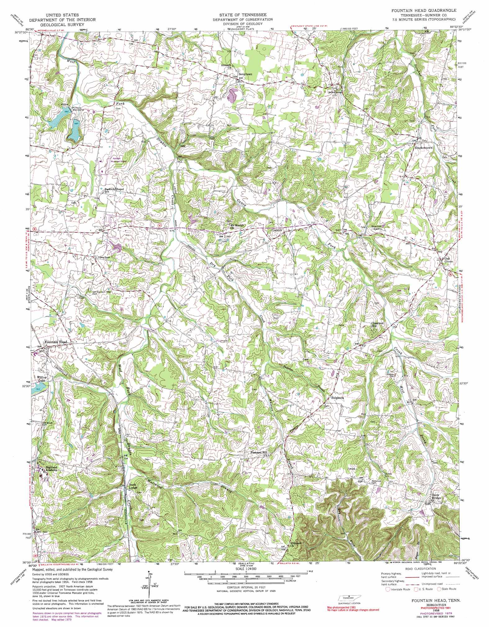
Fountain Head Topo Map Tennessee
To zoom in, hover over the map of Fountain Head
USGS Topo Quad 36086e4 - 1:24,000 scale
| Topo Map Name: | Fountain Head |
| USGS Topo Quad ID: | 36086e4 |
| Print Size: | ca. 21 1/4" wide x 27" high |
| Southeast Coordinates: | 36.5° N latitude / 86.375° W longitude |
| Map Center Coordinates: | 36.5625° N latitude / 86.4375° W longitude |
| U.S. State: | TN |
| Filename: | o36086e4.jpg |
| Download Map JPG Image: | Fountain Head topo map 1:24,000 scale |
| Map Type: | Topographic |
| Topo Series: | 7.5´ |
| Map Scale: | 1:24,000 |
| Source of Map Images: | United States Geological Survey (USGS) |
| Alternate Map Versions: |
Fountain Head TN 1958, updated 1959 Download PDF Buy paper map Fountain Head TN 1958, updated 1992 Download PDF Buy paper map Fountain Head TN 2010 Download PDF Buy paper map Fountain Head TN 2013 Download PDF Buy paper map Fountain Head TN 2016 Download PDF Buy paper map |
1:24,000 Topo Quads surrounding Fountain Head
Auburn |
Woodburn |
Drake |
Allen Springs |
Scottsville |
Prices Mill |
Franklin |
Hickory Flat |
Adolphus |
Petroleum |
Orlinda |
Portland |
Fountain Head |
Turners Station |
Westmoreland |
White House |
Cottontown |
Gallatin |
Bethpage |
Hartsville |
Goodlettsville |
Hendersonville |
Laguardo |
Hunters Point |
Bellwood |
> Back to 36086e1 at 1:100,000 scale
> Back to 36086a1 at 1:250,000 scale
> Back to U.S. Topo Maps home
Fountain Head topo map: Gazetteer
Fountain Head: Airports
Portland Municipal Airport elevation 244m 800′Fountain Head: Dams
Larry Collins Dam elevation 235m 770′Portland City Lake Dam elevation 208m 682′
Sumner County Sportsman Club Lake Dam elevation 209m 685′
Willow Lake Dam elevation 230m 754′
Fountain Head: Populated Places
Brackentown elevation 223m 731′Chestnut Hill elevation 265m 869′
Corinth elevation 234m 767′
Fountain Head elevation 246m 807′
Oak Grove elevation 269m 882′
Pipers Chapel elevation 248m 813′
Rock Bridge elevation 282m 925′
Sengtown elevation 261m 856′
Sulphura elevation 262m 859′
Fountain Head: Reservoirs
Larry Collins Lake elevation 235m 770′Portland City Lake elevation 208m 682′
Sumner Sportsman Club Lake elevation 209m 685′
Willow Lake elevation 230m 754′
Fountain Head: Streams
Caney Fork Creek elevation 200m 656′Dry Fork Creek elevation 203m 666′
Sulphur Branch elevation 227m 744′
Wattwood Branch elevation 221m 725′
West Prong Caney Fork Creek elevation 230m 754′
Whitson Branch elevation 228m 748′
Fountain Head digital topo map on disk
Buy this Fountain Head topo map showing relief, roads, GPS coordinates and other geographical features, as a high-resolution digital map file on DVD: