Ashland City Topo Map Tennessee
To zoom in, hover over the map of Ashland City
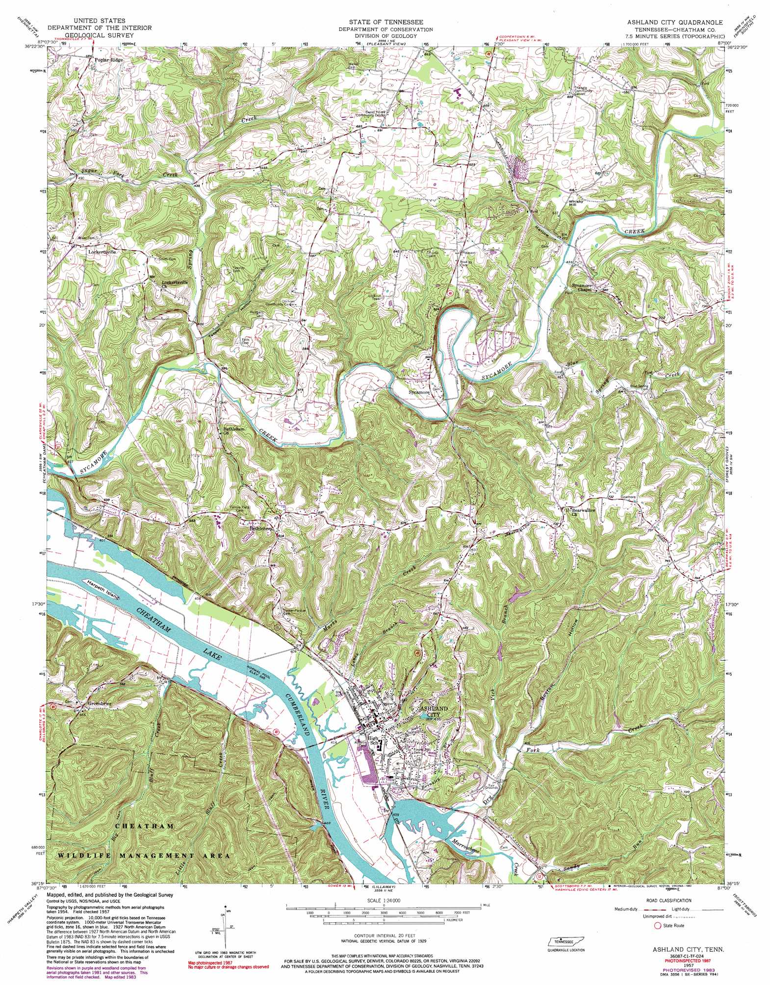
USGS Topo Quad 36087c1 - 1:24,000 scale
| Topo Map Name: | Ashland City |
| USGS Topo Quad ID: | 36087c1 |
| Print Size: | ca. 21 1/4" wide x 27" high |
| Southeast Coordinates: | 36.25° N latitude / 87° W longitude |
| Map Center Coordinates: | 36.3125° N latitude / 87.0625° W longitude |
| U.S. State: | TN |
| Filename: | o36087c1.jpg |
| Download Map JPG Image: | Ashland City topo map 1:24,000 scale |
| Map Type: | Topographic |
| Topo Series: | 7.5´ |
| Map Scale: | 1:24,000 |
| Source of Map Images: | United States Geological Survey (USGS) |
| Alternate Map Versions: |
Ashland City TN 1957, updated 1958 Download PDF Buy paper map Ashland City TN 1957, updated 1973 Download PDF Buy paper map Ashland City TN 1957, updated 1983 Download PDF Buy paper map Ashland City TN 1957, updated 1992 Download PDF Buy paper map Ashland City TN 2010 Download PDF Buy paper map Ashland City TN 2013 Download PDF Buy paper map Ashland City TN 2016 Download PDF Buy paper map |
1:24,000 Topo Quads surrounding Ashland City
Clarksville |
Sango |
Adams |
Springfield North |
Youngville |
Excell |
Henrietta |
Pleasant View |
Springfield South |
Greenbrier |
Cumberland Furnace |
Cheatham Dam |
Ashland City |
Forest Grove |
Whites Creek |
Charlotte |
Harpeth Valley |
Lillamay |
Scottsboro |
Nashville West |
Burns |
White Bluff |
Kingston Springs |
Bellevue |
Oak Hill |
> Back to 36087a1 at 1:100,000 scale
> Back to 36086a1 at 1:250,000 scale
> Back to U.S. Topo Maps home
Ashland City topo map: Gazetteer
Ashland City: Dams
Flax Patch Dam (historical) elevation 117m 383′Ashland City: Islands
Harpeth Island elevation 119m 390′Ashland City: Parks
Big Bluff Creek Access Area elevation 119m 390′Ashland City: Populated Places
Ashland City elevation 130m 426′Bethlehem elevation 184m 603′
Greenbrier elevation 201m 659′
Lockertsville elevation 209m 685′
Sycamore elevation 133m 436′
Ashland City: Ridges
Poplar Ridge elevation 212m 695′Ashland City: Streams
Big Bluff Creek elevation 118m 387′Blue Spring Creek elevation 133m 436′
Boston Hollow Branch elevation 124m 406′
Brinkley Branch elevation 117m 383′
Cobb Hollow Creek elevation 117m 383′
Dry Fork Creek elevation 117m 383′
Lenox Branch elevation 119m 390′
Little Bluff Creek elevation 119m 390′
Marks Creek elevation 117m 383′
Spring Creek elevation 120m 393′
Sugar Fork Creek elevation 131m 429′
Vick Branch elevation 122m 400′
Ashland City: Summits
Whisky Hill elevation 195m 639′Ashland City: Valleys
Boston Hollow elevation 124m 406′Happy Hollow elevation 146m 479′
Slick Hollow elevation 138m 452′
Teasley Hollow elevation 122m 400′
Ashland City digital topo map on disk
Buy this Ashland City topo map showing relief, roads, GPS coordinates and other geographical features, as a high-resolution digital map file on DVD: