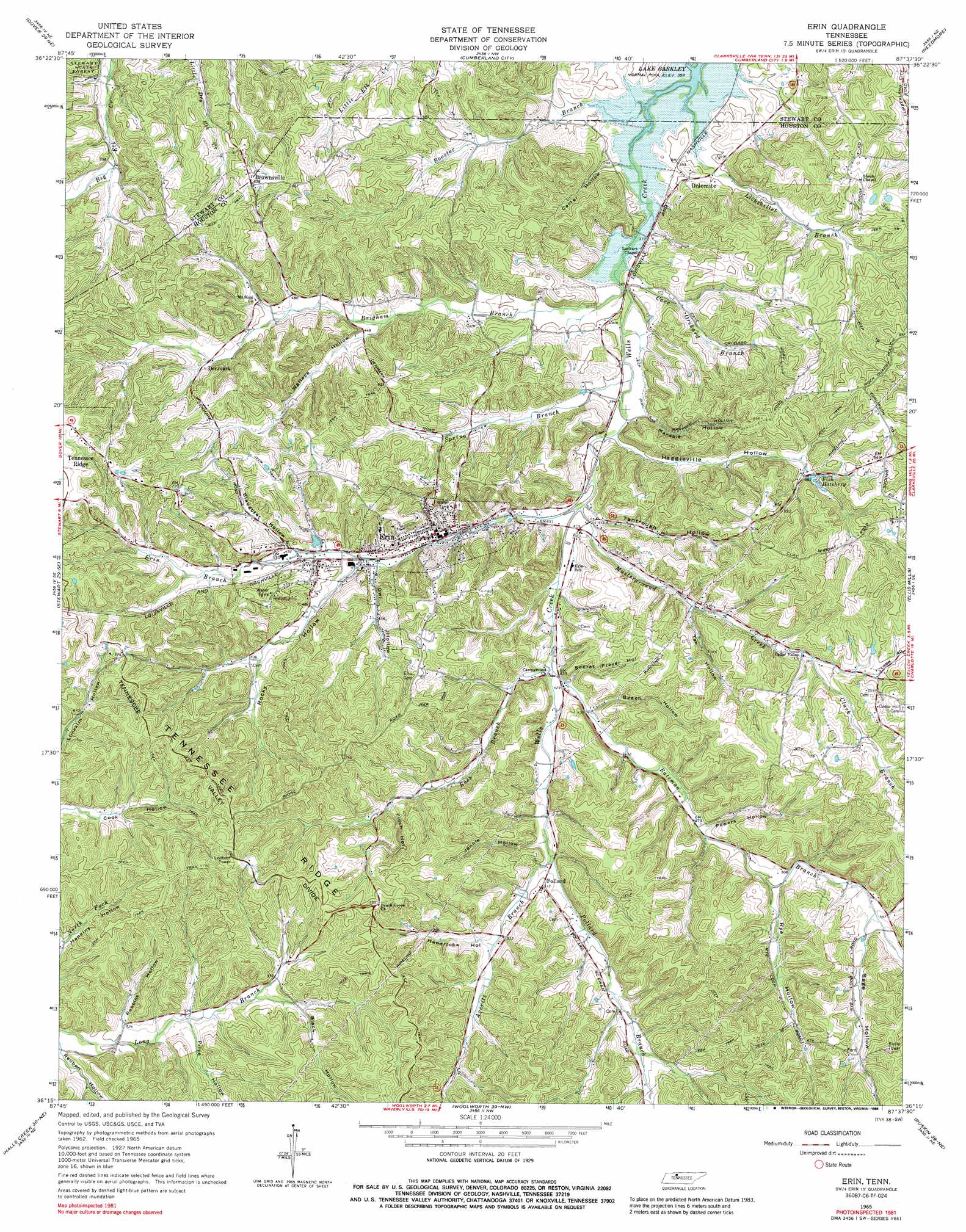
Erin Topo Map Tennessee
To zoom in, hover over the map of Erin
USGS Topo Quad 36087c6 - 1:24,000 scale
| Topo Map Name: | Erin |
| USGS Topo Quad ID: | 36087c6 |
| Print Size: | ca. 21 1/4" wide x 27" high |
| Southeast Coordinates: | 36.25° N latitude / 87.625° W longitude |
| Map Center Coordinates: | 36.3125° N latitude / 87.6875° W longitude |
| U.S. State: | TN |
| Filename: | o36087c6.jpg |
| Download Map JPG Image: | Erin topo map 1:24,000 scale |
| Map Type: | Topographic |
| Topo Series: | 7.5´ |
| Map Scale: | 1:24,000 |
| Source of Map Images: | United States Geological Survey (USGS) |
| Alternate Map Versions: |
Tantrough Hollow TN 1936 Download PDF Buy paper map Erin TN 1965, updated 1966 Download PDF Buy paper map Erin TN 1965, updated 1977 Download PDF Buy paper map Erin TN 1965, updated 1988 Download PDF Buy paper map Erin TN 2010 Download PDF Buy paper map Erin TN 2013 Download PDF Buy paper map Erin TN 2016 Download PDF Buy paper map |
1:24,000 Topo Quads surrounding Erin
Tharpe |
Bumpus Mills |
Indian Mound |
Woodlawn |
New Providence |
Standing Rock |
Dover |
Cumberland City |
Needmore |
Palmyra |
Mckinnon |
Stewart |
Erin |
Ellis Mills |
Slayden |
Harmon Creek |
Halls Creek |
Woolworth |
Ruskin |
Vanleer |
Johnsonville |
Waverly |
Mcewen |
Tennessee City |
Dickson |
> Back to 36087a1 at 1:100,000 scale
> Back to 36086a1 at 1:250,000 scale
> Back to U.S. Topo Maps home
Erin topo map: Gazetteer
Erin: Airports
Schmid Airport elevation 114m 374′Erin: Populated Places
Arlington elevation 157m 515′Brownsville elevation 195m 639′
Denmark elevation 161m 528′
Dolomite elevation 126m 413′
Erin elevation 136m 446′
Midway elevation 138m 452′
Pollard elevation 152m 498′
Erin: Post Offices
Erin Post Office elevation 135m 442′Erin: Ridges
Arlington Ridge elevation 218m 715′Kizer Ridge elevation 175m 574′
Erin: Streams
Averitt Branch elevation 144m 472′Bateman Branch elevation 129m 423′
Booster Branch elevation 109m 357′
Brigham Branch elevation 116m 380′
Cave Orchard Branch elevation 115m 377′
Clark Branch elevation 156m 511′
Erin Branch elevation 121m 396′
Hagerville Branch elevation 119m 390′
Lickskillet Branch elevation 109m 357′
Musterground Creek elevation 121m 396′
Pollard Branch elevation 144m 472′
Ross Branch elevation 129m 423′
Spring Branch elevation 115m 377′
Erin: Valleys
Beech Hollow elevation 133m 436′Black Hollow elevation 174m 570′
Boone Hollow elevation 146m 479′
Carter Hollow elevation 116m 380′
Dobbs Hollow elevation 183m 600′
Finch Hollow elevation 164m 538′
Haggieville Hollow elevation 120m 393′
Hendricks Hollow elevation 159m 521′
Jennie Hollow elevation 145m 475′
Marable Hollow elevation 120m 393′
Owl Hollow elevation 137m 449′
Powers Hollow elevation 145m 475′
Price Hollow elevation 158m 518′
Pulley Hollow elevation 138m 452′
Reuben Hollow elevation 150m 492′
Robbins Hollow elevation 156m 511′
Rocky Hollow elevation 143m 469′
Rye Hollow elevation 152m 498′
Sage Hollow elevation 170m 557′
Schmidt Hollow elevation 114m 374′
Secret Prayer Hollow elevation 131m 429′
Slaughter Hollow elevation 152m 498′
South Moore Hollow elevation 163m 534′
Starspring Hollow elevation 145m 475′
Tab Hollow elevation 135m 442′
Tantrough Hollow elevation 125m 410′
Wallace Hollow elevation 137m 449′
Weaver Hollow elevation 169m 554′
Winters Hollow elevation 153m 501′
Erin digital topo map on disk
Buy this Erin topo map showing relief, roads, GPS coordinates and other geographical features, as a high-resolution digital map file on DVD: