Needmore Topo Map Tennessee
To zoom in, hover over the map of Needmore
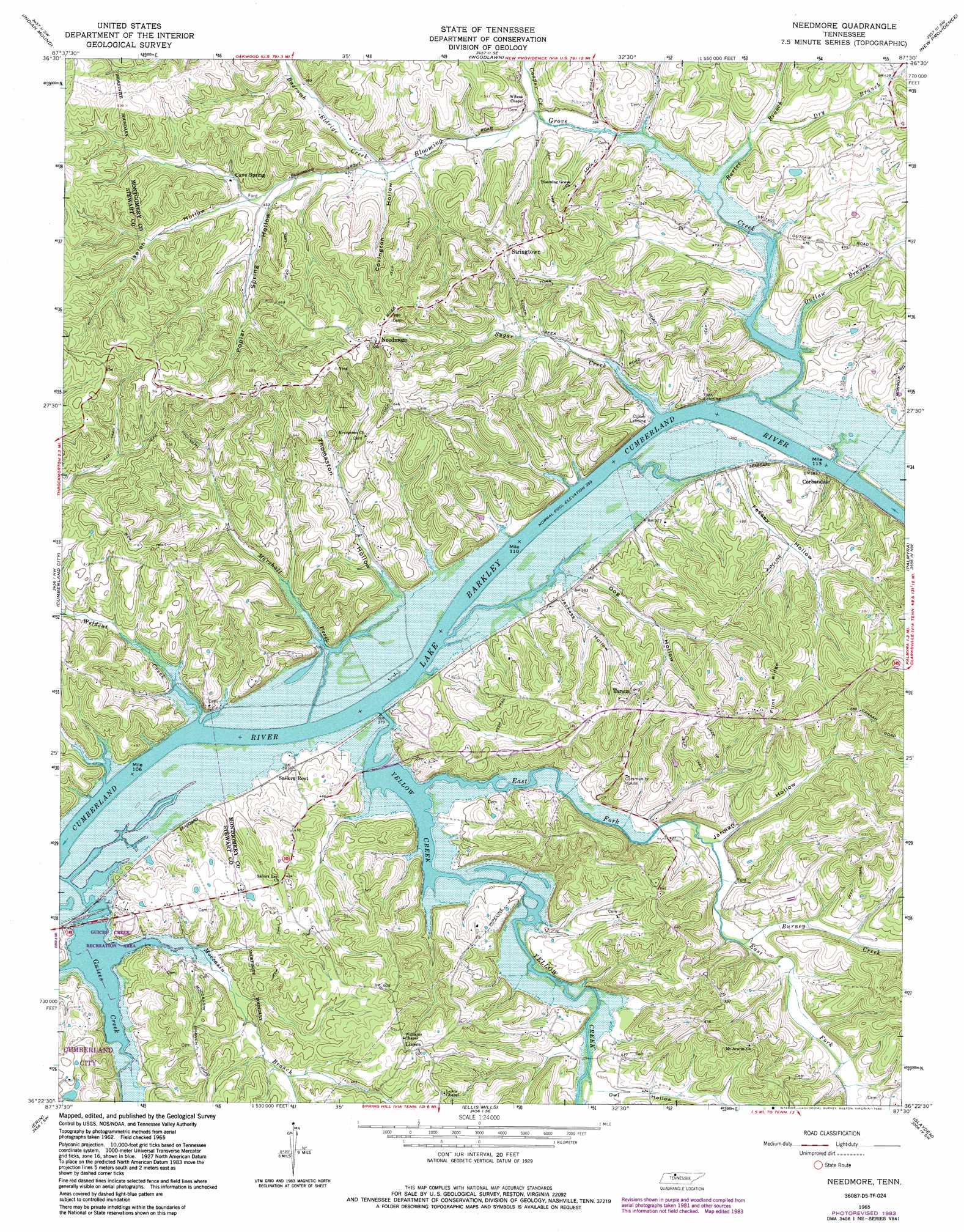
USGS Topo Quad 36087d5 - 1:24,000 scale
| Topo Map Name: | Needmore |
| USGS Topo Quad ID: | 36087d5 |
| Print Size: | ca. 21 1/4" wide x 27" high |
| Southeast Coordinates: | 36.375° N latitude / 87.5° W longitude |
| Map Center Coordinates: | 36.4375° N latitude / 87.5625° W longitude |
| U.S. State: | TN |
| Filename: | o36087d5.jpg |
| Download Map JPG Image: | Needmore topo map 1:24,000 scale |
| Map Type: | Topographic |
| Topo Series: | 7.5´ |
| Map Scale: | 1:24,000 |
| Source of Map Images: | United States Geological Survey (USGS) |
| Alternate Map Versions: |
Needmore TN 1965, updated 1966 Download PDF Buy paper map Needmore TN 1965, updated 1976 Download PDF Buy paper map Needmore TN 1965, updated 1983 Download PDF Buy paper map Needmore TN 2010 Download PDF Buy paper map Needmore TN 2013 Download PDF Buy paper map Needmore TN 2016 Download PDF Buy paper map |
1:24,000 Topo Quads surrounding Needmore
Johnson Hollow |
Roaring Spring |
Herndon |
Oak Grove |
Trenton |
Bumpus Mills |
Indian Mound |
Woodlawn |
New Providence |
Clarksville |
Dover |
Cumberland City |
Needmore |
Palmyra |
Excell |
Stewart |
Erin |
Ellis Mills |
Slayden |
Cumberland Furnace |
Halls Creek |
Woolworth |
Ruskin |
Vanleer |
Charlotte |
> Back to 36087a1 at 1:100,000 scale
> Back to 36086a1 at 1:250,000 scale
> Back to U.S. Topo Maps home
Needmore topo map: Gazetteer
Needmore: Bars
Yellow Creek Tow Head elevation 107m 351′Needmore: Dams
Lock C (historical) elevation 107m 351′Needmore: Parks
Guices Creek Recreation Area elevation 115m 377′Needmore: Populated Places
Bellamy (historical) elevation 125m 410′Cave Spring elevation 155m 508′
Corbandale elevation 139m 456′
Liners elevation 184m 603′
Needmore elevation 213m 698′
New York (historical) elevation 143m 469′
Stringtown elevation 199m 652′
Tarsus elevation 182m 597′
Needmore: Ridges
Flint Ridge elevation 191m 626′Gunson Ridge elevation 179m 587′
Needmore: Streams
Bartee Branch elevation 111m 364′Bascomb Eldrige Creek elevation 125m 410′
Bear Creek elevation 110m 360′
Blooming Grove Creek elevation 109m 357′
Burney Creek elevation 121m 396′
Cooper Creek elevation 116m 380′
Dry Branch elevation 112m 367′
East Fork Yellow Creek elevation 107m 351′
Guices Creek elevation 110m 360′
Marshall Creek elevation 109m 357′
Moccasin Branch elevation 107m 351′
Outlaw Branch elevation 108m 354′
Sugar Creek elevation 109m 357′
Wildcat Creek elevation 107m 351′
Yellow Creek elevation 108m 354′
Needmore: Valleys
Bowling Green Hollow elevation 107m 351′Covington Hollow elevation 127m 416′
Dog Hollow elevation 116m 380′
Fessey Hollow elevation 114m 374′
Isaiah Hollow elevation 137m 449′
Jackass Hollow elevation 113m 370′
Jarman Hollow elevation 119m 390′
Newman Hollow elevation 145m 475′
Owl Hollow elevation 121m 396′
Poplar Spring Hollow elevation 137m 449′
Schuff Hollow elevation 119m 390′
Thomaston Hollow elevation 115m 377′
Needmore digital topo map on disk
Buy this Needmore topo map showing relief, roads, GPS coordinates and other geographical features, as a high-resolution digital map file on DVD: