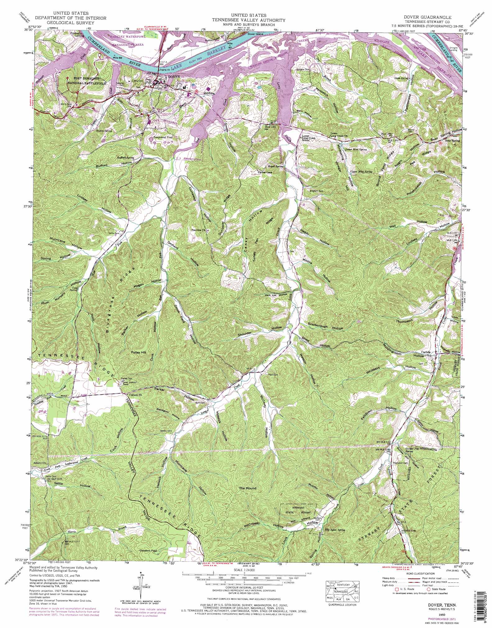
Dover Topo Map Tennessee
To zoom in, hover over the map of Dover
USGS Topo Quad 36087d7 - 1:24,000 scale
| Topo Map Name: | Dover |
| USGS Topo Quad ID: | 36087d7 |
| Print Size: | ca. 21 1/4" wide x 27" high |
| Southeast Coordinates: | 36.375° N latitude / 87.75° W longitude |
| Map Center Coordinates: | 36.4375° N latitude / 87.8125° W longitude |
| U.S. State: | TN |
| Filename: | o36087d7.jpg |
| Download Map JPG Image: | Dover topo map 1:24,000 scale |
| Map Type: | Topographic |
| Topo Series: | 7.5´ |
| Map Scale: | 1:24,000 |
| Source of Map Images: | United States Geological Survey (USGS) |
| Alternate Map Versions: |
Dover TN 1936 Download PDF Buy paper map Dover TN 1950, updated 1954 Download PDF Buy paper map Dover TN 1950, updated 1968 Download PDF Buy paper map Dover TN 1950, updated 1972 Download PDF Buy paper map Dover TN 1950, updated 1972 Download PDF Buy paper map Dover TN 2010 Download PDF Buy paper map Dover TN 2013 Download PDF Buy paper map Dover TN 2016 Download PDF Buy paper map |
1:24,000 Topo Quads surrounding Dover
Rushing Creek |
Linton |
Johnson Hollow |
Roaring Spring |
Herndon |
Hamlin |
Tharpe |
Bumpus Mills |
Indian Mound |
Woodlawn |
Paris Landing |
Standing Rock |
Dover |
Cumberland City |
Needmore |
Poplar Creek |
Mckinnon |
Stewart |
Erin |
Ellis Mills |
Big Sandy |
Harmon Creek |
Halls Creek |
Woolworth |
Ruskin |
> Back to 36087a1 at 1:100,000 scale
> Back to 36086a1 at 1:250,000 scale
> Back to U.S. Topo Maps home
Dover topo map: Gazetteer
Dover: Bridges
Sidney C Lewis Highway Bridge elevation 107m 351′Dover: Dams
Lock D (historical) elevation 107m 351′Dover: Flats
Pulley Field elevation 138m 452′Dover: Forests
Stewart State Forest elevation 187m 613′Dover: Lakes
Fairground Pond elevation 153m 501′Dover: Mines
Grave Yard Bank Mine elevation 147m 482′Grave Yard Ore Bank elevation 154m 505′
Hotel Ore Bank elevation 158m 518′
Potatopatch Hollow Mine elevation 160m 524′
Skunk Hollow Mines elevation 173m 567′
Skunk Hollow Ore Banks elevation 167m 547′
Dover: Parks
Barkley Wildlife Management Area elevation 110m 360′Dover Access Point elevation 109m 357′
Fort Donelson National Battlefield elevation 133m 436′
Hickman Creek Recreation Area elevation 115m 377′
Lick Creek Recreation Area elevation 117m 383′
Dover: Populated Places
Bear Spring elevation 123m 403′Carlisle elevation 118m 387′
Dover elevation 126m 413′
Dover: Ridges
Bluegrass Ridge elevation 183m 600′Dunaway Ridge elevation 173m 567′
Pea Ridge elevation 177m 580′
Round Pond Ridge elevation 191m 626′
Turkey Pen Ridge elevation 165m 541′
Dover: Springs
Boyett Spring elevation 113m 370′Bufford Spring elevation 127m 416′
Carlisle Spring elevation 124m 406′
Cold Spring elevation 140m 459′
Guinea Jim Spring elevation 141m 462′
Gum Spring elevation 116m 380′
Lower Mint Spring elevation 144m 472′
Old Sykes Spring elevation 151m 495′
Sexton Spring elevation 122m 400′
Upper Mint Spring elevation 159m 521′
Dover: Streams
Cross Creek elevation 133m 436′Dry Branch elevation 109m 357′
Dyers Creek elevation 107m 351′
East Fork Lick Creek elevation 118m 387′
Hickman Creek elevation 107m 351′
Indian Creek elevation 107m 351′
Lick Creek elevation 107m 351′
Long Creek elevation 107m 351′
North Cross Creek elevation 133m 436′
West Fork Lick Creek elevation 119m 390′
Dover: Summits
Pulley Hill elevation 197m 646′The Mound elevation 215m 705′
Vinegar Hill elevation 166m 544′
Dover: Swamps
Chambers Pond elevation 212m 695′Dover: Valleys
Barn Hollow elevation 116m 380′Barn Hollow elevation 107m 351′
Blackgum Hollow elevation 155m 508′
Bufford Hollow elevation 119m 390′
Caney Hollow elevation 115m 377′
Cook Hollow elevation 171m 561′
Cook Hollow elevation 145m 475′
Coon Hollow elevation 119m 390′
Crook Field Hollow elevation 139m 456′
Dunaway Hollow elevation 118m 387′
Erin Hollow elevation 115m 377′
Felldown Hollow elevation 128m 419′
Gatin Hollow elevation 132m 433′
Guinea Jim Hollow elevation 132m 433′
Heddy Hollow elevation 128m 419′
Helwick Hollow elevation 161m 528′
Helwick Hollow elevation 147m 482′
Hildreth Hollow elevation 119m 390′
Hogan Hollow elevation 133m 436′
Hurricane Hollow elevation 171m 561′
Hurricane Hollow elevation 137m 449′
Jack Lot Hollow elevation 122m 400′
Lindsey Hollow elevation 114m 374′
Lindsey Hollow elevation 126m 413′
Louis Hollow elevation 152m 498′
McCarty Hollow elevation 139m 456′
McCrowey Hollow elevation 162m 531′
McGiffin Hollow elevation 146m 479′
Mintspring Hollow elevation 126m 413′
Moldingroom Hollow elevation 126m 413′
Moore Hollow elevation 123m 403′
Negro Hollow elevation 136m 446′
Newground Hollow elevation 140m 459′
Orchard Hollow elevation 129m 423′
Orchard Hollow elevation 115m 377′
Parker Hollow elevation 143m 469′
Parker Hollow elevation 146m 479′
Peapatch Hollow elevation 110m 360′
Plum Nursery Hollow elevation 139m 456′
Rattlesnake Hollow elevation 112m 367′
Rattlesnake Hollow elevation 111m 364′
Rock Hollow elevation 151m 495′
Scarborough Hollow elevation 133m 436′
Settle Hollow elevation 151m 495′
Shaw Hollow elevation 133m 436′
Shoulder Hollow elevation 130m 426′
Smith Hollow elevation 108m 354′
Spring Hollow elevation 143m 469′
Spring Hollow elevation 151m 495′
Thompson Hollow elevation 116m 380′
Watson Hollow elevation 133m 436′
Well Hollow elevation 116m 380′
Whitedirt Hollow elevation 121m 396′
Dover digital topo map on disk
Buy this Dover topo map showing relief, roads, GPS coordinates and other geographical features, as a high-resolution digital map file on DVD: