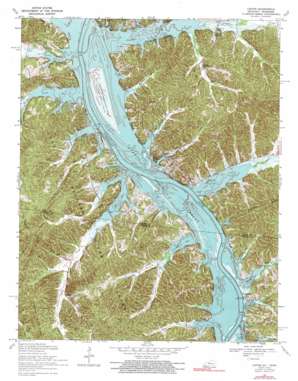
Linton Topo Map Kentucky
To zoom in, hover over the map of Linton
USGS Topo Quad 36087f8 - 1:24,000 scale
| Topo Map Name: | Linton |
| USGS Topo Quad ID: | 36087f8 |
| Print Size: | ca. 21 1/4" wide x 27" high |
| Southeast Coordinates: | 36.625° N latitude / 87.875° W longitude |
| Map Center Coordinates: | 36.6875° N latitude / 87.9375° W longitude |
| U.S. States: | KY, TN |
| Filename: | o36087f8.jpg |
| Download Map JPG Image: | Linton topo map 1:24,000 scale |
| Map Type: | Topographic |
| Topo Series: | 7.5´ |
| Map Scale: | 1:24,000 |
| Source of Map Images: | United States Geological Survey (USGS) |
| Alternate Map Versions: |
Model KY 1951, updated 1953 Download PDF Buy paper map Model KY 1957, updated 1960 Download PDF Buy paper map Linton KY 1967, updated 1970 Download PDF Buy paper map Linton KY 1967, updated 1991 Download PDF Buy paper map Linton KY 2011 Download PDF Buy paper map Linton KY 2013 Download PDF Buy paper map Linton KY 2016 Download PDF Buy paper map |
| FStopo: | US Forest Service topo Linton is available: Download FStopo PDF Download FStopo TIF |
1:24,000 Topo Quads surrounding Linton
> Back to 36087e1 at 1:100,000 scale
> Back to 36086a1 at 1:250,000 scale
> Back to U.S. Topo Maps home
Linton topo map: Gazetteer
Linton: Bays
Crockett Bay elevation 107m 351′Fords Bay elevation 107m 351′
Pryor Bay elevation 107m 351′
Pryor Bay elevation 107m 351′
Linton: Parks
Calhoun Hill Public Use Area elevation 107m 351′Donaldson Creek Public Use Area elevation 116m 380′
Linton Public Use Area elevation 107m 351′
Tobaccoport Public Use Area elevation 115m 377′
Linton: Populated Places
Linton elevation 117m 383′Tobaccoport elevation 115m 377′
Linton: Ridges
Fox Ridge elevation 133m 436′Fox Ridge elevation 142m 465′
Linton: Springs
Big Joe Spring elevation 110m 360′Shelby Spring elevation 115m 377′
Turner Spring elevation 127m 416′
Linton: Streams
Acree Creek elevation 107m 351′Big Hurricane Creek elevation 107m 351′
Craig Branch elevation 109m 357′
Crockett Branch elevation 110m 360′
Crockett Creek elevation 107m 351′
Donaldson Creek elevation 107m 351′
Downs Branch elevation 119m 390′
Dry Creek elevation 112m 367′
Fords Creek elevation 110m 360′
Laura Furnace Creek elevation 112m 367′
Lick Creek elevation 107m 351′
Little Hurricane Creek elevation 107m 351′
Parsons Creek elevation 108m 354′
Pinner Spring Branch elevation 107m 351′
Powell Branch elevation 107m 351′
Pryor Creek elevation 110m 360′
Pryor Creek elevation 107m 351′
Rat Branch elevation 122m 400′
Ross Branch elevation 107m 351′
Rowlett Branch elevation 107m 351′
Saline Creek elevation 107m 351′
Shelby Creek elevation 107m 351′
Terrapin Creek elevation 109m 357′
West Fork Laura Furnace Creek elevation 110m 360′
Linton: Trails
Buffalo Trail elevation 136m 446′Linton: Valleys
Williams Hollow elevation 110m 360′Linton digital topo map on disk
Buy this Linton topo map showing relief, roads, GPS coordinates and other geographical features, as a high-resolution digital map file on DVD:


