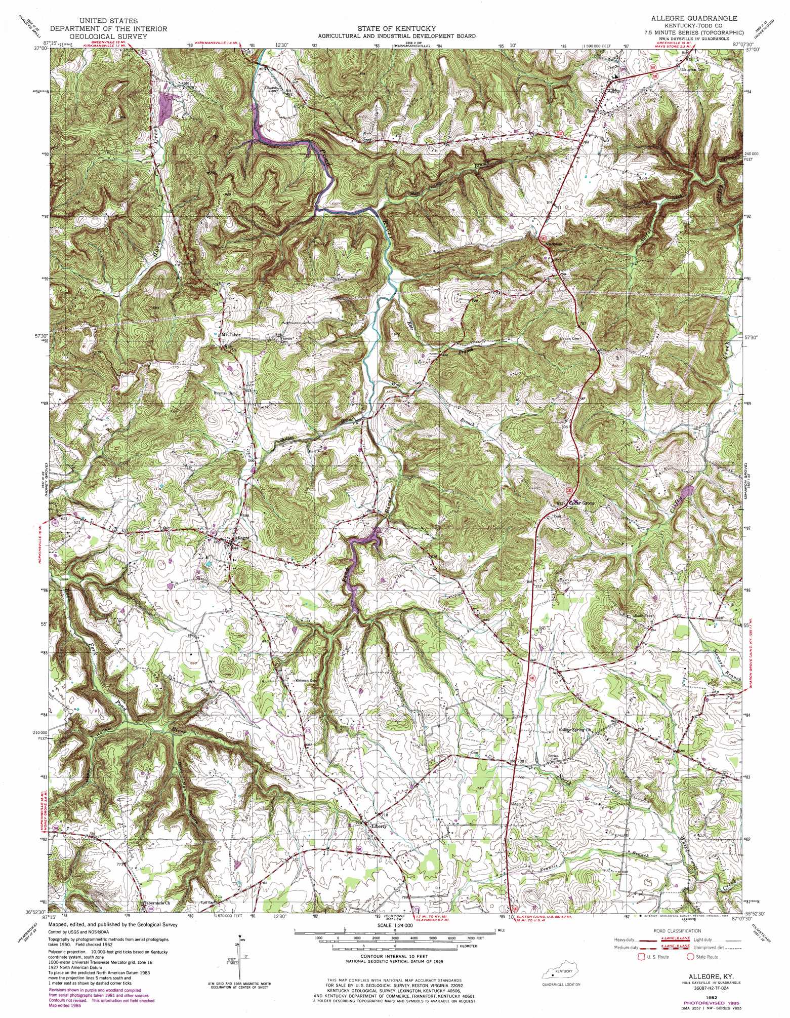
Allegre Topo Map Kentucky
To zoom in, hover over the map of Allegre
USGS Topo Quad 36087h2 - 1:24,000 scale
| Topo Map Name: | Allegre |
| USGS Topo Quad ID: | 36087h2 |
| Print Size: | ca. 21 1/4" wide x 27" high |
| Southeast Coordinates: | 36.875° N latitude / 87.125° W longitude |
| Map Center Coordinates: | 36.9375° N latitude / 87.1875° W longitude |
| U.S. State: | KY |
| Filename: | o36087h2.jpg |
| Download Map JPG Image: | Allegre topo map 1:24,000 scale |
| Map Type: | Topographic |
| Topo Series: | 7.5´ |
| Map Scale: | 1:24,000 |
| Source of Map Images: | United States Geological Survey (USGS) |
| Alternate Map Versions: |
Allegre KY 1952, updated 1953 Download PDF Buy paper map Allegre KY 1952, updated 1982 Download PDF Buy paper map Allegre KY 1952, updated 1985 Download PDF Buy paper map Allegre KY 2010 Download PDF Buy paper map Allegre KY 2013 Download PDF Buy paper map Allegre KY 2016 Download PDF Buy paper map |
1:24,000 Topo Quads surrounding Allegre
Nortonville |
Graham |
Greenville |
Drakesboro |
Rochester |
Crofton |
Haleys Mill |
Kirkmansville |
Rosewood |
Dunmor |
Kelly |
Honey Grove |
Allegre |
Sharon Grove |
Lewisburg |
Hopkinsville |
Pembroke |
Elkton |
Olmstead |
Russellville |
Oak Grove |
Trenton |
Guthrie |
Allensville |
Dot |
> Back to 36087e1 at 1:100,000 scale
> Back to 36086a1 at 1:250,000 scale
> Back to U.S. Topo Maps home
Allegre topo map: Gazetteer
Allegre: Gaps
Narrows elevation 235m 770′Allegre: Populated Places
Allegre elevation 196m 643′Cedar Grove elevation 250m 820′
Clifty elevation 247m 810′
Liberty elevation 217m 711′
Mount Tabor elevation 233m 764′
Allegre: Streams
Francis Branch elevation 197m 646′Kate Branch elevation 162m 531′
Shelton Branch elevation 153m 501′
Slim Jimmy Branch elevation 153m 501′
Sulfur Lick elevation 152m 498′
Wolf Branch elevation 149m 488′
Allegre: Valleys
Dead Man Hollow elevation 163m 534′Happy Hollow elevation 159m 521′
Allegre digital topo map on disk
Buy this Allegre topo map showing relief, roads, GPS coordinates and other geographical features, as a high-resolution digital map file on DVD: