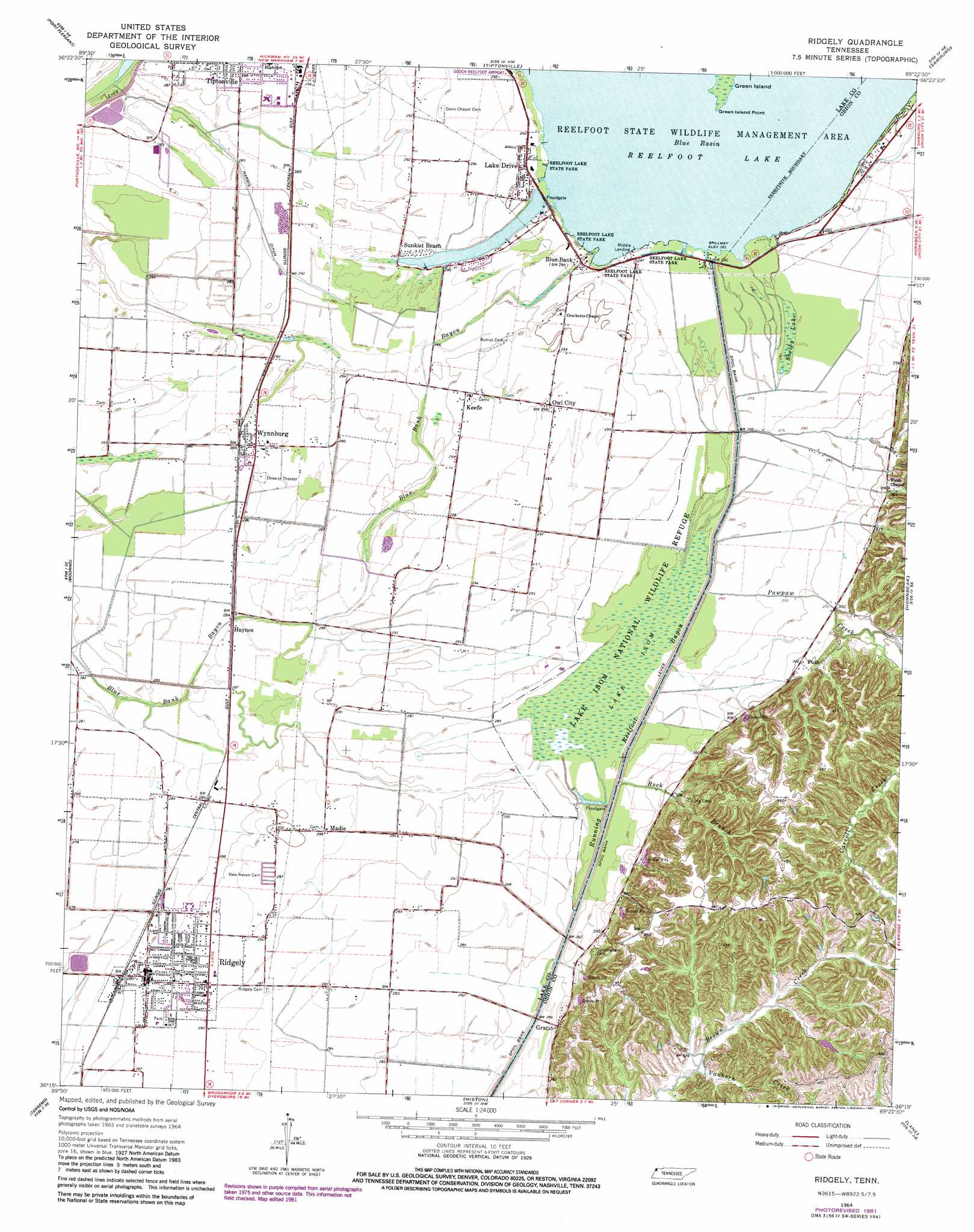
Ridgely Topo Map Tennessee
To zoom in, hover over the map of Ridgely
USGS Topo Quad 36089c4 - 1:24,000 scale
| Topo Map Name: | Ridgely |
| USGS Topo Quad ID: | 36089c4 |
| Print Size: | ca. 21 1/4" wide x 27" high |
| Southeast Coordinates: | 36.25° N latitude / 89.375° W longitude |
| Map Center Coordinates: | 36.3125° N latitude / 89.4375° W longitude |
| U.S. State: | TN |
| Filename: | o36089c4.jpg |
| Download Map JPG Image: | Ridgely topo map 1:24,000 scale |
| Map Type: | Topographic |
| Topo Series: | 7.5´ |
| Map Scale: | 1:24,000 |
| Source of Map Images: | United States Geological Survey (USGS) |
| Alternate Map Versions: |
Ridgely TN 1964, updated 1965 Download PDF Buy paper map Ridgely TN 1964, updated 1981 Download PDF Buy paper map Ridgely TN 2010 Download PDF Buy paper map Ridgely TN 2013 Download PDF Buy paper map Ridgely TN 2016 Download PDF Buy paper map |
1:24,000 Topo Quads surrounding Ridgely
Catron |
New Madrid |
Hubbard Lake |
Bondurant |
Hickman |
Portageville |
Point Pleasant |
Tiptonville |
Samburg |
Clayton |
Stanley |
Mooring |
Ridgely |
Hornbeak |
Obion |
Caruthersville |
Tennemo |
Miston |
Lane |
Trimble |
Cottonwood Point |
Caruthersville Se |
Dyersburg |
Newbern |
Tatumville |
> Back to 36089a1 at 1:100,000 scale
> Back to 36088a1 at 1:250,000 scale
> Back to U.S. Topo Maps home
Ridgely topo map: Gazetteer
Ridgely: Airports
Gooch Reelfoot Airport elevation 90m 295′Ridgely: Bays
Glory Hole elevation 86m 282′Half Moon Basin elevation 86m 282′
Lids Pocket elevation 87m 285′
Magic Hole elevation 86m 282′
Ridgely: Canals
Harris Ditch elevation 84m 275′Ridgely: Capes
Campbells Point elevation 86m 282′Green Island Point elevation 87m 285′
Spain Point elevation 87m 285′
Ridgely: Dams
Reelfoot Lake Outlet at Spillway elevation 86m 282′Ridgely: Guts
Blue Bank Bayou elevation 87m 285′Box Slough elevation 86m 282′
Broad Slough elevation 85m 278′
Ridgely: Lakes
Blue Basin elevation 86m 282′Reelfoot Lake elevation 86m 282′
Ridgely: Levees
Blue Bank Levee elevation 88m 288′Ridgely: Parks
Agnes McCutchen Park elevation 87m 285′Lake County Recreational Park elevation 87m 285′
Lake Isom National Wildlife Refuge elevation 85m 278′
Reelfoot Lake State Park elevation 86m 282′
Ridgely: Populated Places
Blue Bank elevation 88m 288′Edgewater Beach elevation 88m 288′
Gratio elevation 91m 298′
Haynes elevation 86m 282′
Keefe elevation 89m 291′
Lake Drive elevation 89m 291′
Madie elevation 91m 298′
Magnolia Beach elevation 89m 291′
Owl City elevation 90m 295′
Ridgely elevation 86m 282′
Sunkist Beach elevation 87m 285′
Webb Chapel elevation 94m 308′
Wynnburg elevation 88m 288′
Ridgely: Post Offices
Ridgely Post Office elevation 87m 285′Wynnburg Post Office elevation 87m 285′
Ridgely: Streams
Carroll Creek elevation 89m 291′Pawpaw Creek elevation 80m 262′
Rock Branch elevation 79m 259′
Vanhorn Creek elevation 97m 318′
Ridgely: Swamps
Lake Isom elevation 85m 278′Shelby Lake elevation 85m 278′
Ridgely digital topo map on disk
Buy this Ridgely topo map showing relief, roads, GPS coordinates and other geographical features, as a high-resolution digital map file on DVD: