Mooring Topo Map Tennessee
To zoom in, hover over the map of Mooring
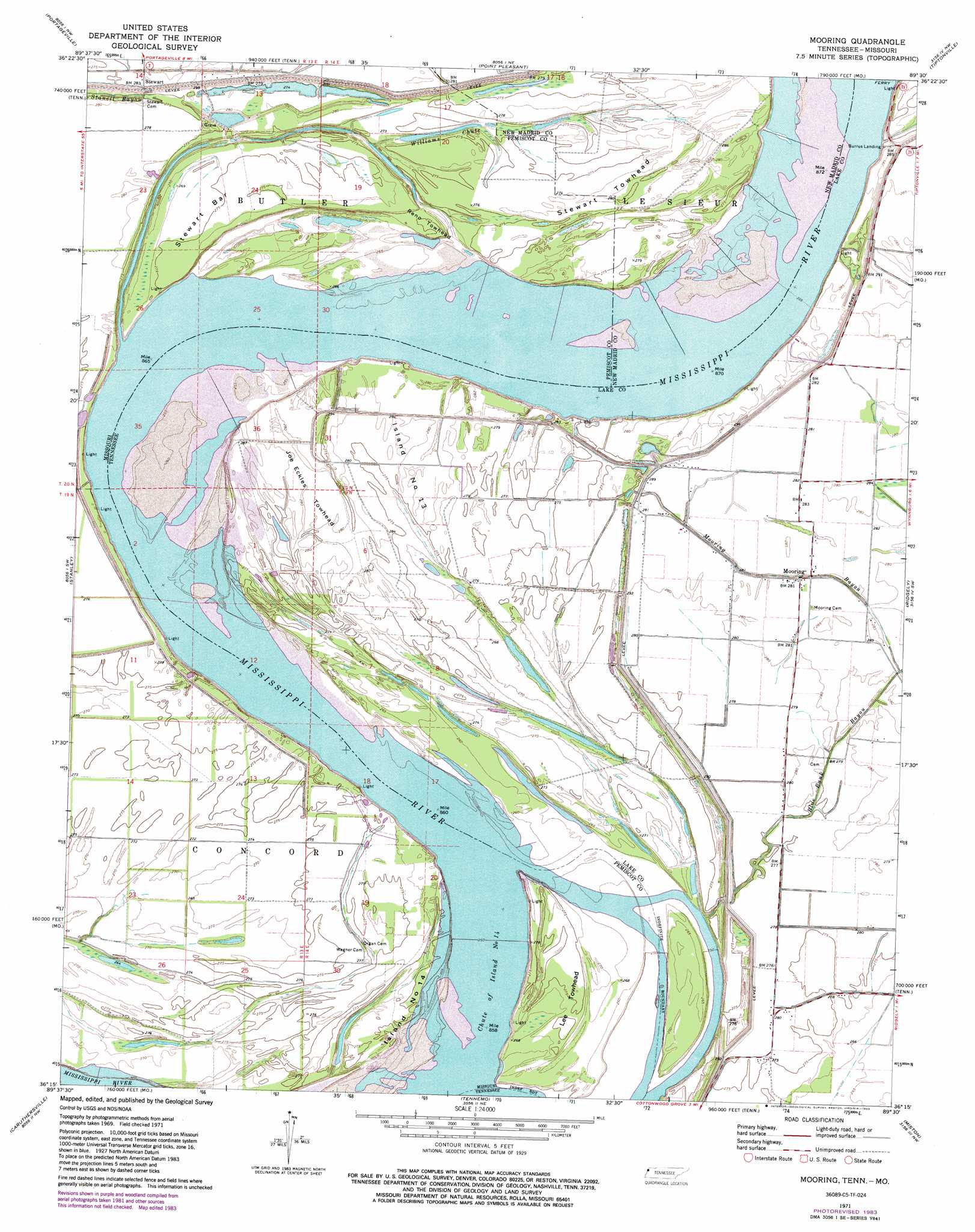
USGS Topo Quad 36089c5 - 1:24,000 scale
| Topo Map Name: | Mooring |
| USGS Topo Quad ID: | 36089c5 |
| Print Size: | ca. 21 1/4" wide x 27" high |
| Southeast Coordinates: | 36.25° N latitude / 89.5° W longitude |
| Map Center Coordinates: | 36.3125° N latitude / 89.5625° W longitude |
| U.S. States: | TN, MO |
| Filename: | o36089c5.jpg |
| Download Map JPG Image: | Mooring topo map 1:24,000 scale |
| Map Type: | Topographic |
| Topo Series: | 7.5´ |
| Map Scale: | 1:24,000 |
| Source of Map Images: | United States Geological Survey (USGS) |
| Alternate Map Versions: |
Mooring TN 1971, updated 1973 Download PDF Buy paper map Mooring TN 1971, updated 1983 Download PDF Buy paper map Mooring TN 2010 Download PDF Buy paper map Mooring TN 2013 Download PDF Buy paper map Mooring TN 2016 Download PDF Buy paper map |
1:24,000 Topo Quads surrounding Mooring
Parma |
Catron |
New Madrid |
Hubbard Lake |
Bondurant |
Boekerton |
Portageville |
Point Pleasant |
Tiptonville |
Samburg |
Wardell |
Stanley |
Mooring |
Ridgely |
Hornbeak |
Hayti Heights |
Caruthersville |
Tennemo |
Miston |
Lane |
Steele |
Cottonwood Point |
Caruthersville Se |
Dyersburg |
Newbern |
> Back to 36089a1 at 1:100,000 scale
> Back to 36088a1 at 1:250,000 scale
> Back to U.S. Topo Maps home
Mooring topo map: Gazetteer
Mooring: Areas
Reno Towhead elevation 84m 275′Stewart Towhead elevation 86m 282′
Mooring: Bars
Alaska Light Bar elevation 77m 252′Stewart Bar elevation 84m 275′
Mooring: Bends
Bend of Island Number Fourteen elevation 76m 249′Little Cypress Bend elevation 77m 252′
Little Cypress Bend elevation 77m 252′
Merriwether Bend elevation 77m 252′
Mooring: Channels
Chute of Island Number 14 elevation 76m 249′Mooring: Dams
Rons Dam elevation 89m 291′Mooring: Flats
Island Number Thirteen elevation 85m 278′Joe Eckles Towhead elevation 85m 278′
Peacock Field elevation 86m 282′
Mooring: Guts
Mooring Bayou elevation 85m 278′Mooring: Islands
Island Number 14 elevation 82m 269′Lee Towhead elevation 85m 278′
Mooring: Lakes
Williams Chute elevation 81m 265′Mooring: Levees
Bend of Island Number Fourteen Revetment elevation 76m 249′Head of Island Number Thirteen Dikes elevation 78m 255′
Lee Towhead Revetment elevation 81m 265′
Merriwether-Cherokee Revetment elevation 84m 275′
Mooring: Populated Places
Fourteen Bend (historical) elevation 84m 275′Kennedy elevation 84m 275′
Mooring elevation 86m 282′
Stewart elevation 85m 278′
Mooring: Ridges
Sheep Ridge elevation 85m 278′Mooring: Streams
Old Graveyard Slough elevation 82m 269′Mooring digital topo map on disk
Buy this Mooring topo map showing relief, roads, GPS coordinates and other geographical features, as a high-resolution digital map file on DVD: