Tiptonville Topo Map Tennessee
To zoom in, hover over the map of Tiptonville
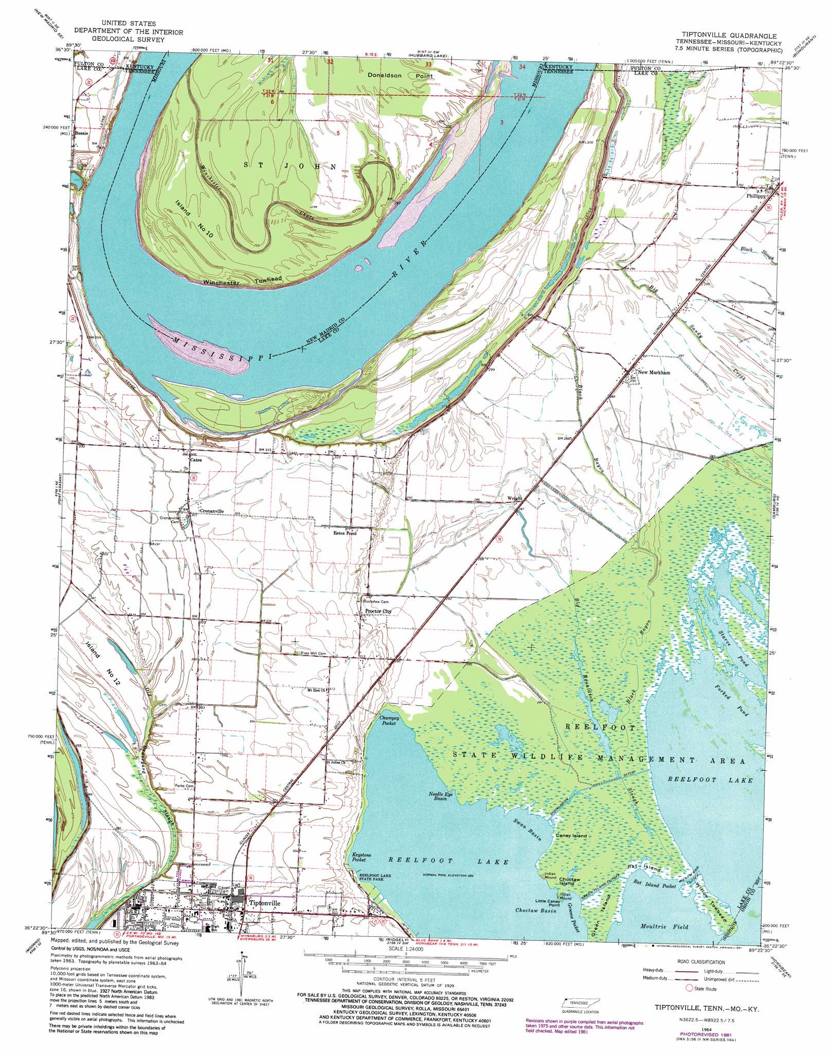
USGS Topo Quad 36089d4 - 1:24,000 scale
| Topo Map Name: | Tiptonville |
| USGS Topo Quad ID: | 36089d4 |
| Print Size: | ca. 21 1/4" wide x 27" high |
| Southeast Coordinates: | 36.375° N latitude / 89.375° W longitude |
| Map Center Coordinates: | 36.4375° N latitude / 89.4375° W longitude |
| U.S. States: | TN, KY, MO |
| Filename: | o36089d4.jpg |
| Download Map JPG Image: | Tiptonville topo map 1:24,000 scale |
| Map Type: | Topographic |
| Topo Series: | 7.5´ |
| Map Scale: | 1:24,000 |
| Source of Map Images: | United States Geological Survey (USGS) |
| Alternate Map Versions: |
Tiptonville TN 1964, updated 1965 Download PDF Buy paper map Tiptonville TN 1964, updated 1981 Download PDF Buy paper map Tiptonville TN 2010 Download PDF Buy paper map Tiptonville TN 2013 Download PDF Buy paper map Tiptonville TN 2016 Download PDF Buy paper map |
1:24,000 Topo Quads surrounding Tiptonville
Charter Oak |
Kewanee |
Henderson Mound |
Bayouville |
Wolf Island |
Catron |
New Madrid |
Hubbard Lake |
Bondurant |
Hickman |
Portageville |
Point Pleasant |
Tiptonville |
Samburg |
Clayton |
Stanley |
Mooring |
Ridgely |
Hornbeak |
Obion |
Caruthersville |
Tennemo |
Miston |
Lane |
Trimble |
> Back to 36089a1 at 1:100,000 scale
> Back to 36088a1 at 1:250,000 scale
> Back to U.S. Topo Maps home
Tiptonville topo map: Gazetteer
Tiptonville: Bars
Dellas Towhead elevation 87m 285′Lambs Bar elevation 86m 282′
Tiptonville: Bays
Champey Pocket elevation 86m 282′Choctaw Basin elevation 86m 282′
Forked Pond elevation 86m 282′
Grooms Pocket elevation 87m 285′
Keystone Pocket elevation 86m 282′
Moultrie Field elevation 86m 282′
Needle Eye Basin elevation 86m 282′
Rat Island Pocket elevation 86m 282′
Swan Basin elevation 87m 285′
Tiptonville: Bends
Grassy Bend elevation 86m 282′Slough Bend elevation 85m 278′
Winchester Towhead elevation 90m 295′
Tiptonville: Canals
Green Island Cutoff elevation 87m 285′Tiptonville: Capes
Donaldson Point elevation 90m 295′Little Caney Point elevation 87m 285′
Rag Point elevation 86m 282′
Tiptonville: Channels
Willow Bar Cutoff elevation 86m 282′Tiptonville: Flats
Island Number Twelve elevation 86m 282′Tiptonville: Guts
Bee Tree Slough elevation 86m 282′Coot Slough elevation 87m 285′
Tiptonville: Islands
Caney Island elevation 86m 282′Choctaw Island elevation 87m 285′
Green Island elevation 86m 282′
Island Number 10 elevation 90m 295′
Island Number Ten elevation 85m 278′
Rat Island elevation 86m 282′
Willow Towhead elevation 87m 285′
Tiptonville: Lakes
Cook Pond (historical) elevation 90m 295′Gray Duck Hole elevation 86m 282′
Katies Gourd elevation 86m 282′
Staen Hole elevation 86m 282′
Starve Pond elevation 86m 282′
Tiptonville: Levees
Island Number Nine Revetment elevation 86m 282′Slough Landing Neck Revetment elevation 84m 275′
Watson Point Dike elevation 93m 305′
Tiptonville: Parks
Reelfoot State Wildlife Management Area elevation 86m 282′Tiptonville: Populated Places
Bessie elevation 91m 298′Cates elevation 93m 305′
Cronanville elevation 93m 305′
Estes Pond elevation 95m 311′
New Markham elevation 88m 288′
Phillippy elevation 89m 291′
Proctor City elevation 91m 298′
Tiptonville elevation 91m 298′
Wright elevation 88m 288′
Tiptonville: Post Offices
Tiptonville Post Office elevation 91m 298′Tiptonville: Streams
Big Ronaldson Slough elevation 87m 285′Black Bayou elevation 87m 285′
Winchester Chute elevation 88m 288′
Tiptonville digital topo map on disk
Buy this Tiptonville topo map showing relief, roads, GPS coordinates and other geographical features, as a high-resolution digital map file on DVD: