Wickliffe Sw Topo Map Missouri
To zoom in, hover over the map of Wickliffe Sw
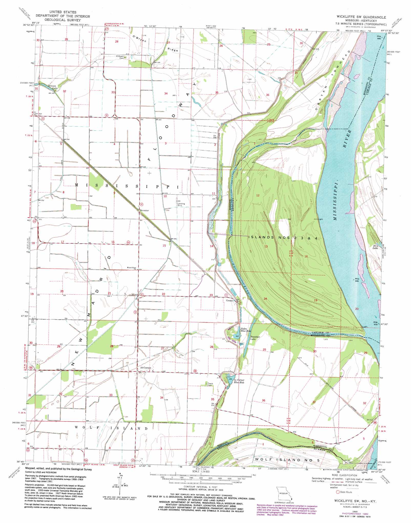
USGS Topo Quad 36089g2 - 1:24,000 scale
| Topo Map Name: | Wickliffe Sw |
| USGS Topo Quad ID: | 36089g2 |
| Print Size: | ca. 21 1/4" wide x 27" high |
| Southeast Coordinates: | 36.75° N latitude / 89.125° W longitude |
| Map Center Coordinates: | 36.8125° N latitude / 89.1875° W longitude |
| U.S. States: | MO, KY |
| Filename: | o36089g2.jpg |
| Download Map JPG Image: | Wickliffe Sw topo map 1:24,000 scale |
| Map Type: | Topographic |
| Topo Series: | 7.5´ |
| Map Scale: | 1:24,000 |
| Source of Map Images: | United States Geological Survey (USGS) |
| Alternate Map Versions: |
Wickliffe SW MO 1951, updated 1953 Download PDF Buy paper map Wickliffe SW MO 1951, updated 1964 Download PDF Buy paper map Wickliffe SW MO 1969, updated 1972 Download PDF Buy paper map Wickliffe SW MO 1969, updated 1983 Download PDF Buy paper map Wickliffe SW MO 2010 Download PDF Buy paper map Wickliffe SW MO 2012 Download PDF Buy paper map Wickliffe SW MO 2015 Download PDF Buy paper map |
1:24,000 Topo Quads surrounding Wickliffe Sw
Thebes Sw |
Cache |
Cairo |
Barlow |
La Center |
Bertrand |
Charleston |
Wyatt |
Wickliffe |
Blandville |
East Prairie |
Anniston |
Wickliffe Sw |
Arlington |
Milburn |
Henderson Mound |
Bayouville |
Wolf Island |
Oakton |
Clinton |
Hubbard Lake |
Bondurant |
Hickman |
Cayce |
Crutchfield |
> Back to 36089e1 at 1:100,000 scale
> Back to 36088a1 at 1:250,000 scale
> Back to U.S. Topo Maps home
Wickliffe Sw topo map: Gazetteer
Wickliffe Sw: Areas
New Madrid Floodway elevation 92m 301′Wickliffe Sw: Bends
Lucas Bend elevation 92m 301′Wickliffe Sw: Canals
Glory Bayou elevation 95m 311′Lateral Number 1 (historical) elevation 92m 301′
Lateral Number 3 elevation 94m 308′
Wickliffe Sw: Islands
Islands Nos 2 3 and 4 elevation 94m 308′O'Bryan Towhead elevation 95m 311′
Wickliffe Sw: Lakes
Barnell Lake (historical) elevation 93m 305′Bratcher Lake elevation 95m 311′
Nolen Blue Hole elevation 93m 305′
Thirtyfour Corner Blue Hole elevation 91m 298′
Wickliffe Sw: Populated Places
Crosno elevation 95m 311′Deventer elevation 93m 305′
Fuget elevation 94m 308′
Thirtyfour Corner elevation 92m 301′
Wickliffe Sw: Ridges
O'Bryan Ridge elevation 96m 314′Wickliffe Sw: Streams
Number 3 Chute elevation 88m 288′Wickliffe Sw digital topo map on disk
Buy this Wickliffe Sw topo map showing relief, roads, GPS coordinates and other geographical features, as a high-resolution digital map file on DVD: