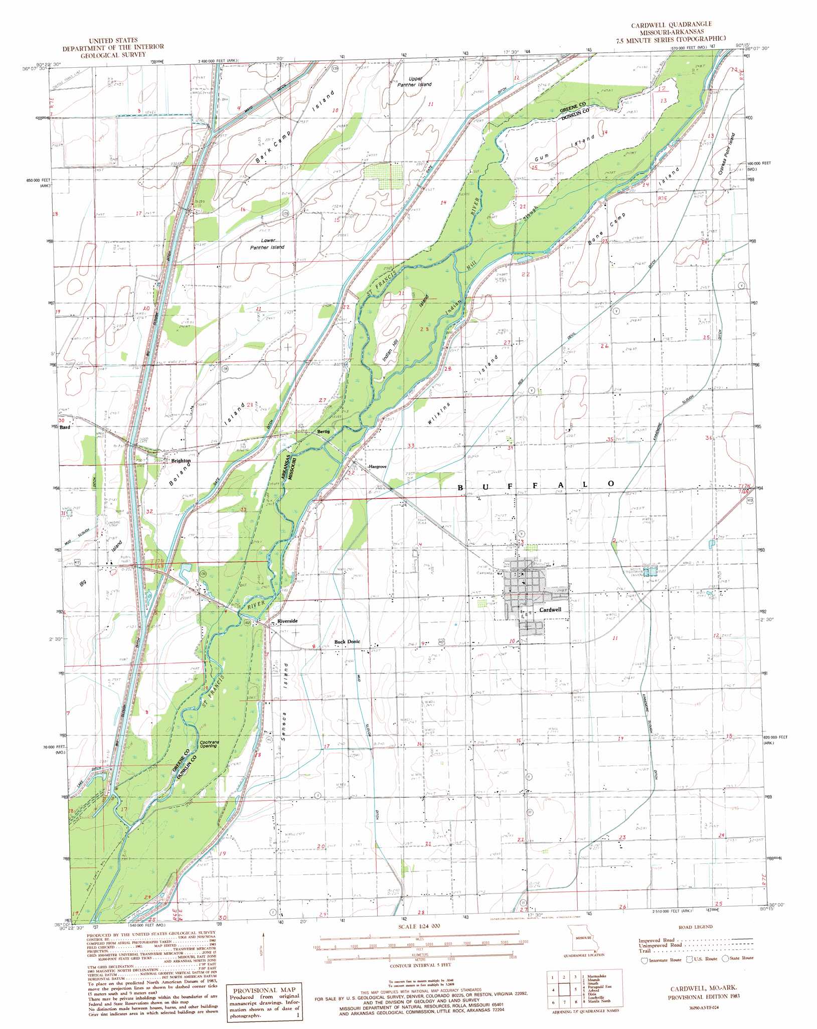
Cardwell Topo Map Missouri
To zoom in, hover over the map of Cardwell
USGS Topo Quad 36090a3 - 1:24,000 scale
| Topo Map Name: | Cardwell |
| USGS Topo Quad ID: | 36090a3 |
| Print Size: | ca. 21 1/4" wide x 27" high |
| Southeast Coordinates: | 36° N latitude / 90.25° W longitude |
| Map Center Coordinates: | 36.0625° N latitude / 90.3125° W longitude |
| U.S. States: | MO, AR |
| Filename: | o36090a3.jpg |
| Download Map JPG Image: | Cardwell topo map 1:24,000 scale |
| Map Type: | Topographic |
| Topo Series: | 7.5´ |
| Map Scale: | 1:24,000 |
| Source of Map Images: | United States Geological Survey (USGS) |
| Alternate Map Versions: |
Cardwell MO 1983, updated 1984 Download PDF Buy paper map Cardwell MO 2011 Download PDF Buy paper map Cardwell MO 2011 Download PDF Buy paper map Cardwell MO 2015 Download PDF Buy paper map |
1:24,000 Topo Quads surrounding Cardwell
Knobel |
Boydsville |
Rector |
Greenway |
Kennett North |
Lafe |
Marmaduke |
Mounds |
Senath |
Kennett South |
Paragould West |
Paragould East |
Cardwell |
Arbyrd |
Hornersville |
Brookland |
Dixie |
Leachville |
Manila North |
Half Moon |
Needham |
Lake City |
Caraway |
Manila South |
Dell |
> Back to 36090a1 at 1:100,000 scale
> Back to 36090a1 at 1:250,000 scale
> Back to U.S. Topo Maps home
Cardwell topo map: Gazetteer
Cardwell: Airports
Quinn Field elevation 72m 236′Cardwell: Areas
Bone Camp Island elevation 76m 249′Seneca Island elevation 75m 246′
Wilkins Island elevation 75m 246′
Cardwell: Bridges
Hopkins Bridge elevation 75m 246′Hopkins Bridge elevation 79m 259′
Cardwell: Canals
Lake Ditch elevation 71m 232′Lateral Number 2 elevation 73m 239′
Lateral Number 3 elevation 73m 239′
Missouri Ditch Number 4 elevation 72m 236′
Mud Slough Ditch elevation 70m 229′
Red Devil Ditch elevation 73m 239′
Cardwell: Islands
Bark Camp Island elevation 73m 239′Big Island elevation 73m 239′
Boland Island elevation 72m 236′
Gum Island elevation 76m 249′
Indian Hill Island elevation 76m 249′
Lower Panther Island elevation 71m 232′
Upper Panther Island elevation 75m 246′
Cardwell: Populated Places
Bertig elevation 74m 242′Brighton elevation 72m 236′
Buck Donic elevation 73m 239′
Cardwell elevation 75m 246′
Cockrum elevation 75m 246′
Hargrove elevation 75m 246′
Riverside elevation 76m 249′
Cardwell: Streams
Indian Hill Slough elevation 73m 239′Seneca Slough elevation 73m 239′
Cardwell: Swamps
Cochrans Opening elevation 73m 239′Cardwell digital topo map on disk
Buy this Cardwell topo map showing relief, roads, GPS coordinates and other geographical features, as a high-resolution digital map file on DVD: