Kennett South Topo Map Missouri
To zoom in, hover over the map of Kennett South
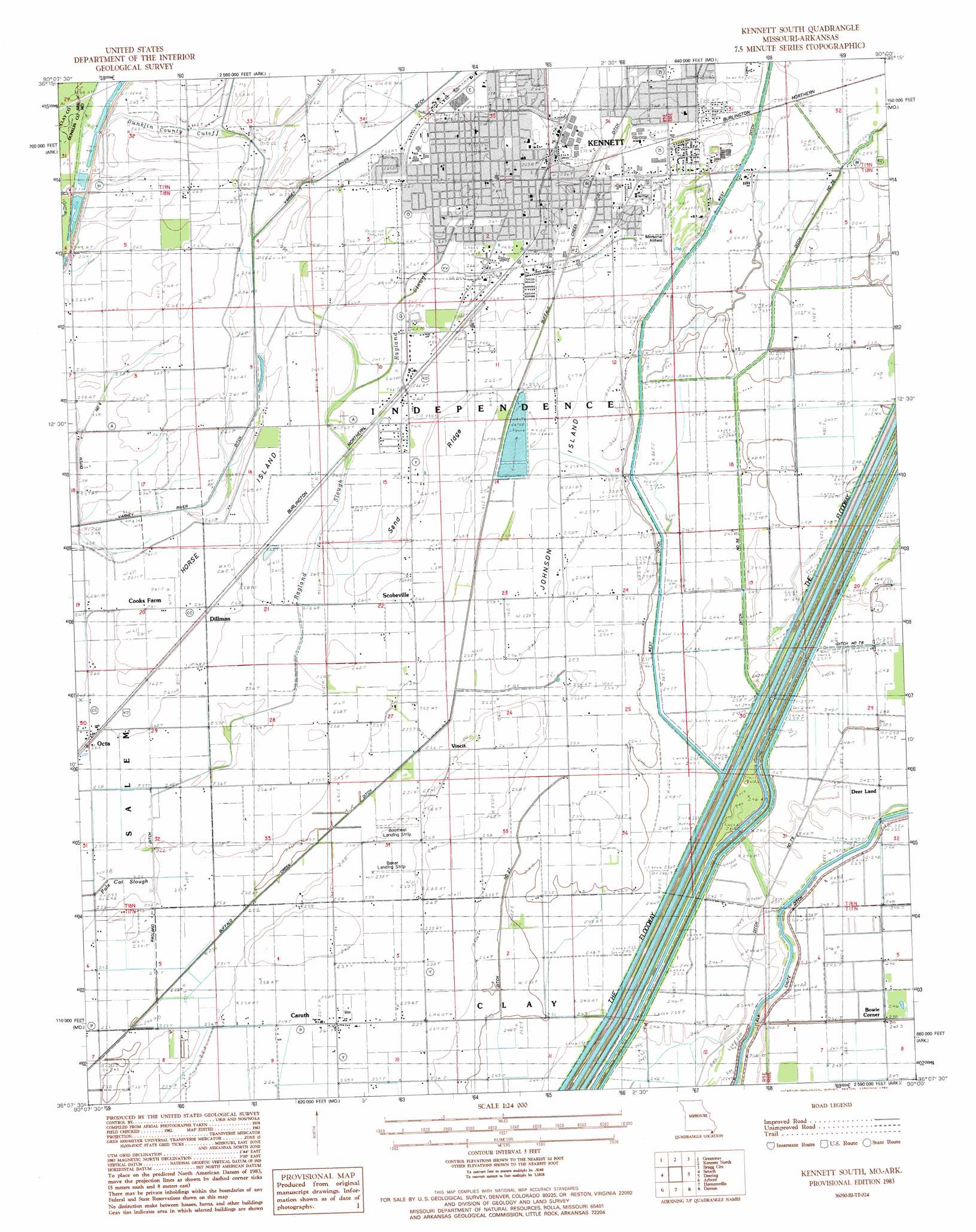
USGS Topo Quad 36090b1 - 1:24,000 scale
| Topo Map Name: | Kennett South |
| USGS Topo Quad ID: | 36090b1 |
| Print Size: | ca. 21 1/4" wide x 27" high |
| Southeast Coordinates: | 36.125° N latitude / 90° W longitude |
| Map Center Coordinates: | 36.1875° N latitude / 90.0625° W longitude |
| U.S. States: | MO, AR |
| Filename: | o36090b1.jpg |
| Download Map JPG Image: | Kennett South topo map 1:24,000 scale |
| Map Type: | Topographic |
| Topo Series: | 7.5´ |
| Map Scale: | 1:24,000 |
| Source of Map Images: | United States Geological Survey (USGS) |
| Alternate Map Versions: |
Kennett South MO 1983, updated 1984 Download PDF Buy paper map Kennett South MO 2011 Download PDF Buy paper map Kennett South MO 2011 Download PDF Buy paper map Kennett South MO 2015 Download PDF Buy paper map |
1:24,000 Topo Quads surrounding Kennett South
Pollard |
Peggott |
Campbell |
Gideon |
Boekerton |
Rector |
Greenway |
Kennett North |
Bragg City |
Wardell |
Mounds |
Senath |
Kennett South |
Deering |
Hayti Heights |
Cardwell |
Arbyrd |
Hornersville |
Denton |
Steele |
Leachville |
Manila North |
Half Moon |
Blytheville |
Armorel |
> Back to 36090a1 at 1:100,000 scale
> Back to 36090a1 at 1:250,000 scale
> Back to U.S. Topo Maps home
Kennett South topo map: Gazetteer
Kennett South: Airports
Baker Landing Strip elevation 79m 259′Bootheel Landing Strip elevation 78m 255′
Kennett Memorial Airfield elevation 80m 262′
Twin Rivers Regional Medical Center Heliport elevation 82m 269′
Kennett South: Canals
Ditch Number 19 elevation 76m 249′Ditch Number 259 elevation 74m 242′
Ditch Number 27 elevation 76m 249′
Ditch Number 3 elevation 81m 265′
Ditch Number 36 elevation 74m 242′
Ditch Number 4 elevation 79m 259′
Ditch Number 66 elevation 74m 242′
Ditch Number 79 elevation 74m 242′
Ditch Number 81 elevation 73m 239′
Dunklin County Cut-off elevation 79m 259′
Lateral Number 1 elevation 75m 246′
Lateral Number 2 elevation 75m 246′
Lateral Number 3 elevation 76m 249′
Lateral Number 4 elevation 77m 252′
Main Ditch Number 10 elevation 80m 262′
Ragland Ditch elevation 78m 255′
Varney River Canal elevation 80m 262′
Kennett South: Islands
Horse Island elevation 80m 262′Johnson Island elevation 77m 252′
Kennett South: Lakes
Swan Hole elevation 79m 259′Kennett South: Populated Places
Bowie Corner elevation 75m 246′Caruth elevation 79m 259′
Deer Land elevation 76m 249′
Dillman elevation 79m 259′
Kennett elevation 82m 269′
Octa elevation 79m 259′
Scobeville elevation 80m 262′
Vincit elevation 77m 252′
Kennett South: Ridges
Sand Ridge elevation 79m 259′Kennett South: Streams
Ragland Slough elevation 76m 249′Snipe Slough elevation 80m 262′
Kennett South digital topo map on disk
Buy this Kennett South topo map showing relief, roads, GPS coordinates and other geographical features, as a high-resolution digital map file on DVD: