Hanleyville Topo Map Missouri
To zoom in, hover over the map of Hanleyville
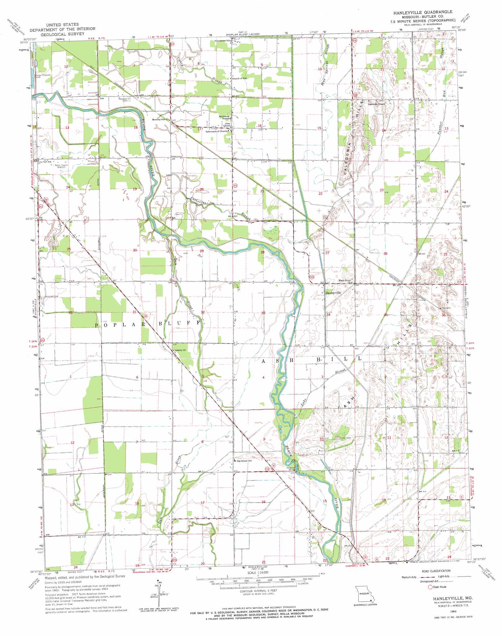
USGS Topo Quad 36090f3 - 1:24,000 scale
| Topo Map Name: | Hanleyville |
| USGS Topo Quad ID: | 36090f3 |
| Print Size: | ca. 21 1/4" wide x 27" high |
| Southeast Coordinates: | 36.625° N latitude / 90.25° W longitude |
| Map Center Coordinates: | 36.6875° N latitude / 90.3125° W longitude |
| U.S. State: | MO |
| Filename: | o36090f3.jpg |
| Download Map JPG Image: | Hanleyville topo map 1:24,000 scale |
| Map Type: | Topographic |
| Topo Series: | 7.5´ |
| Map Scale: | 1:24,000 |
| Source of Map Images: | United States Geological Survey (USGS) |
| Alternate Map Versions: |
Hanleyville MO 1963, updated 1965 Download PDF Buy paper map Hanleyville MO 2011 Download PDF Buy paper map Hanleyville MO 2015 Download PDF Buy paper map |
1:24,000 Topo Quads surrounding Hanleyville
Williamsville |
Hendrickson |
Wappapello |
Puxico |
Acorn Ridge |
Stringtown |
Poplar Bluff |
Rombauer |
Fisk |
Dudley |
Fairdealing |
Harviell |
Hanleyville |
Broseley |
Powe |
Naylor |
Vastus |
Oglesville |
Glennonville |
Valley Ridge |
Corning |
Mcdougal |
Pollard |
Peggott |
Campbell |
> Back to 36090e1 at 1:100,000 scale
> Back to 36090a1 at 1:250,000 scale
> Back to U.S. Topo Maps home
Hanleyville topo map: Gazetteer
Hanleyville: Airports
Hayes Field elevation 98m 321′Hanleyville: Bars
Jackson Bar elevation 100m 328′Hanleyville: Bends
Buttermilk Bend elevation 94m 308′Deadmans Bend elevation 94m 308′
Grape Vine Bend elevation 96m 314′
Hammons Bend elevation 97m 318′
Hanleyville: Bridges
Hargove Bridge elevation 96m 314′Hanleyville: Canals
Ackerman Ditch elevation 93m 305′Ditch Number 14 elevation 96m 314′
Hanleyville: Flats
Doolens Pasture elevation 96m 314′Hanleyville: Guts
Caney Slough elevation 98m 321′Panther Run Slough elevation 97m 318′
Hanleyville: Islands
Big Island elevation 96m 314′Hanleyville: Populated Places
Hanleyville elevation 95m 311′Mayberry elevation 100m 328′
Morocco elevation 100m 328′
Hanleyville: Ranges
Ash Hills elevation 97m 318′Caledonia Hills elevation 99m 324′
Hanleyville: Rapids
Hoggs Eddy elevation 96m 314′Marshall Eddy elevation 95m 311′
Hanleyville: Streams
Blue Spring Slough elevation 96m 314′Catherine Slough elevation 97m 318′
Cross Slough elevation 95m 311′
Lake Slough elevation 94m 308′
Hanleyville digital topo map on disk
Buy this Hanleyville topo map showing relief, roads, GPS coordinates and other geographical features, as a high-resolution digital map file on DVD: