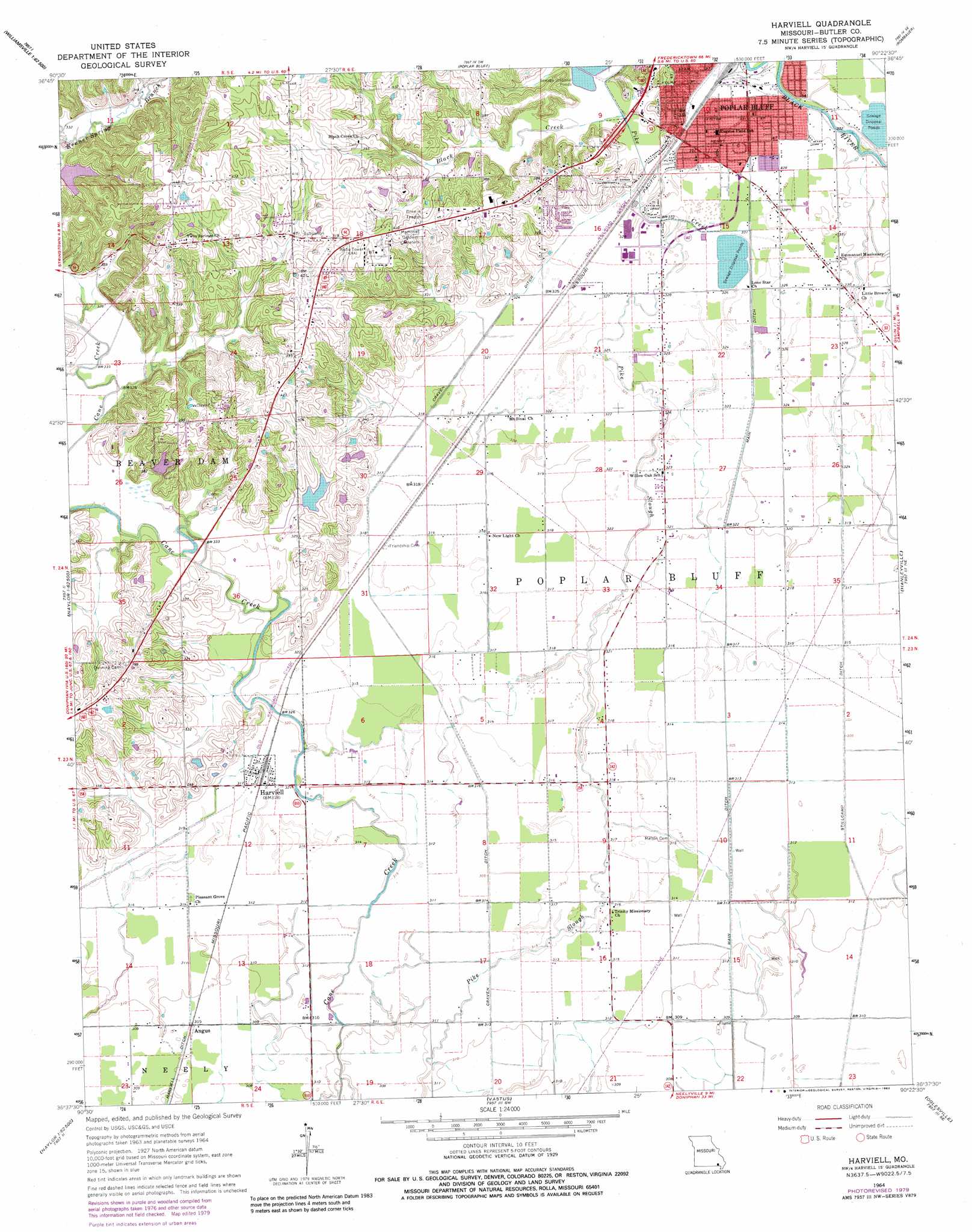
Harviell Topo Map Missouri
To zoom in, hover over the map of Harviell
USGS Topo Quad 36090f4 - 1:24,000 scale
| Topo Map Name: | Harviell |
| USGS Topo Quad ID: | 36090f4 |
| Print Size: | ca. 21 1/4" wide x 27" high |
| Southeast Coordinates: | 36.625° N latitude / 90.375° W longitude |
| Map Center Coordinates: | 36.6875° N latitude / 90.4375° W longitude |
| U.S. State: | MO |
| Filename: | o36090f4.jpg |
| Download Map JPG Image: | Harviell topo map 1:24,000 scale |
| Map Type: | Topographic |
| Topo Series: | 7.5´ |
| Map Scale: | 1:24,000 |
| Source of Map Images: | United States Geological Survey (USGS) |
| Alternate Map Versions: |
Harviell MO 1964, updated 1965 Download PDF Buy paper map Harviell MO 1964, updated 1979 Download PDF Buy paper map Harviell MO 1964, updated 1983 Download PDF Buy paper map Harviell MO 2011 Download PDF Buy paper map Harviell MO 2015 Download PDF Buy paper map |
1:24,000 Topo Quads surrounding Harviell
Ellsinore |
Williamsville |
Hendrickson |
Wappapello |
Puxico |
Hogan Hollow |
Stringtown |
Poplar Bluff |
Rombauer |
Fisk |
Flatwoods |
Fairdealing |
Harviell |
Hanleyville |
Broseley |
Oxly |
Naylor |
Vastus |
Oglesville |
Glennonville |
Datto |
Corning |
Mcdougal |
Pollard |
Peggott |
> Back to 36090e1 at 1:100,000 scale
> Back to 36090a1 at 1:250,000 scale
> Back to U.S. Topo Maps home
Harviell topo map: Gazetteer
Harviell: Bends
Freemans Bend elevation 100m 328′Harviell: Canals
Craven Ditch elevation 95m 311′Craven Ditch elevation 99m 324′
Harviell Ditch elevation 94m 308′
Main Ditch elevation 92m 301′
Harviell: Dams
Lake Christene Dam elevation 107m 351′Resniks Lake Dam elevation 102m 334′
Harviell: Populated Places
Angus elevation 95m 311′Ashcroft Addition elevation 100m 328′
Harviell elevation 97m 318′
Vinegar Hill elevation 102m 334′
Harviell: Reservoirs
Lake Christene elevation 107m 351′Resniks Lake elevation 102m 334′
Harviell: Streams
Black Creek elevation 99m 324′Pike Creek elevation 99m 324′
Pike Slough elevation 93m 305′
Harviell digital topo map on disk
Buy this Harviell topo map showing relief, roads, GPS coordinates and other geographical features, as a high-resolution digital map file on DVD: