Hogan Hollow Topo Map Missouri
To zoom in, hover over the map of Hogan Hollow
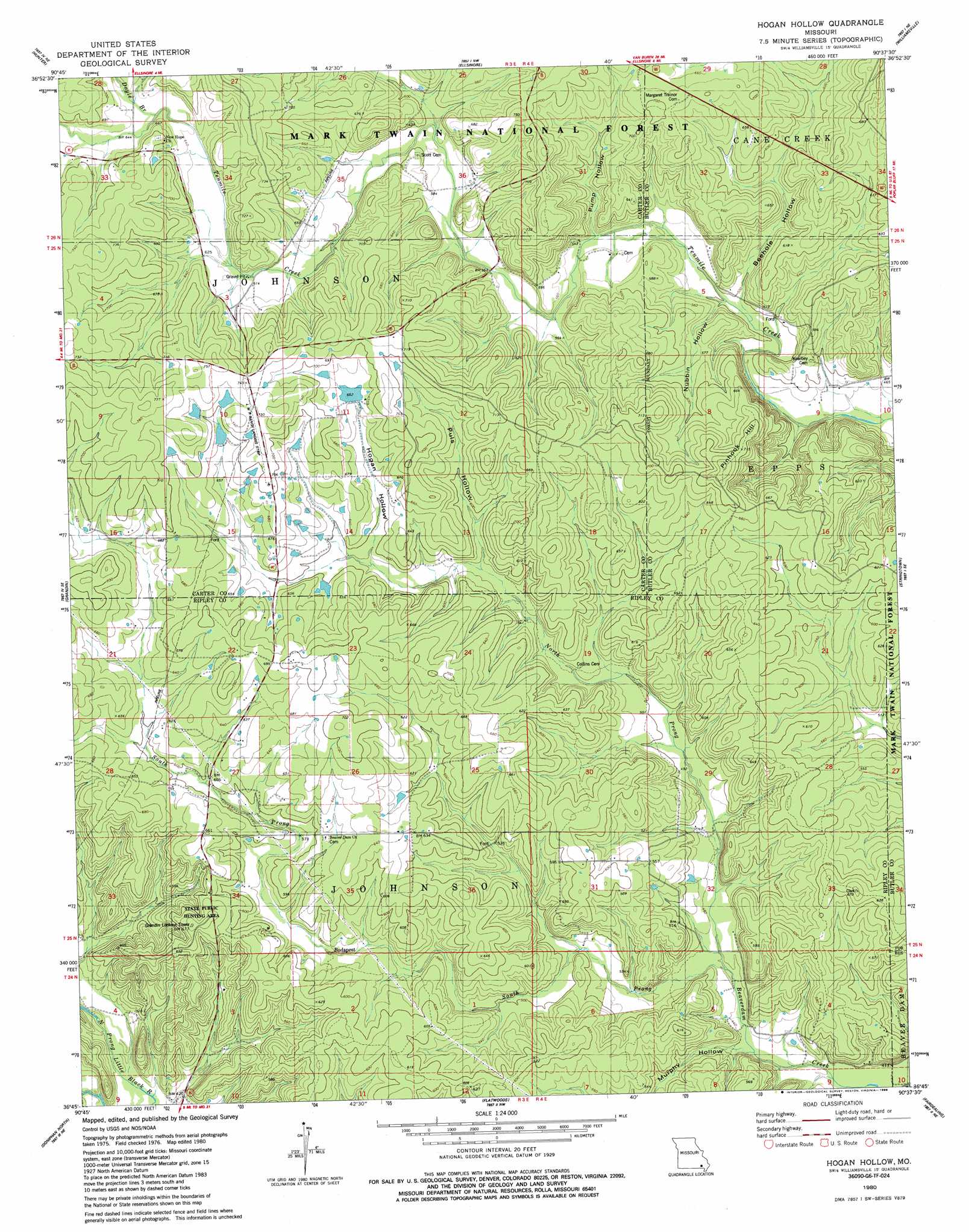
USGS Topo Quad 36090g6 - 1:24,000 scale
| Topo Map Name: | Hogan Hollow |
| USGS Topo Quad ID: | 36090g6 |
| Print Size: | ca. 21 1/4" wide x 27" high |
| Southeast Coordinates: | 36.75° N latitude / 90.625° W longitude |
| Map Center Coordinates: | 36.8125° N latitude / 90.6875° W longitude |
| U.S. State: | MO |
| Filename: | o36090g6.jpg |
| Download Map JPG Image: | Hogan Hollow topo map 1:24,000 scale |
| Map Type: | Topographic |
| Topo Series: | 7.5´ |
| Map Scale: | 1:24,000 |
| Source of Map Images: | United States Geological Survey (USGS) |
| Alternate Map Versions: |
Hogan Hollow MO 1980, updated 1980 Download PDF Buy paper map Hogan Hollow MO 1980, updated 1986 Download PDF Buy paper map Hogan Hollow MO 2011 Download PDF Buy paper map Hogan Hollow MO 2015 Download PDF Buy paper map |
| FStopo: | US Forest Service topo Hogan Hollow is available: Download FStopo PDF Download FStopo TIF |
1:24,000 Topo Quads surrounding Hogan Hollow
Garwood |
Ellington Se |
Mill Spring |
Piedmont Se |
Greenville Sw |
Big Spring |
Hunter |
Ellsinore |
Williamsville |
Hendrickson |
Grandin Sw |
Grandin |
Hogan Hollow |
Stringtown |
Poplar Bluff |
Briar |
Doniphan North |
Flatwoods |
Fairdealing |
Harviell |
Poynor |
Doniphan South |
Oxly |
Naylor |
Vastus |
> Back to 36090e1 at 1:100,000 scale
> Back to 36090a1 at 1:250,000 scale
> Back to U.S. Topo Maps home
Hogan Hollow topo map: Gazetteer
Hogan Hollow: Airports
L W R Ranch Landing Strip elevation 220m 721′Mb Ranch Airport elevation 225m 738′
Hogan Hollow: Dams
Beaver Lake Dam elevation 178m 583′Lake Hogan Dam elevation 203m 666′
Mallard Lake Dam elevation 193m 633′
Hogan Hollow: Parks
State Public Hunting Area elevation 201m 659′Hogan Hollow: Populated Places
Beaverdam elevation 128m 419′Budapest elevation 170m 557′
Homestead (historical) elevation 206m 675′
Hogan Hollow: Reservoirs
Beaver Lake elevation 178m 583′Lake Hogan elevation 203m 666′
Mallard Dam elevation 193m 633′
Hogan Hollow: Streams
Beehole Branch elevation 151m 495′Doyle Branch elevation 195m 639′
North Prong Beaverdam Creek elevation 134m 439′
South Prong Beaverdam Creek elevation 134m 439′
Hogan Hollow: Summits
Pinhook Hill elevation 229m 751′Hogan Hollow: Valleys
Beehole Hollow elevation 151m 495′Hogan Hollow elevation 180m 590′
Murphy Hollow elevation 131m 429′
Nubbin Hollow elevation 165m 541′
Puls Hollow elevation 170m 557′
Pump Hollow elevation 164m 538′
Hogan Hollow digital topo map on disk
Buy this Hogan Hollow topo map showing relief, roads, GPS coordinates and other geographical features, as a high-resolution digital map file on DVD: