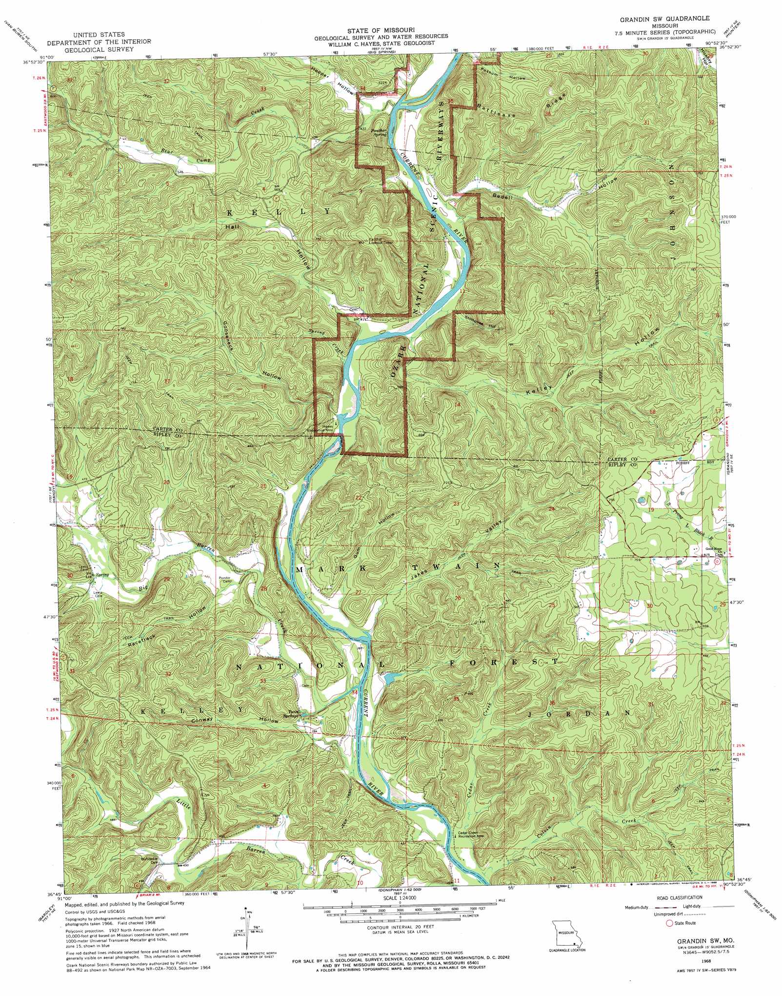
Grandin Sw Topo Map Missouri
To zoom in, hover over the map of Grandin Sw
USGS Topo Quad 36090g8 - 1:24,000 scale
| Topo Map Name: | Grandin Sw |
| USGS Topo Quad ID: | 36090g8 |
| Print Size: | ca. 21 1/4" wide x 27" high |
| Southeast Coordinates: | 36.75° N latitude / 90.875° W longitude |
| Map Center Coordinates: | 36.8125° N latitude / 90.9375° W longitude |
| U.S. State: | MO |
| Filename: | o36090g8.jpg |
| Download Map JPG Image: | Grandin Sw topo map 1:24,000 scale |
| Map Type: | Topographic |
| Topo Series: | 7.5´ |
| Map Scale: | 1:24,000 |
| Source of Map Images: | United States Geological Survey (USGS) |
| Alternate Map Versions: |
Grandin SW MO 1968, updated 1969 Download PDF Buy paper map Grandin SW MO 1968, updated 1970 Download PDF Buy paper map Grandin SW MO 1997, updated 2000 Download PDF Buy paper map Grandin SW MO 2011 Download PDF Buy paper map Grandin SW MO 2015 Download PDF Buy paper map |
| FStopo: | US Forest Service topo Grandin SW is available: Download FStopo PDF Download FStopo TIF |
1:24,000 Topo Quads surrounding Grandin Sw
Stegall Mountain |
Van Buren North |
Garwood |
Ellington Se |
Mill Spring |
Fremont |
Van Buren South |
Big Spring |
Hunter |
Ellsinore |
Wilderness |
Handy |
Grandin Sw |
Grandin |
Hogan Hollow |
Riverton |
Bardley |
Briar |
Doniphan North |
Flatwoods |
Billmore |
Gatewood |
Poynor |
Doniphan South |
Oxly |
> Back to 36090e1 at 1:100,000 scale
> Back to 36090a1 at 1:250,000 scale
> Back to U.S. Topo Maps home
Grandin Sw topo map: Gazetteer
Grandin Sw: Bays
Bay Nothing (historical) elevation 117m 383′Colvin Bay (historical) elevation 111m 364′
Gun Bay (historical) elevation 123m 403′
Jakes Bay elevation 116m 380′
Kelly Bay elevation 122m 400′
Mayberry Bay elevation 116m 380′
Phillips Bay elevation 119m 390′
Tucker Bay elevation 115m 377′
Grandin Sw: Cliffs
Kelley Bluff elevation 138m 452′Tunnel Bluff elevation 142m 465′
Grandin Sw: Dams
Marlboro Dam elevation 125m 410′Grandin Sw: Populated Places
Tucker elevation 115m 377′Grandin Sw: Reservoirs
Marlboro Lake elevation 125m 410′Grandin Sw: Ridges
Battleaxe Ridge elevation 228m 748′Grandin Sw: Springs
Panther Spring elevation 122m 400′Twin Springs elevation 117m 383′
Grandin Sw: Streams
Bear Camp Creek elevation 122m 400′Big Barren Creek elevation 116m 380′
Cedar Creek elevation 118m 387′
Colvin Creek elevation 114m 374′
Spring Creek elevation 119m 390′
Grandin Sw: Swamps
Kelley Bay elevation 122m 400′Grandin Sw: Valleys
Bedell Hollow elevation 122m 400′Conway Hollow elevation 116m 380′
Gooseneck Hollow elevation 122m 400′
Gum Hollow elevation 118m 387′
Hall Hollow elevation 122m 400′
Hooper Hollow elevation 125m 410′
Jakes Valley elevation 116m 380′
Kelley Hollow elevation 122m 400′
Racetrack Hollow elevation 128m 419′
Stillhouse Hollow elevation 123m 403′
Grandin Sw digital topo map on disk
Buy this Grandin Sw topo map showing relief, roads, GPS coordinates and other geographical features, as a high-resolution digital map file on DVD: