Smithville Topo Map Arkansas
To zoom in, hover over the map of Smithville
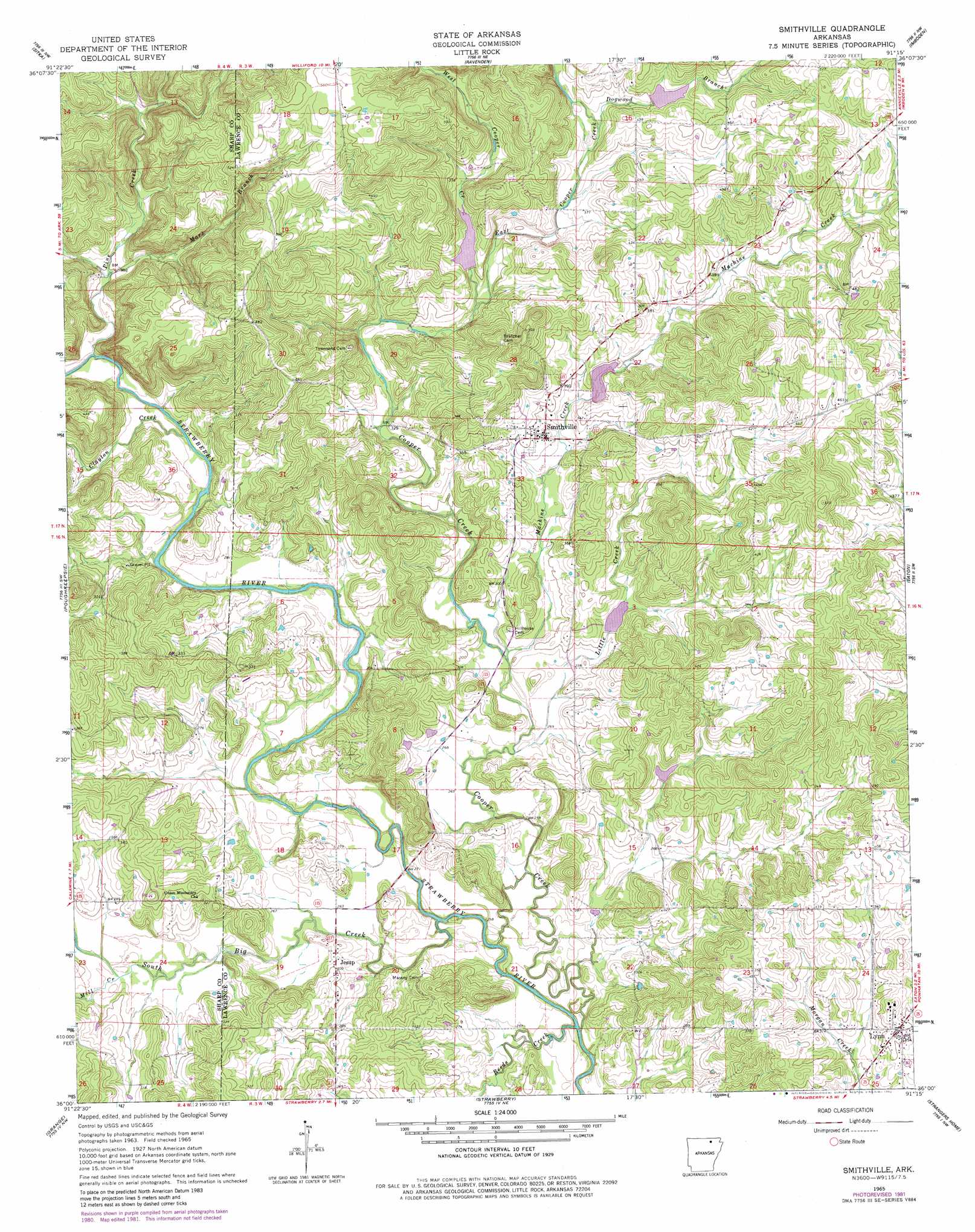
USGS Topo Quad 36091a3 - 1:24,000 scale
| Topo Map Name: | Smithville |
| USGS Topo Quad ID: | 36091a3 |
| Print Size: | ca. 21 1/4" wide x 27" high |
| Southeast Coordinates: | 36° N latitude / 91.25° W longitude |
| Map Center Coordinates: | 36.0625° N latitude / 91.3125° W longitude |
| U.S. State: | AR |
| Filename: | o36091a3.jpg |
| Download Map JPG Image: | Smithville topo map 1:24,000 scale |
| Map Type: | Topographic |
| Topo Series: | 7.5´ |
| Map Scale: | 1:24,000 |
| Source of Map Images: | United States Geological Survey (USGS) |
| Alternate Map Versions: |
Smithville AR 1965, updated 1966 Download PDF Buy paper map Smithville AR 1965, updated 1980 Download PDF Buy paper map Smithville AR 1965, updated 1982 Download PDF Buy paper map Smithville AR 2011 Download PDF Buy paper map Smithville AR 2014 Download PDF Buy paper map |
1:24,000 Topo Quads surrounding Smithville
Stuart |
Hardy |
Williford |
Ravenden Springs |
Ravenden Springs Se |
Ash Flat |
Sitka |
Ravenden |
Imboden |
Noland |
Evening Shade |
Poughkeepsie |
Smithville |
Eaton |
Black Rock |
Cave City |
Grange |
Strawberry |
Strangers Home |
Alicia |
Sulphur Rock |
Charlotte |
Cord |
Swifton West |
Swifton East |
> Back to 36091a1 at 1:100,000 scale
> Back to 36090a1 at 1:250,000 scale
> Back to U.S. Topo Maps home
Smithville topo map: Gazetteer
Smithville: Dams
Cooper Creek Site Five Dam elevation 105m 344′Cooper Creek Site Four Dam elevation 108m 354′
Cooper Creek Site One Dam elevation 110m 360′
Cooper Creek Site Six Dam elevation 95m 311′
Cooper Creek Site Three Dam elevation 127m 416′
Smithville: Populated Places
Jesup elevation 86m 282′Lynn elevation 106m 347′
Smithville elevation 104m 341′
Smithville: Reservoirs
Cooper Creek Site Five Reservoir elevation 105m 344′Cooper Creek Site Four Reservoir elevation 108m 354′
Cooper Creek Site One Reservoir elevation 110m 360′
Cooper Creek Site Six Reservoir elevation 95m 311′
Cooper Creek Site Three Reservoir elevation 127m 416′
Smithville: Streams
Clayton Creek elevation 81m 265′Cooper Creek elevation 73m 239′
Dogwood Branch elevation 113m 370′
East Cooper Creek elevation 99m 324′
Little Creek elevation 80m 262′
Machine Creek elevation 82m 269′
Mars Branch elevation 90m 295′
Mill Creek elevation 81m 265′
Pine Creek elevation 81m 265′
Reeds Creek elevation 70m 229′
South Big Creek elevation 75m 246′
West Cooper Creek elevation 99m 324′
Smithville digital topo map on disk
Buy this Smithville topo map showing relief, roads, GPS coordinates and other geographical features, as a high-resolution digital map file on DVD: