Stuart Topo Map Arkansas
To zoom in, hover over the map of Stuart
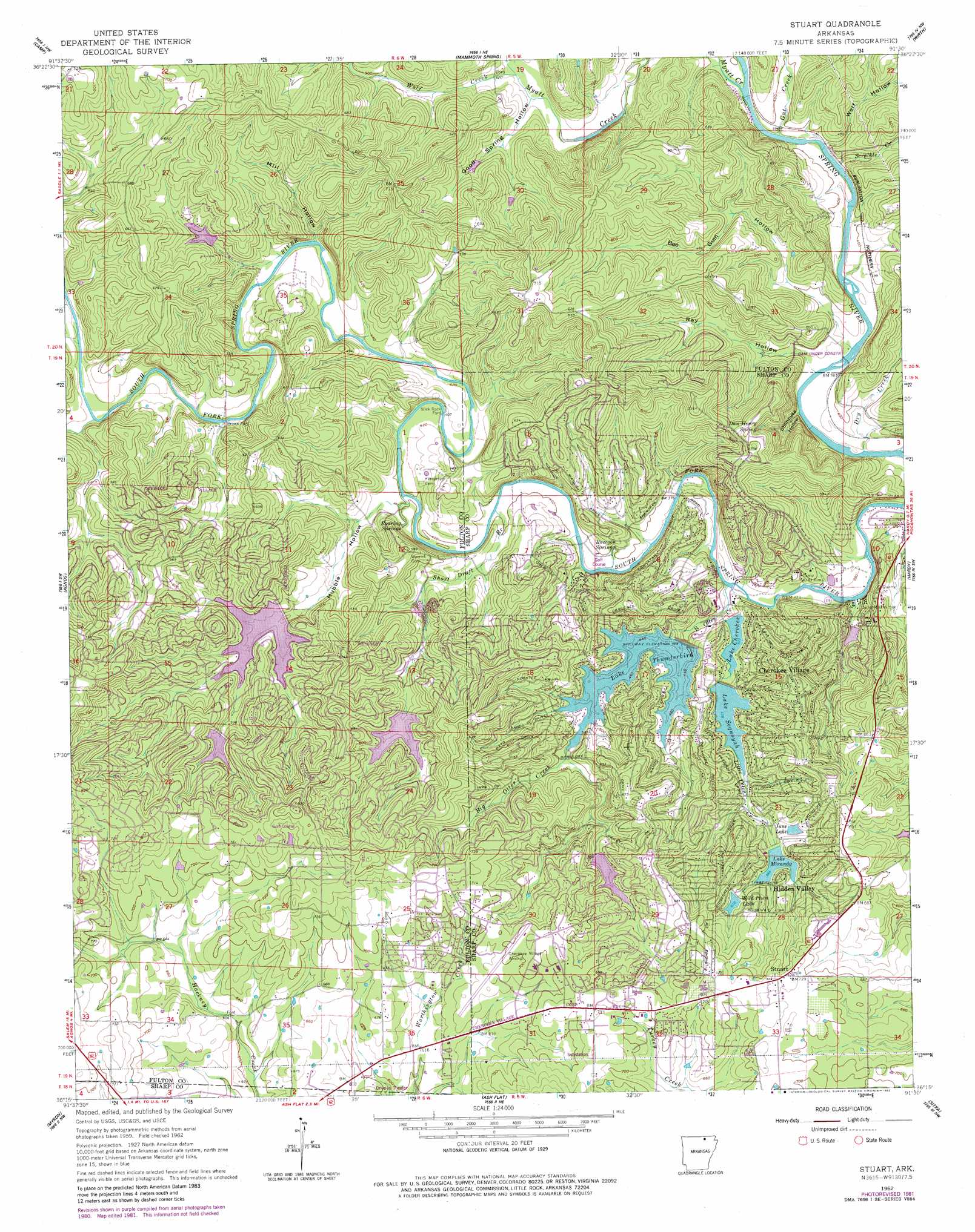
USGS Topo Quad 36091c5 - 1:24,000 scale
| Topo Map Name: | Stuart |
| USGS Topo Quad ID: | 36091c5 |
| Print Size: | ca. 21 1/4" wide x 27" high |
| Southeast Coordinates: | 36.25° N latitude / 91.5° W longitude |
| Map Center Coordinates: | 36.3125° N latitude / 91.5625° W longitude |
| U.S. State: | AR |
| Filename: | o36091c5.jpg |
| Download Map JPG Image: | Stuart topo map 1:24,000 scale |
| Map Type: | Topographic |
| Topo Series: | 7.5´ |
| Map Scale: | 1:24,000 |
| Source of Map Images: | United States Geological Survey (USGS) |
| Alternate Map Versions: |
Stuart AR 1962, updated 1963 Download PDF Buy paper map Stuart AR 1962, updated 1975 Download PDF Buy paper map Stuart AR 1962, updated 1982 Download PDF Buy paper map Stuart AR 1962, updated 1982 Download PDF Buy paper map Stuart AR 2011 Download PDF Buy paper map Stuart AR 2014 Download PDF Buy paper map |
1:24,000 Topo Quads surrounding Stuart
Lanton |
Koshkonong |
Thayer |
Conch |
Myrtle |
Salem Knob |
Camp |
Mammoth Spring |
Wirth |
Hardy Ne |
Salem |
Agnos |
Stuart |
Hardy |
Williford |
Franklin |
Myron |
Ash Flat |
Sitka |
Ravenden |
Zion |
Sidney |
Evening Shade |
Poughkeepsie |
Smithville |
> Back to 36091a1 at 1:100,000 scale
> Back to 36090a1 at 1:250,000 scale
> Back to U.S. Topo Maps home
Stuart topo map: Gazetteer
Stuart: Airports
Cherokee Village Airport elevation 205m 672′Cherokee Village Heliport elevation 220m 721′
Stuart: Crossings
Brown Ford elevation 133m 436′Stuart: Dams
Camp Kia Kima Lake Dam elevation 163m 534′Lake Aztec Dam elevation 186m 610′
Lake Chanute Dam elevation 171m 561′
Lake Cherokee Dam elevation 116m 380′
Lake Galilee Dam elevation 134m 439′
Lake June Dam elevation 169m 554′
Lake Mirandy Dam elevation 173m 567′
Lake Navajo Dam elevation 189m 620′
Lake Omaha Dam elevation 142m 465′
Lake Sequoyah Dam elevation 143m 469′
Lake Thunderbird Dam elevation 129m 423′
Wild Plum Lake Dam elevation 184m 603′
Stuart: Populated Places
Cherokee Village elevation 195m 639′Draft (historical) elevation 167m 547′
Hidden Valley elevation 207m 679′
Highland elevation 186m 610′
Stuart elevation 222m 728′
Stuart: Reservoirs
Camp Kia Kima Lake elevation 163m 534′June Lake elevation 169m 554′
Lake Aztec elevation 186m 610′
Lake Chanute elevation 171m 561′
Lake Cherokee elevation 116m 380′
Lake Galilee elevation 134m 439′
Lake Mirandy elevation 173m 567′
Lake Navajo elevation 189m 620′
Lake Omaha elevation 142m 465′
Lake Sequoyah elevation 143m 469′
Lake Thunderbird elevation 129m 423′
Wild Plum Lake elevation 184m 603′
Stuart: Springs
Dan Henry Spring elevation 171m 561′Raccoon Spring elevation 118m 387′
Roaring Springs elevation 122m 400′
Stuart: Streams
Big Otter Creek elevation 109m 357′Dry Creek elevation 106m 347′
Gut Creek elevation 115m 377′
Little Otter Creek elevation 115m 377′
Myatt Creek elevation 117m 383′
Right Prong Otter Creek elevation 151m 495′
Scrabble Creek elevation 117m 383′
Short Draft Branch elevation 116m 380′
Wild Horse Creek elevation 138m 452′
Wolf Creek elevation 128m 419′
Stuart: Valleys
Bee Gum Hollow elevation 108m 354′Good Spring Hollow elevation 126m 413′
Hubble Hollow elevation 121m 396′
Mill Hollow elevation 134m 439′
Ray Hollow elevation 105m 344′
Stillhouse Hollow elevation 107m 351′
Wolf Hollow elevation 118m 387′
Stuart digital topo map on disk
Buy this Stuart topo map showing relief, roads, GPS coordinates and other geographical features, as a high-resolution digital map file on DVD: