Wirth Topo Map Arkansas
To zoom in, hover over the map of Wirth
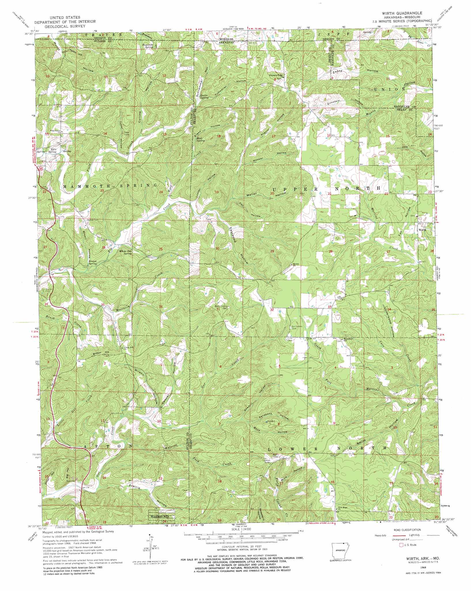
USGS Topo Quad 36091d4 - 1:24,000 scale
| Topo Map Name: | Wirth |
| USGS Topo Quad ID: | 36091d4 |
| Print Size: | ca. 21 1/4" wide x 27" high |
| Southeast Coordinates: | 36.375° N latitude / 91.375° W longitude |
| Map Center Coordinates: | 36.4375° N latitude / 91.4375° W longitude |
| U.S. States: | AR, MO |
| Filename: | o36091d4.jpg |
| Download Map JPG Image: | Wirth topo map 1:24,000 scale |
| Map Type: | Topographic |
| Topo Series: | 7.5´ |
| Map Scale: | 1:24,000 |
| Source of Map Images: | United States Geological Survey (USGS) |
| Alternate Map Versions: |
Wirth AR 1968, updated 1969 Download PDF Buy paper map Wirth AR 1968, updated 1981 Download PDF Buy paper map Wirth AR 2011 Download PDF Buy paper map Wirth AR 2014 Download PDF Buy paper map |
1:24,000 Topo Quads surrounding Wirth
Brandsville |
Rover |
Alton |
Many Springs |
Riverton |
Koshkonong |
Thayer |
Conch |
Myrtle |
Billmore |
Camp |
Mammoth Spring |
Wirth |
Hardy Ne |
Dalton |
Agnos |
Stuart |
Hardy |
Williford |
Ravenden Springs |
Myron |
Ash Flat |
Sitka |
Ravenden |
Imboden |
> Back to 36091a1 at 1:100,000 scale
> Back to 36090a1 at 1:250,000 scale
> Back to U.S. Topo Maps home
Wirth topo map: Gazetteer
Wirth: Populated Places
Wirth elevation 249m 816′Woodland Hills elevation 183m 600′
Wirth: Springs
Brown Spring elevation 156m 511′Davis Spring elevation 239m 784′
Ellis Spring elevation 170m 557′
Mud Spring elevation 207m 679′
Ruprecht Spring elevation 227m 744′
White Oak Spring elevation 168m 551′
Wirth: Streams
Cave Creek elevation 193m 633′Moccasin Creek elevation 149m 488′
Watered Fork Creek elevation 156m 511′
Wolf Creek elevation 168m 551′
Wirth: Summits
Britton Hill elevation 250m 820′Wirth: Valleys
Angotti Hollow elevation 215m 705′Big Hollow elevation 141m 462′
Bland Hollow elevation 199m 652′
Boyd Hollow elevation 204m 669′
Brown Hollow elevation 157m 515′
Conner Hollow elevation 173m 567′
Cullins Hollow elevation 215m 705′
Eastwood Hollow elevation 185m 606′
Fox Hollow elevation 225m 738′
Fox Hollow elevation 196m 643′
Hobbs Hollow elevation 178m 583′
Luster Hollow elevation 177m 580′
Mine Hollow elevation 213m 698′
Muntz Hollow elevation 174m 570′
Onion Hollow elevation 133m 436′
Prairie Hollow elevation 147m 482′
Ruprecht Hollow elevation 214m 702′
Sandbank Hollow elevation 206m 675′
Sawmill Hollow elevation 186m 610′
Schremmer Hollow elevation 237m 777′
Schremmer Hollow elevation 236m 774′
Smith Hollow elevation 200m 656′
Tober Hollow elevation 200m 656′
Tuttwaller Hollow elevation 233m 764′
Underwood Hollow elevation 206m 675′
Waller Hollow elevation 195m 639′
Webber Hollow elevation 204m 669′
Wilson Hollow elevation 169m 554′
Zentz Hollow elevation 212m 695′
Zirnstein Hollow elevation 230m 754′
Wirth digital topo map on disk
Buy this Wirth topo map showing relief, roads, GPS coordinates and other geographical features, as a high-resolution digital map file on DVD: