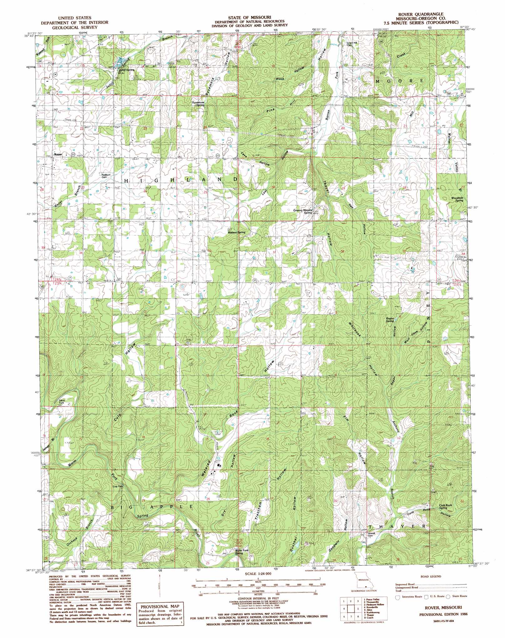
Rover Topo Map Missouri
To zoom in, hover over the map of Rover
USGS Topo Quad 36091f5 - 1:24,000 scale
| Topo Map Name: | Rover |
| USGS Topo Quad ID: | 36091f5 |
| Print Size: | ca. 21 1/4" wide x 27" high |
| Southeast Coordinates: | 36.625° N latitude / 91.5° W longitude |
| Map Center Coordinates: | 36.6875° N latitude / 91.5625° W longitude |
| U.S. State: | MO |
| Filename: | o36091f5.jpg |
| Download Map JPG Image: | Rover topo map 1:24,000 scale |
| Map Type: | Topographic |
| Topo Series: | 7.5´ |
| Map Scale: | 1:24,000 |
| Source of Map Images: | United States Geological Survey (USGS) |
| Alternate Map Versions: |
Rover MO 1986, updated 1990 Download PDF Buy paper map Rover MO 2011 Download PDF Buy paper map Rover MO 2015 Download PDF Buy paper map |
1:24,000 Topo Quads surrounding Rover
Trask |
Mountain View |
Montier |
Birch Tree |
Low Wassie |
White Church |
Peace Valley |
Thomasville |
Peidmont Hollow |
Greer |
West Plains |
Brandsville |
Rover |
Alton |
Many Springs |
Lanton |
Koshkonong |
Thayer |
Conch |
Myrtle |
Salem Knob |
Camp |
Mammoth Spring |
Wirth |
Hardy Ne |
> Back to 36091e1 at 1:100,000 scale
> Back to 36090a1 at 1:250,000 scale
> Back to U.S. Topo Maps home
Rover topo map: Gazetteer
Rover: Populated Places
Culp Ford elevation 201m 659′Elliot Ford elevation 214m 702′
Rover elevation 293m 961′
Rover: Post Offices
Brady Post Office elevation 248m 813′Leader Post Office elevation 260m 853′
Rover: Springs
Cold Rock Spring elevation 231m 757′Granny Meyers Spring elevation 260m 853′
Jolliff Spring elevation 269m 882′
Ragan Spring elevation 274m 898′
Sycamore Spring elevation 264m 866′
Warm Fork Spring elevation 194m 636′
Watson Spring elevation 281m 921′
Woodside Spring elevation 299m 980′
Rover: Streams
Howell Creek elevation 249m 816′James Branch elevation 213m 698′
Orchard Creek elevation 201m 659′
Rover: Valleys
Black Hollow elevation 226m 741′Cave Hollow elevation 258m 846′
Cold Rock Hollow elevation 211m 692′
Culp Hollow elevation 201m 659′
Dry Hollow elevation 194m 636′
Elm Hollow elevation 217m 711′
Hay Hollow elevation 249m 816′
Lost Hollow elevation 238m 780′
Pine Hill Hollow elevation 213m 698′
Ragan Hollow elevation 242m 793′
Thayer Hollow elevation 234m 767′
Watered Rock Hollow elevation 204m 669′
Whitooak Hollow elevation 242m 793′
Wolf Cave Hollow elevation 253m 830′
Rover digital topo map on disk
Buy this Rover topo map showing relief, roads, GPS coordinates and other geographical features, as a high-resolution digital map file on DVD: