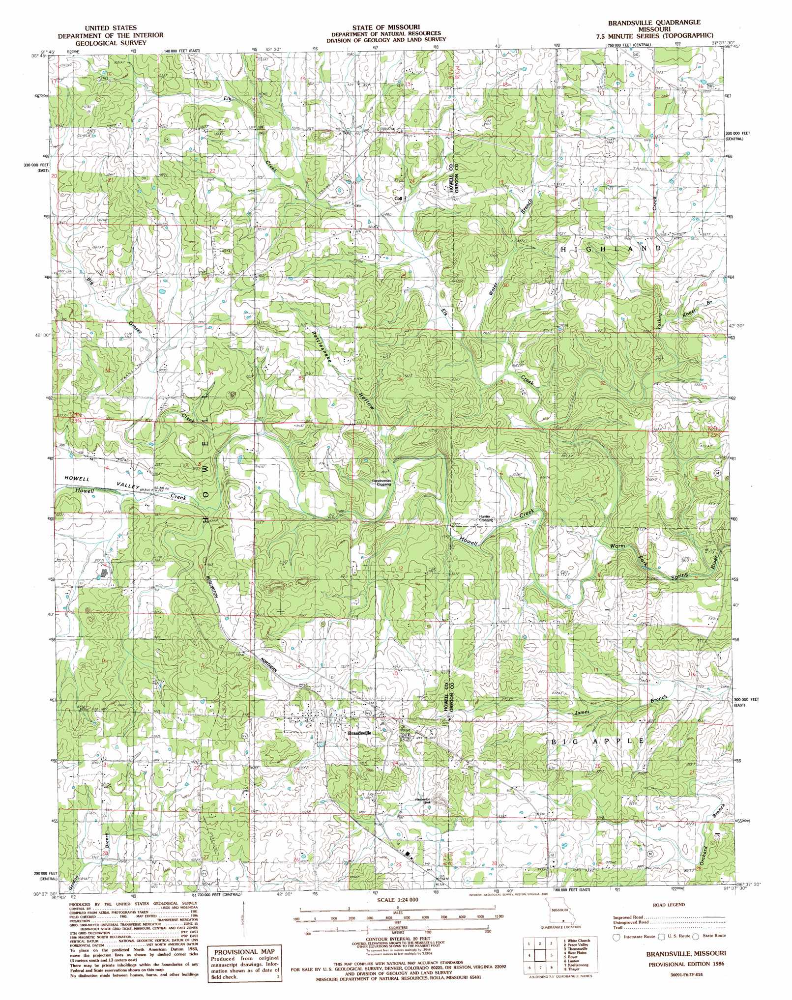
Brandsville Topo Map Missouri
To zoom in, hover over the map of Brandsville
USGS Topo Quad 36091f6 - 1:24,000 scale
| Topo Map Name: | Brandsville |
| USGS Topo Quad ID: | 36091f6 |
| Print Size: | ca. 21 1/4" wide x 27" high |
| Southeast Coordinates: | 36.625° N latitude / 91.625° W longitude |
| Map Center Coordinates: | 36.6875° N latitude / 91.6875° W longitude |
| U.S. State: | MO |
| Filename: | o36091f6.jpg |
| Download Map JPG Image: | Brandsville topo map 1:24,000 scale |
| Map Type: | Topographic |
| Topo Series: | 7.5´ |
| Map Scale: | 1:24,000 |
| Source of Map Images: | United States Geological Survey (USGS) |
| Alternate Map Versions: |
Thayer NW MO 1976, updated 1977 Download PDF Buy paper map Brandsville MO 1986, updated 1986 Download PDF Buy paper map Brandsville MO 2011 Download PDF Buy paper map Brandsville MO 2015 Download PDF Buy paper map |
1:24,000 Topo Quads surrounding Brandsville
Willow Springs South |
Trask |
Mountain View |
Montier |
Birch Tree |
Pomona |
White Church |
Peace Valley |
Thomasville |
Peidmont Hollow |
South Fork |
West Plains |
Brandsville |
Rover |
Alton |
Moody |
Lanton |
Koshkonong |
Thayer |
Conch |
Viola |
Salem Knob |
Camp |
Mammoth Spring |
Wirth |
> Back to 36091e1 at 1:100,000 scale
> Back to 36090a1 at 1:250,000 scale
> Back to U.S. Topo Maps home
Brandsville topo map: Gazetteer
Brandsville: Basins
Harbeston Sink elevation 271m 889′Brandsville: Dams
Omrie Sinclair Dam elevation 277m 908′Brandsville: Populated Places
Brandsville elevation 307m 1007′Cull elevation 266m 872′
Hunter Crossing elevation 238m 780′
Pocohontas Crossing elevation 250m 820′
Brandsville: Post Offices
Cull Post Office (historical) elevation 266m 872′Brandsville: Streams
Elk Creek elevation 230m 754′Garretts Branch elevation 240m 787′
Rattlesnake Branch elevation 244m 800′
Rover Branch elevation 263m 862′
Turkey Creek elevation 240m 787′
Water Branch elevation 245m 803′
Brandsville: Valleys
Howell Valley elevation 268m 879′Rattlesnake Hollow elevation 245m 803′
Brandsville digital topo map on disk
Buy this Brandsville topo map showing relief, roads, GPS coordinates and other geographical features, as a high-resolution digital map file on DVD: